Country: Mozambique
Administrative region: Sofala (Province)
Central co-ordinates: 18.5735 S, 34.83650 E
Area: 1594km²
Qualifying IPA Criteria
A(i)Site contains one or more globally threatened species, B(ii)Site contains an exceptional number of species of high conservation importance, C(iii)Site contains nationally threatened or restricted habitat or vegetation types, AND/OR habitats that have severely declined in extent nationally
IPA assessment rationale
Urema Valley and Sangarassa Forest qualifies as an Important Plant Area under criterion A(i), due to the presence of one Endangered species, Vepris myrei, and two Vulnerable species Erythrococca zambesiaca and Celosia pandurata. In addition, there are 13 endemic and near-endemic species within this IPA and the site therefore qualifies under sub-criterion B(ii) as one of the top 15 sites nationally for range restricted and endemic species. The presence of a large, high-quality expanse of seasonally inundated grassland, a nationally restricted habitat type associated with endemic species, at the site triggers sub-criterion C(iii).
Site description
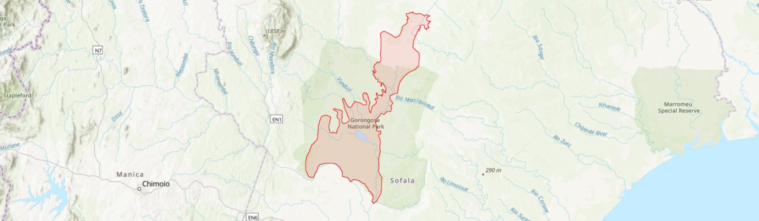
The Urema Valley and Sangarassa Forest IPA falls within Gorongosa National Park and Buffer Zone. Spanning four districts of Sofala Province, Maringue in the north-west, Cheringoma in the north-east, Muanza in the east and the vast majority within Gorongosa District, this site is centred on the far south of the African Great Rift Valley. With highly seasonal water levels, the vegetation is a complex mixture of open floodplain woodland-grassland to closed woodland and dry forest (Stalmans & Beilfuss 2008; Parque Nacional da Gorongosa 2019). The most distinct patch of dry forest within this IPA is Sangarassa Forest (-18.97°, 34.33°), 2 km north of the Pungue River. There are a number of species of conservation importance recorded from this small patch of dry forest and, as such, it is given particular prominence within this report.
The IPA is 1,594 km2 in area and has been delineated to encompass much of the valley floodplain within Gorongosa National Park. The northern boundary is adjacent to Chipanha village, 7 km south of the Gorongosa Buffer Zone boundary, and the southern boundary follows the Pungue River along the southern boundary of the national park core zone. While there is floodplain habitat both to the north and south of this IPA, in the national park buffer zone, this area is more heavily populated and so has been excluded, however, this IPA could be expanded if species of conservation interest are found in these areas in future.
Botanical significance
Urema Valley and Sangarassa Forest is home to a number of endemic and threatened species. For instance, Vepris myrei (EN) is known from this site, occurring in the dry forest patches north-east of Chitengo, where it is described as common (Tinley #2777), and in Sangarassa Forest. This species is threatened elsewhere by habitat conversion and its presence at this relatively secure location is important in preventing the extinction of V. myrei. Although there are unconfirmed records of V. myrei in both Malawi and Zimbabwe, it is thought that these may be specimens of a closely related species, V. rogersii, and so V. myrei may well be endemic to Mozambique, although further investigation is required to confirm this (Timberlake, in prep.).
Two Vulnerable species have also been recorded from this site. Erythrococca zambesiaca (VU) is of particular importance. Although it is also native to Malawi, E. zambesiaca is a range restricted species (under sub-criterion B(ii) of the IPA criteria), with an EOO (extent of occurrence) of 788 km2 area. Threatened elsewhere by the conversion of habitat to agriculture, the presence of E. zambesiaca within Sangarassa Forest is not only important for the continued survival of this species but is the only known location within Mozambique and represents the southern edge of its range (Timberlake 2019).
Celosia pandurata (VU), an endemic species, is also recorded from Sangarassa forest. A total of four Mozambican endemics occur within this forest patch and, hence, Sangarassa Forest is of particular importance within this IPA.
Within the IPA as a whole, 12 Mozambican endemics have been recorded. One of these species, Acacia torrei (LC) is limited only to a range of ca. 1,700 km2 upon the black alluvial clay soils of the Urema and Zangue valleys. This species is locally common in the north of the IPA and is currently assessed as Least Concern; the continued protection A. torrei receives within Gorongosa National Park is central to preventing it becoming globally threatened with extinction (Coates Palgrave et al. 2014). The Urema Valley also hosts the largest known population of another endemic species, Gyrodoma hispida (LC). G. hispida has been described as common within this IPA and so this is a key locality for preventing this species becoming threatened with extinction (Richards 2021).
The over 700 km2 of seasonally inundated grasslands within this IPA represent a habitat type of conservation interest for Mozambique (Stalmans & Beilfuss 2008). As well as hosting significant populations of the two endemic species mentioned above, this habitat type has a limited range across Mozambique. The seasonally inundated grasslands of this site represent one of the largest and highest quality examples of this habitat nationally and therefore trigger sub-criterion C(iii) of the IPA criteria for this site.
Habitat and geology
The plant communities within this IPA are highly variable, which likely reflects the underlying soil structure and moisture availability within the landscape (Stalmans & Beilfuss 2008). Much of the IPA has sandy soils, with black clay colluvial fan to the north (Steinbruch 2010). Acacia torrei in particular is reliant on these areas of black clay and is restricted to this substrate within Sofala Province (Coates Palgrave et al. 2014).
Lake Urema, just south of the centre of the valley, is supplied with drainage from both Mount Gorongosa and the surrounding plateau to the west and the Cheringoma Plateau to the east, with overflow joining the Pungue River at the southern boundary of this IPA (Stalmans & Beilfuss 2008). During the wet season, December to March, the water levels of Lake Urema and associated rivers increase to cover up to 40% of Gorongosa’s area (Stahl 2020), with much of the central stretch of this IPA, along with the southern boundary by the Pungue River, being inundated with water (Parque Nacional da Gorongosa 2019).
The vegetation types of Gorongosa National Park are categorised in Stalmans & Beilfuss (2008) and a summary of the relevant vegetation types is provided below.
The floodplain region is a largely open landscape dominated by seasonally inundated grasslands of various types including: Echinochloa – Chrysopogon, Setaria and Cynodon dactylon – Digitaria didactyla assemblages; the latter community is concentrated around Lake Urema and has almost no woody plants. On the lower slopes and drainage lines south of Lake Urema are areas of palm savanna consisting of open to closed Hyphaene stands with a grassy understory. Stands of Acacia xanthophloea, mixed Acacia-Combretum and Faidherbia albida also form open to closed areas of woodland within the floodplain and alluvial fan.
West of Chitengo Camp is Sangarassa Forest, a 1.6 km2 area of vegetation that is described on specimen vouchers as dense sand forest (e.g., Wursten #911). The forest is dominated by species such as Newtonia hildebrandtii and Xylia torreana (Tinley #2331). The understory includes the Mozambican endemic Millettia mossambicensis, while some species are associated with the termite mounds that border seasonal pans, such as Cola mossambicensis (NT).
To the south of the IPA, following the Pungue River, is closed woodland/dry forest dominated by Piliostigma thonningii and, in seasonally flooded areas, Borassus aethiopium (Stalmans & Beilfuss 2008; Hyde et al. 2020a, 2020b).
Conservation issues
The entirety of the Urema Valley and Sangarassa Forest falls within Gorongosa National Park and Buffer Zone with only the most northerly 220 km2 of the IPA falling within the buffer zone. This IPA is also encompassed within Gorongosa Mountain and National Park Important Bird Area and Gorongosa-Marromeu Key Biodiversity Area. The Urema Valley wetlands are of particular importance for bird species; Grey Crowned Crane (Balearica regulorum- EN) has been recorded here, while the area is possibly an important over-wintering ground for Great Snipe (Gallinago media- NT) (BirdLife International 2020). In addition, a 2014 count found that the population sizes of two avian taxa meet Ramsar site criteria; Yellow-billed Stork (Mycteria ibis- LC) exceeded the threshold of 1% of the population in sub-Saharan Africa (870 individuals) and the population of African Darter (Anhinga rufa- LC) exceeded 1% of individuals of this species in southern and eastern Africa (1,000 individuals) (Stalmans et al. 2014), although the area is not currently listed as a Ramsar site.
Mimosa pigra, a species that features in IUCN’s “100 of the World’s Worst Invasive Alien Species” (van der Weijden et al. 2004), is a major threat to the wetlands within this IPA and has established on the floodplain (Stalmans & Beilfuss 2008). This species forms dense thickets, excluding other species and converting floodplains into scrubland (Beilfuss 2007). However, it is thought that the re-introduction of ruminant grazers is helping to contain shrub encroachment (Guyton et al. 2020).
The management strategy for the site includes a cold burning of the valley early in the dry season (Stahl 2020). Research into fire and herbivory dynamics has been undertaken (see Stahl 2020) towards improving the use of fire for the continued restoration of the park following the Mozambican Civil War.
During the civil war, large herbivore populations declined by over 90% within Gorongosa National Park (Stalmans et al. 2019). Today, as populations continue to recover, a number of species within the national park are centred around the Urema Valley region. Hippo were released around Lake Urema in 2008 and African wild dog released in 2018, while the recovering Sungwe lion pride is centred around the streams south-west of Lake Urema. The vegetation within this IPA, as an important component of the ecosystem, therefore, makes an important contribution to the conservation of mammals within the national park, as well as the tourism that these mammal species attract.
However, as the number of large herbivores within the park increases, a change in dominant species has been recorded. Elephant, hippo and African buffalo previously dominated the pre-war large herbivore biomass, while in 2018 over 74% of large herbivore biomass recorded was waterbuck (Stalmans et al. 2019). It would be informative to monitor how these changing herbivory dynamics may be impacting plant communities, particularly habitats vital for rare or threatened plants species.
Much of this IPA has been unaffected by conversion of habitat to agriculture, a major threat to plant species across Mozambique (Darbyshire et al. 2019), likely because the vast majority of the IPA area falls within Gorongosa National Park. A total of ca. 200,000 people live within the buffer zone and Gorongosa National Park partners with these communities to build sustainable livelihood opportunities (Parque Nacional da Gorongosa 2019). To this end, GNP are working towards having a large Community Conservation Area proclaimed at the north-east boundary, which would include part of this IPA (M. Stalmans, pers. comm. 2021). Monitoring of populations of Acacia torrei in this area could be considered within conservation actions, to safeguard against threats to a key area of habitat for this range restricted endemic.
Ecosystem services
The Urema Valley region is regularly inundated with water (Stalmans & Beilfuss 2008). However, following Cyclone Idai in 2019, one of the worst weather events recorded in the southern hemisphere (Warren 2019), much of Gorongosa National Park was submerged. Although the cyclone made landfall near Beira, the Gorongosa area was impacted by heavy rain and extensive flooding, with communities living south of the national park severely impacted (Parque Nacional da Gorongosa 2019). However, the vegetation within the park is thought to have mitigated some of the impacts of the cyclone on local communities, with water being gradually released for over five months after the event, due to the complexity of the landscape in the Urema Valley area and beyond (Parque Nacional da Gorongosa 2019).
The landscapes of the Urema Valley, particularly the grasslands surrounding Lake Urema, have the greatest suitability for supporting grazers across the entirety of Goronogosa National Park and Buffer Zone (Stalmans & Beilfuss 2008). Therefore, through supporting some of the more charismatic mammals, the vegetation within this IPA makes a major contribution to attracting tourism to the area.
Site assessor(s)
Sophie Richards, Royal Botanic Gardens, Kew
Iain Darbyshire, Royal Botanic Gardens, Kew
IPA criterion A species
| Species | Qualifying sub-criterion | ≥ 1% of global population | ≥ 5% of national population | 1 of 5 best sites nationally | Entire global population | Socio-economically important | Abundance at site |
|---|---|---|---|---|---|---|---|
| Erythrococca zambesiaca Prain | A(i) |  |
|
|
 |
|
Unknown |
| Celosia pandurata Baker | A(i) | |
|
|
|
|
Unknown |
| Vepris myrei (Exell & Mendonça) Mziray | A(i) | |
|
|
|
|
Frequent |
Erythrococca zambesiaca Prain
Qualifying sub-criterion:
A(i)
≥ 1% of global population:
≥ 5% of national population:
1 of 5 best sites nationally:
Entire global population:
Socio-economically important:
Abundance at site:
Unknown
Celosia pandurata Baker
Qualifying sub-criterion:
A(i)
≥ 1% of global population:
≥ 5% of national population:
1 of 5 best sites nationally:
Entire global population:
Socio-economically important:
Abundance at site:
Unknown
Vepris myrei (Exell & Mendonça) Mziray
Qualifying sub-criterion:
A(i)
≥ 1% of global population:
≥ 5% of national population:
1 of 5 best sites nationally:
Entire global population:
Socio-economically important:
Abundance at site:
Frequent
IPA criterion C qualifying habitats
| Habitat | Qualifying sub-criterion | ≥ 5% of national resource | ≥ 10% of national resource | 1 of 5 best sites nationally | Areal coverage at site |
|---|---|---|---|---|---|
| Seasonally Inundated Grassland | C(iii) | |
|
|
780 |
Seasonally Inundated Grassland
Qualifying sub-criterion:
C(iii)
≥ 5% of national resource:
≥ 10% of national resource:
Areal coverage at site:
780
General site habitats
| General site habitat | Percent coverage | Importance |
|---|---|---|
| Grassland - Subtropical/Tropical Seasonally Wet/Flooded Lowland Grassland | |
Major |
| Savanna - Moist Savanna | |
Major |
| Forest - Subtropical/Tropical Dry Forest | |
Minor |
Grassland - Subtropical/Tropical Seasonally Wet/Flooded Lowland Grassland
Percent coverage:
Importance:
Major
Savanna - Moist Savanna
Percent coverage:
Importance:
Major
Forest - Subtropical/Tropical Dry Forest
Percent coverage:
Importance:
Minor
Land use types
| Land use type | Percent coverage | Importance |
|---|---|---|
| Nature conservation | 100 | Major |
| Tourism / Recreation | |
Major |
| Agriculture (arable) | |
Minor |
Nature conservation
Percent coverage:
100
Importance:
Major
Tourism / Recreation
Percent coverage:
Importance:
Major
Agriculture (arable)
Percent coverage:
Importance:
Minor
Threats
| Threat | Severity | Timing |
|---|---|---|
| Agriculture & aquaculture - Annual & perennial non-timber crops - Small-holder farming | Low | Ongoing - trend unknown |
| Climate change & severe weather - Storms & flooding | High | Past, likely to return |
| Natural system modifications - Fire & fire suppression - Trend Unknown/Unrecorded | Unknown | Ongoing - stable |
Agriculture & aquaculture - Annual & perennial non-timber crops - Small-holder farming
Severity:
Low
Timing:
Ongoing - trend unknown
Climate change & severe weather - Storms & flooding
Severity:
High
Timing:
Past, likely to return
Natural system modifications - Fire & fire suppression - Trend Unknown/Unrecorded
Severity:
Unknown
Timing:
Ongoing - stable
Protected areas
| Protected area name | Protected area type | Relationship with IPA | Areal overlap |
|---|---|---|---|
| Gorongosa National Park and Buffer Zone | National Park | protected/conservation area encompasses IPA | 1280 |
Gorongosa National Park and Buffer Zone
Protected area type:
National Park
Relationship with IPA:
protected/conservation area encompasses IPA
Areal overlap:
1280
Conservation designation
| Designation name | Protected area | Relationship with IPA | Areal overlap |
|---|---|---|---|
| Gorongosa Mountain and National Park | Important Bird Area | protected/conservation area overlaps with IPA | 1030 |
| Gorongosa-Marromeu | Key Biodiversity Area | protected/conservation area encompasses IPA | 1280 |
Gorongosa Mountain and National Park
Protected area:
Important Bird Area
Relationship with IPA:
protected/conservation area overlaps with IPA
Areal overlap:
1030
Gorongosa-Marromeu
Protected area:
Key Biodiversity Area
Relationship with IPA:
protected/conservation area encompasses IPA
Areal overlap:
1280
Management type
| Management type | Description | Year started | Year finished |
|---|---|---|---|
| Protected Area management plan in place | The focus of Gorongosa has been set out in the 2020-2050 Strategic Plan and involves improving the capacity of the national park to “preserve, protect and manage the diverse ecosystems within the Park” while also working with communities within the buffer zone, making a particular effort to reach women in these communities, to improve sustainable economic opportunities (Parque Nacional de Gorongosa 2019). | 2020 | 2050 |
Protected Area management plan in place
The focus of Gorongosa has been set out in the 2020-2050 Strategic Plan and involves improving the capacity of the national park to “preserve, protect and manage the diverse ecosystems within the Park” while also working with communities within the buffer zone, making a particular effort to reach women in these communities, to improve sustainable economic opportunities (Parque Nacional de Gorongosa 2019).
Year started:
2020
Year finished:
2050
Bibliography
Important Bird Areas factsheet: Gorongosa Mountain and National Park
The endemic plants of Mozambique: diversity and conservation status
PhytoKeys, Vol 136, page(s) 45-96 Available online
Acacia torrei. The IUCN Red List of Threatened Species 2014: e.T19891788A63707954
Our Gorongosa - A Park for the People. Annual Report 2019.
How one of Africa’s great parks is rebounding from war
National Geographic Available online
Landscapes of Gorongosa National Park
Adaptive Management of the Invasive Shrub Mimosa pigra at Gorongosa National Park
Trophic rewilding revives biotic resistance to shrub invasion
Nature Ecology and Evolution, Vol 4, page(s) 5 Available online
Flora of Mozambique: Google Maps: Borassus aethiopum
Flora of Mozambique: Google maps: Piliostigma thonningii
Pyric herbivory: Understanding fire-herbivore interactions in Gorongosa National Park.
War-induced collapse and asymmetric recovery of large-mammal populations in Gorongosa National Park, Mozambique
PLoS ONE, Vol 14 Available online
A Major Waterbird Breeding Colony at Lake Urema, Gorongosa National Park, Moçambique
Durban Natural Science Museum Novitates, Vol 37, page(s) 54-57 Available online
Geology and geomorphology of the Urema Graben with emphasis on the evolution of Lake Urema
Journal of African Earth Sciences, Vol 58, page(s) 272-284
100 of the World’s Worst Invasive Alien Species: A selection from the Global Invasive Species Database
Biological Globalisation, page(s) 206–208
A preliminary study on the distribution of Mimosa pigra in Gorongosa National Park: reasons and causes
Why Cyclone Idai is one of the Southern Hemisphere’s most devastating storms
Nature News Available online
Erythrococca zambesiaca. The IUCN Red List of Threatened Species 2019: e.T146427908A146819180


Recommended citation
Sophie Richards, Iain Darbyshire (2024) Tropical Important Plant Areas Explorer: Urema Valley and Sangarassa Forest (Mozambique). https://tipas.kew.org/site/urema-valley-and-sangarassa-forest/ (Accessed on 27/07/2024)