Country: Mozambique
Administrative region: Niassa (Province)
Central co-ordinates: 11.7828 S, 35.06750 E
Area: 741km²
Qualifying IPA Criteria
A(iii)Site contains one or more highly restricted endemic species that are potentially threatened, C(iii)Site contains nationally threatened or restricted habitat or vegetation types, AND/OR habitats that have severely declined in extent nationally
IPA assessment rationale
The Txitonga Mountains qualify as an Important Plant Area under sub-criterion C(iii), the site has significant areas of montane grassland, a restricted and nationally threatened habitat. While montane scrubland is also present at this site, and may well also be of conservation importance, it is difficult to spatially define and cannot be assessed at this time. The presence of Hartliella sp. nov., a highly restricted endemic, also triggers sub-criterion A(iii) for this site. It is highly likely that, as more botanical collection and research is conducted on the flora of this site, more threatened and endemic species will be recorded.
Site description
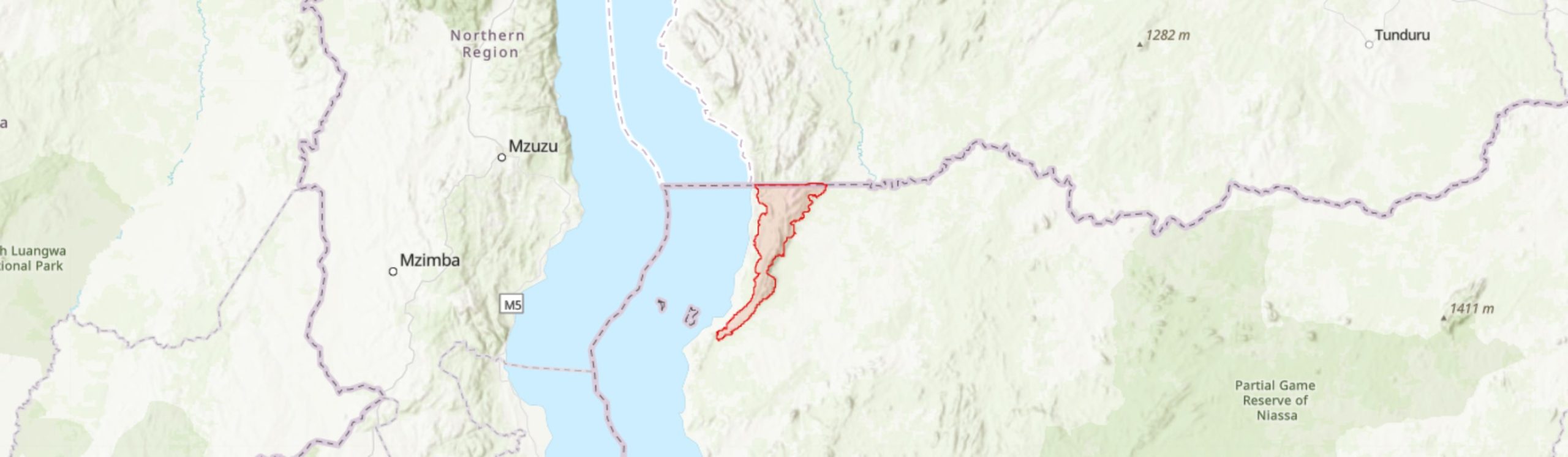
The Txitonga Mountains lie in the northwest of Lago district in Niassa Province. The mountains extend south from the southern end of the Kipengere Range in Tanzania and form part of the eastern escarpment of the East African rift. These mountains are isolated from the other highland areas in Niassa province - the broad Lichinga plateau area and outlying Mount Mecula and Mount Yao. They are therefore likely to support a distinct biodiversity for Mozambique, closely allied to that in southwest Tanzania. Mount Txitonga (or Chitonga) is the highest peak in the range at ca. 1848 m elevation. The IPA extends south from the Tanzanian border and includes a core zone of montane habitat over 1200 m elevation situated within a larger buffer zone of foothills extending towards the Messinge river plain to the east and the shore of Lake Niassa to the west. The IPA is within the Lake Niassa Reserve, also a Ramsar site, that includes both Lake Niassa and the adjacent terrestrial zone (Ramsar 2011).
Botanical significance
A significant area of montane habitat can be found in the Txitonga Mountains including montane grassland, a restricted and threatened habitat of Mozambique. There is also montane scrubland present within this IPA, which may also be of national conservation importance; however, this habitat type is difficult to define spatially, and so further research would be required.
The site is not well-studied botanically and several possible plant species new to science were recorded during an expedition in 2019 (Osborne et al. 2019). These include a species of Streptocarpus allied to S. michelmorei but apparently unmatched, a potentially new species of Bothriocline, and a small rosette herb, Hartliella sp. nov. The latter genus is, interestingly, an indicator of metal-rich soils and the genus as a whole was previously known only from the Katanga region of D.R. Congo, and northern Zambia. Hartliella sp. nov. is highly localized, known only from a single location where it was locally common. As Hartliella sp. nov. occupies a range of less than 100 km2 and is yet to be assessed for the IUCN Red List, it triggers A(iii) of the IPA sub-criteria. This species may well be assessed as Critically Endangered in future as habitat is being lost through mining.
A number of other interesting taxa were collected during the 2019 expedition, including several records new to Mozambique - Barleria holstii (LC), Erica woodii Leptoderris brachyptera (LC), Polygala gossweileri and Protea micans subsp. trichophylla - and two records of species not previous collected in northern Mozambique - Plectranthus kapatensis and Vernonia holstii. With further investigation, many more notable plant species are likely to be collected within this IPA.
Habitat and geology
The Txitonga Mountains are dominated by metasedimentary rocks, predominantly meta-greywacke, meta-sandstone and schists, the Txitonga geological group also hosts the Niassa Gold Belt the presence of which has motivated goldmining within the IPA (Bingen et al. 2007). Soils have not been fully categorised; however, the presence of Hartliella potentially indicates metal-rich soils. The site experiences average annual precipitation of around 1,312 mm on the slopes and 1,330 mm on the higher ridges, with the vast majority falling during the wet season between November and April. Temperatures average at 21°C on the escarpments and 17.8°C on the upper ridges (Lötter et al. 2021).
The vegetation on the foothills and slopes of the mountains is predominantly woodland with narrow strips of moist gallery forest growing along deep stream gullies. At higher altitudes a more open montane savannah, montane scrubland and montane grassland occur. The site is underexplored botanically and the habitat information below was gathered during an expedition into the mountains in 2019 (Osborne et al. 2019).
The woodland that covers the mountain slopes and foothills of the Txitonga Mountains is extensive, supporting a high diversity of trees, shrubs, herbs and grasses. There is also much local variation in the woodland vegetation across the landscape. A large part of the woodland is miombo, dominated by Brachystegia spiciformis and B. boehmii. Uapaca kirkiana is also among the dominant species, in places forming dense, monospecific stands. Uapaca nitida, Faurea rochetiana, Parinari curatellifolia, Diplorhynchus condylocarpon, Monotes engleri and Pericopsis angolensis are frequent, while locally common shrubs include Droogmansia pteropus and Cryptosepalum maraviense.
Deep stream gullies are frequent and conspicuous on satellite imagery (Google Earth 2020). The stream gullies support humid gallery forest and a very different flora from the wooded hillsides. Brachystegia tamarindoides subsp. microphylla is dominant on the upper level of the gallery forest, growing with Burkea africana and reaching a canopy height to ca. 25 m. At the bottom of the stream gullies, Breonadia salicina and stilt-rooted Uapaca lissopyrena are common, growing with Treculia africana, Erythrophleum suaveolens and Bridelia micrantha. The understorey includes Erythroxylum emarginatum and abundant lianas. Shaded rocks along the streams support moisture-loving species including ferns and Streptocarpus sp.
At higher altitudes the woodland becomes more open in places and the canopy lower, grading into montane savannah grassland and scrubland with rocky outcrops. Woody species are sparse in the savanna and include Uapaca kirkiana, Faurea rochetiana, Protea spp., Erica sp., Psorospermum febrifugum and Myrica pilulifera, mostly to less than 3 m tall. Along the mountain ridge, the low shrubs Kotschya strigosa and Cryptosepalum maraviense are common. The montane grassland is mostly short, to ca. 50 cm in height and rich in dwarf shrubs, herbs and geophytes.
Conservation issues
The Txitonga Mountains fall within Lake Niassa Partial Reserve and Ramsar site. Although there has been some monitoring of deforestation in the area by WWF (WWF 2011), much of the focus of these conservation areas is, on the freshwater rather than montane ecosystems.
Environmental disturbance from gold mining is extensive and ongoing leaving areas of broken rock, deeply eroded fissures, silted rivers and mercury pollution. The mining is legal, licensed through the community mining association. Water is channelled to mining sites over long distances to facilitate the mining process and the water channels are maintained over many years. The risk of mercury pollution to the local people is recognised in Tulo Calanda, to the east of the mountains, where water is piped to the village from a clean site unaffected by the mining. Despite being within the Lake Niassa Reserve, a partial reserve, there appears to be no control over the use of mercury (Osborne et al. 2019).
Across most of Mozambique the expansion of subsistence ‘machamba’ agriculture is the main cause of habitat loss. In the Txitonga Mountains this is not the case and there is very little cultivation. Here gold mining is more profitable than agriculture and is driving the local economy. The Txitonga Mountains support large areas of valuable natural vegetation. However, gold mining is taking place at multiple sites in the mountains causing habitat loss locally, wider disturbance to the hydrology and environmental pollution (Osborne et al. 2019). The ongoing expansion of gold mining sites poses both a current and future threat to the vegetation.
In addition to the direct impacts of gold mining, the presence of gold miners in the mountains has led to an increased frequency of uncontrolled wildfires that poses a serious threat to the vegetation. Fires are set both intentionally for hunting and unintentionally from cooking fires. Monitoring uncontrolled burning makes up a large proportion of the work of the local government Environmental Officers (Fiscais) and more resources are needed to control this activity (Osborne et al. 2019).
Ecosystem services
The Txitonga Mountains have a high plant diversity value, in part due to their unique biogeography within Mozambique. The vegetation at this site contributes to carbon sequestration and storage, prevents soil erosion on the slopes and provides habitat for flora and fauna. The mountains also provide a watershed for the local area though this is currently severely threatened by gold mining activity.
Site assessor(s)
Jo Osborne, Royal Botanic Gardens, Kew
Sophie Richards, Royal Botanic Gardens, Kew
Iain Darbyshire, Royal Botanic Gardens, Kew
IPA criterion A species
| Species | Qualifying sub-criterion | ≥ 1% of global population | ≥ 5% of national population | 1 of 5 best sites nationally | Entire global population | Socio-economically important | Abundance at site |
|---|---|---|---|---|---|---|---|
| Hartliella sp. nov. J. Osborne 1711 | A(iii) |  |
|
|
|
 |
Occasional |
Hartliella sp. nov. J. Osborne 1711
Qualifying sub-criterion:
A(iii)
≥ 1% of global population:
≥ 5% of national population:
1 of 5 best sites nationally:
Entire global population:
Socio-economically important:
Abundance at site:
Occasional
General site habitats
| General site habitat | Percent coverage | Importance |
|---|---|---|
| Savanna - Moist Savanna | |
Major |
| Shrubland - Subtropical/Tropical High Altitude Shrubland | |
Major |
| Grassland - Subtropical/Tropical High Altitude Grassland | |
Major |
| Forest - Subtropical/Tropical Moist Montane Forest | |
Minor |
| Wetlands (inland) - Permanent Rivers, Streams, Creeks [includes waterfalls] | |
Minor |
Savanna - Moist Savanna
Percent coverage:
Importance:
Major
Shrubland - Subtropical/Tropical High Altitude Shrubland
Percent coverage:
Importance:
Major
Grassland - Subtropical/Tropical High Altitude Grassland
Percent coverage:
Importance:
Major
Forest - Subtropical/Tropical Moist Montane Forest
Percent coverage:
Importance:
Minor
Wetlands (inland) - Permanent Rivers, Streams, Creeks [includes waterfalls]
Percent coverage:
Importance:
Minor
Land use types
| Land use type | Percent coverage | Importance |
|---|---|---|
| Nature conservation | |
Major |
| Extractive industry | |
Major |
Nature conservation
Percent coverage:
Importance:
Major
Extractive industry
Percent coverage:
Importance:
Major
Threats
| Threat | Severity | Timing |
|---|---|---|
| Energy production & mining - Mining & quarrying | High | Ongoing - trend unknown |
| Natural system modifications - Fire & fire suppression - Increase in fire frequency/intensity | High | Ongoing - trend unknown |
| Pollution - Industrial & military effluents - Seepage from mining | Unknown | Ongoing - trend unknown |
Energy production & mining - Mining & quarrying
Severity:
High
Timing:
Ongoing - trend unknown
Natural system modifications - Fire & fire suppression - Increase in fire frequency/intensity
Severity:
High
Timing:
Ongoing - trend unknown
Pollution - Industrial & military effluents - Seepage from mining
Severity:
Unknown
Timing:
Ongoing - trend unknown
Protected areas
| Protected area name | Protected area type | Relationship with IPA | Areal overlap |
|---|---|---|---|
| Lake Niassa | Partial Reserve | protected/conservation area encompasses IPA | 941 |
Lake Niassa
Protected area type:
Partial Reserve
Relationship with IPA:
protected/conservation area encompasses IPA
Areal overlap:
941
Conservation designation
| Designation name | Protected area | Relationship with IPA | Areal overlap |
|---|---|---|---|
| Lake Niassa | Ramsar | protected/conservation area encompasses IPA | 941 |
Lake Niassa
Protected area:
Ramsar
Relationship with IPA:
protected/conservation area encompasses IPA
Areal overlap:
941
Management type
| Management type | Description | Year started | Year finished |
|---|---|---|---|
| No management plan in place | |
|
No management plan in place
Year started:
Year finished:
Bibliography
Lake Niassa Ramsar Site
Google Earth Satellite Imagery
Historical Vegetation Map and Red List of Ecosystems Assessment for Mozambique – Version 1.0 – Final report
The geology of Niassa and Cabo Delgado Provinces with parts of Zambesia and Nampula Provinces, Mozambique
Lake Niassa Declared a Reserve
Niassa Province – Lago District mountains and Njesi Plateau


Recommended citation
Jo Osborne, Sophie Richards, Iain Darbyshire (2024) Tropical Important Plant Areas Explorer: Txitonga Mountains (Mozambique). https://tipas.kew.org/site/txitonga-mountains/ (Accessed on 27/07/2024)