Country: Mozambique
Administrative region: Zambézia (Province)
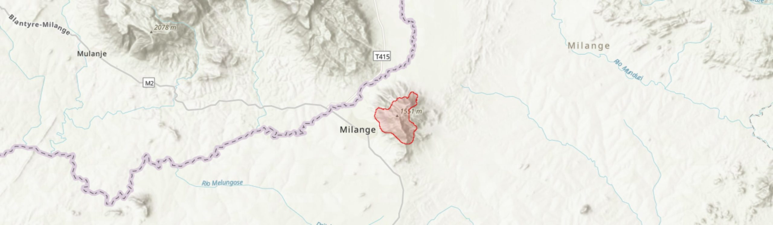
Central co-ordinates: 16.0873 S, 35.80350 E
Area: 13.7km²
Qualifying IPA Criteria
A(i)Site contains one or more globally threatened species
IPA assessment rationale
Serra Tumbine qualifies as an IPA under criterion A. Three sub-criterion A(i) species are recorded from this IPA: Encephalartos gratus (VU), Pavetta chapmanii (VU) and Streptocarpus leptopus (EN). Serra Tumbine is particularly important for the lattermost species as one of only two sites globally and the only Mozambican IPA from which S. leptopus is known.
Site description
Serra Tumbine is a mountain in Milange District, Zambézia Province, Mozambique. The peak reaches 1,548 m and the entire mountain is approximately 8 km in diameter (Woolley 1987). Serra Tumbine is considered to be an outlier of the Mulanje massif, a short distance across the border in Malawi, and is also part of the Mulanje-Namuli-Ribaue centre of endemism (Darbyshire et al. 2019). Milange town lies at the western foot of the mountain and there are a small number of residents who live along the 474 road that runs from the east of Serra Tumbine to Milange. Serra Tumbine has a number of aquifers, and it appears from satellite imagery that there is agricultural land associated with the streams that originate on the mountain, particularly around Milange town.
The area of this IPA is 13.7 km2. While the dense montane forest is of conservation significance, only remnants of this habitat remain due to extensive conversion to agriculture. During the Mozambican Civil War, people fleeing the conflict settled on Serra Tumbine and began cultivating crops on the mountain, particularly the north-eastern slopes (Manuel 2007). It is thought that the loss of forested areas from the mountain may have contributed to a catastrophic landslide in 1998 (World Bank 2019). At lower altitudes the habitat is characterised by miombo woodland, although much of this area has also been converted to agriculture and has been excluded from this IPA.
Botanical significance
Three threatened species have been recorded from Serra Tumbine. There is one Endangered species, Streptocarpus leptopus, which is only known from this IPA and neighboring Mount Mulanje in Malawi and is threatened by clearing of its forest habitat at both sites (Richards 2021). Two Vulnerable species are also known from this site: Encephalartos gratus (VU), a cycad mainly threatened in Mozambique by annual burning and the resulting decrease in seedling recruitment (Strugnell 2002; Donaldson 2010; Burrows et al. 2018), and Pavetta chapmanii (VU), which is only known from six locations within the Mulanje-Namuli-Ribaue chain of mountains (Timberlake 2020). In addition, a Near Threatened species, Cola mossambicensis, has also been collected from Serra Tumbine. Many of the collections for these species are historical so it would be highly desirable to confirm the continued presence of each at this site and establish how large the populations are within this IPA.
There has not yet been a full botanical inventory of Serra Tumbine but it is possible that more species of conservation significance are present but have yet to be documented from the site or assessed for the IUCN Red List. For instance, nearby Mount Mulanje is known for its high number of endemic and near endemic species (Strugnell 2002) and, although many of these species are found in high altitude grasslands and rocky outcrops that are largely absent from Serra Tumbine, we could still expect some species found on Mulanje to be shared with Serra Tumbine.
While the remaining area of mid-altitude forest is not extensive enough for Serra Tumbine to meet C(iii) of the IPA criteria, it has been suggested that the high root density of the forest stabilises the soil and so prevents erosion and landslides (Manuel 2007). Although much of this forest has been cleared for agriculture (World Bank 2019), it is likely that the remaining fragments still provide this important ecosystem service.
Habitat and geology
The remaining mid-altitude montane forest on Serra Tumbine is of great conservation importance. Although only very limited botanical survey work has been conducted here, in a botanical collection at this site by Correia (MF #510), the forest was described as dense, with species including Albizia, Newtonia (described on the specimen voucher as Piptadenia by Correira, but this almost certainly a synonym), Chrysophyllum and Macaranga. In the nearby Chisongeli forest on Mount Mulanje, Newtonia buchananii has been recorded as a dominant species (Dowsett-Lemaire 1988) and it is therefore also likely to be dominant in the forests of Serra Tumbine. There is around 2 – 4 km2 of forest remaining on Tumbine, mostly located at altitudes above 1,000 m, with the largest patch overlooking Milange town and some smaller patches in steep gullies and on the northerly peak.
On all of the lower slopes of the mountain (< 1,000 m), as well as higher altitudes on the western side (up to around 1,300 m), subsistence agriculture dominates, with crops including maize, beans, banana, manioc and sorghum (Manuel 2007). Amongst the agricultural clearings below 1,000 m, there are small patches of miombo woodland remaining, likely dominated by Brachystegia, probably B. spiciformis as is the case on the foothills of Mount Mulanje (Dowsett-Lemaire 1988). It has been suggested that these miombo woodlands play and important role as a buffer vegetation below mid-montane forests (Timberlake et al. 2007); however, very little remains on Serra Tumbine.
On Mount Chiperone, forest clearance has been observed to promote the establishment of edge species, such as Albizia gummifera, which in turn prevents the re-establishment of forest species (Timberlake et al. 2007). It is possible that the same process has also occurred on Serra Tumbine where forest has been cleared by anthropogenic disturbance or possibly due to landslides.
In terms of geology, Serra Tumbine is a Late Cretaceous to Early Jurassic syenite intrusion within the surrounding Pre-Cambrian metamorphic granulites and gneisses (Woolley 1987; Manuel 2007). The soils derived from the syenites are dark brown with a humic top layer, while the granulites and gneisses form lateritic soils. Both soil types are deep with an overlying layer of colluvial materials varying in size from fine sediments to large boulders (Manuel 2007). Rainfall on the mountain is around 1,200 to 2,000 mm per year, peaking between January and March (Manuel 2007). There is no temperature data for the mountain itself, although nearby Milange town experiences its highest average temperature of 27°C in October and November and an average low of 19°C in June and July (World Weather Online 2021), although it is likely cooler on the upper slopes of the mountain and may possibly experience mists as observed on Mount Chiperone to the south (Timberlake et al. 2007).
Conservation issues
This IPA does not fall within a protected area, Important Bird Area (IBA) or Key Biodiversity Area. There has been little scientific research into the animals of Serra Tumbine, however, the nearby Mount Mulanje is an IBA and it is possible that some of the important bird species from Mulanje occupy Serra Tumbine at least transiently.
As a result of the Mozambican Civil War, people from various places fleeing conflict settled on Serra Tumbine and began occupying the slopes of the mountain and cultivating crops. The lower root density of these crops, compared to the forest that previously occupied these slopes, provides less soil stabilisation and is believed to have contributed to a catastrophic landslide at this site in 1993 (Manuel 2007). These agricultural practices on the slopes of the mountain have continued since the last landslide (Achar 2012).
Other causes of the 1998 landslide are also linked to clearing of vegetation, including high levels of tree felling for charcoal production and fires (Manuel 2007). It is unclear whether the fires have increased in frequency due to anthropogenic burning. Fires are used on Mount Mulanje by hunters to clear the bush (Wisborg & Jumbe 2010) and on Mount Chiperone both to hunt and to clear areas for small-scale cultivation (Timberlake et al. 2007); we may therefore expect that at least some of the fires on Serra Tumbine have been related to human activities.
The landslides themselves, of which there have been four between 1940 and 2000, have likely caused massive disturbance to vegetation, as records of the 1993 landslide suggest that high volumes of debris were carried down the mountain (World Bank 2019). This most recent landslide had a huge impact on the local landscape - it is reported that 1,000 hectares of crops were destroyed. The extent of damage to the mid-altitude forest stands is not well-documented, however, it is known that tree trunks came down the mountain in the debris and that large landslides have the potential to clear forests, remove topsoil and make land less productive (Forbes & Broadhead 2013), the latter consequence possibly exacerbating the problem of conversion of forest to agriculture on the mountain.
Support for sustainable food and timber production is required to prevent further landslide catastrophes, which in 1998 caused devastating loss of life and casualties, while also enabling local people to meet their consumption needs. A project run by NGOs Legado and Nitidæ on Mount Namuli has been working with communities to establish a community protected area, secure land rights for local people and promote sustainable economic development for these communities. Part of this work includes a process of delineation a core zone, where conservation is a priority, while using agroecological research to increase production of crops outside this core zone (Nitidæ 2021). A similar approach on Serra Tumbine could help protect and regenerate forests on the mountain, which would both benefit local communities and the threatened species residing in this habitat.
Ecosystem services
The forested areas of Serra Tumbine are important for stabilising the soils, due to the high root density provided by the forest vegetation. It is thought that deforestation, combined with heavy rains and the geology of the mountain, make landslides more likely on Serra Tumbine (World Bank 2019). As a result of the 1998 landslide, 200 people died, 4,000 were displaced and disease outbreaks quickly followed. In addition, 1,000 hectares of crops were lost, much of the area became flooded and there was damage to homes, roads, bridges and water supplies (Manuel 2007). It is therefore clear that forest stands on the mountain play an important role in protecting the lives and well-being of the people living nearby.
It is likely that the many aquifers under Serra Tumbine are an important source of water, at the very least providing moisture required for farming and possibly also as a source of clean drinking water, especially when refugees began occupying the mountain in the 1990s.
Timber is extracted from the mountain for the production of charcoal (Manuel 2007). It has not been documented whether hunting occurs here, but it is reported on other mountains in the area, Mulanje and Chiperone (Timberlake et al. 2007; Wisborg & Jumbe 2010), so it is likely that some hunting also occurs on Serra Tumbine. However, with very little forest left, the numbers of game available would have likely decreased. Food production on the mountain is largely from small-scale cultivation of crops such as maize, beans, banana trees, manioc and sorghum. While the continuation of these agricultural practices makes future landslides more likely (Achar 2012), and encroachment will lead to the further loss of the already nationally threatened mid-altitude forests, local people are reliant on these farms for food and so sustainable alternatives should be found.
Site assessor(s)
Sophie Richards, Royal Botanic Gardens, Kew
Iain Darbyshire, Royal Botanic Gardens, Kew
IPA criterion A species
| Species | Qualifying sub-criterion | ≥ 1% of global population | ≥ 5% of national population | 1 of 5 best sites nationally | Entire global population | Socio-economically important | Abundance at site |
|---|---|---|---|---|---|---|---|
| Pavetta chapmanii Bridson | A(i) |  |
 |
|
|
|
Unknown |
| Encephalartos gratus Prain | A(i) | |
|
|
|
|
Unknown |
| Streptocarpus leptopus Hilliard & B.L.Burtt | A(i) | |
|
|
|
|
Unknown |
Pavetta chapmanii Bridson
Qualifying sub-criterion:
A(i)
≥ 1% of global population:
≥ 5% of national population:
1 of 5 best sites nationally:
Entire global population:
Socio-economically important:
Abundance at site:
Unknown
Encephalartos gratus Prain
Qualifying sub-criterion:
A(i)
≥ 1% of global population:
≥ 5% of national population:
1 of 5 best sites nationally:
Entire global population:
Socio-economically important:
Abundance at site:
Unknown
Streptocarpus leptopus Hilliard & B.L.Burtt
Qualifying sub-criterion:
A(i)
≥ 1% of global population:
≥ 5% of national population:
1 of 5 best sites nationally:
Entire global population:
Socio-economically important:
Abundance at site:
Unknown
IPA criterion C qualifying habitats
| Habitat | Qualifying sub-criterion | ≥ 5% of national resource | ≥ 10% of national resource | 1 of 5 best sites nationally | Areal coverage at site |
|---|---|---|---|---|---|
| Medium Altitude Moist Forest 900-1400 m | C(iii) | |
|
|
1.8 |
Medium Altitude Moist Forest 900-1400 m
Qualifying sub-criterion:
C(iii)
≥ 5% of national resource:
≥ 10% of national resource:
Areal coverage at site:
1.8
General site habitats
| General site habitat | Percent coverage | Importance |
|---|---|---|
| Forest - Subtropical/Tropical Moist Montane Forest | |
Minor |
| Savanna - Moist Savanna | |
Major |
| Artificial - Terrestrial - Arable Land | |
Major |
Forest - Subtropical/Tropical Moist Montane Forest
Percent coverage:
Importance:
Minor
Savanna - Moist Savanna
Percent coverage:
Importance:
Major
Artificial - Terrestrial - Arable Land
Percent coverage:
Importance:
Major
Land use types
| Land use type | Percent coverage | Importance |
|---|---|---|
| Agriculture (arable) | |
Major |
| Harvesting of wild resources | |
Minor |
Agriculture (arable)
Percent coverage:
Importance:
Major
Harvesting of wild resources
Percent coverage:
Importance:
Minor
Threats
| Threat | Severity | Timing |
|---|---|---|
| Agriculture & aquaculture - Annual & perennial non-timber crops - Small-holder farming | High | Ongoing - trend unknown |
| Natural system modifications - Fire & fire suppression - Increase in fire frequency/intensity | Unknown | Ongoing - trend unknown |
| Biological resource use - Logging & wood harvesting | Low | Ongoing - trend unknown |
Agriculture & aquaculture - Annual & perennial non-timber crops - Small-holder farming
Severity:
High
Timing:
Ongoing - trend unknown
Natural system modifications - Fire & fire suppression - Increase in fire frequency/intensity
Severity:
Unknown
Timing:
Ongoing - trend unknown
Biological resource use - Logging & wood harvesting
Severity:
Low
Timing:
Ongoing - trend unknown
Management type
| Management type | Description | Year started | Year finished |
|---|---|---|---|
| No management plan in place | |
|
No management plan in place
Year started:
Year finished:
Bibliography
The endemic plants of Mozambique: diversity and conservation status
PhytoKeys, Vol 136, page(s) 45-96 Available online
Trees and Shrubs Mozambique
Pavetta chapmanii. The IUCN Red List of Threatened Species 2020: e.T146652565A146819426
Biodiversity and Conservation of Mount Chiperone, Mozambique
Darwin Initiative Award 15/036: Monitoring and Managing Biodiversity Loss in South-east Africa's Montane Ecosystems, page(s) 1-33 Available online
Encephalartos gratus. The IUCN Red List of Threatened Species 2010: e.T41916A10594309
ZAMBÉZIA -Queimadas e Agricultura Rudimentar Podem Provocar Aluimento de Terras Em Gúruè
MOZAMBIQUE: News reports & clippings Available online
The Forest Vegetation of Mt Mulanje (Malawi): A Floristic and Chorological Study along an Altitudinal Gradient (650-1950 m)
Bulletin du Jardin botanique national de Belgique / Bulletin van de National Plantentuin van België, Vol 58, page(s) 77-107
Forests and Landslides: The Role of Trees and Forests in the Prevention of Landslides and Rehabilitation of Landslide-Affected Areas in Asia. Second Edition
Reduction and Management of Geo-Hazards in Mozambique
International Journal for Disaster Management & Risk Reduction, Vol 1, page(s) 18-23 Available online
Endemics of Mt. Mulanje. The Endemic Spermatophytes of Mt. Mulanje, Malawi
Systematics and Geography of Plants, Vol 72, page(s) 11-26 Available online
Disaster Risk Profile: Mozambique
Mulanje Mountain Biodiversity Conservation Project: Mid-Term Review for the Norwegian Government
Alkaline rocks and carbonatites of the world: Africa
NAMULI SKY ISLAND - Creation of a new protected area around Mount Namuli – Nitidæ
Streptocarpus leptopus. The IUCN Red List of Threatened Species
Milange Monthly Climate Averages


Recommended citation
Sophie Richards, Iain Darbyshire (2024) Tropical Important Plant Areas Explorer: Serra Tumbine (Mozambique). https://tipas.kew.org/site/serra-tumbine/ (Accessed on 27/07/2024)