Country: Mozambique
Administrative region: Cabo Delgado (Province)
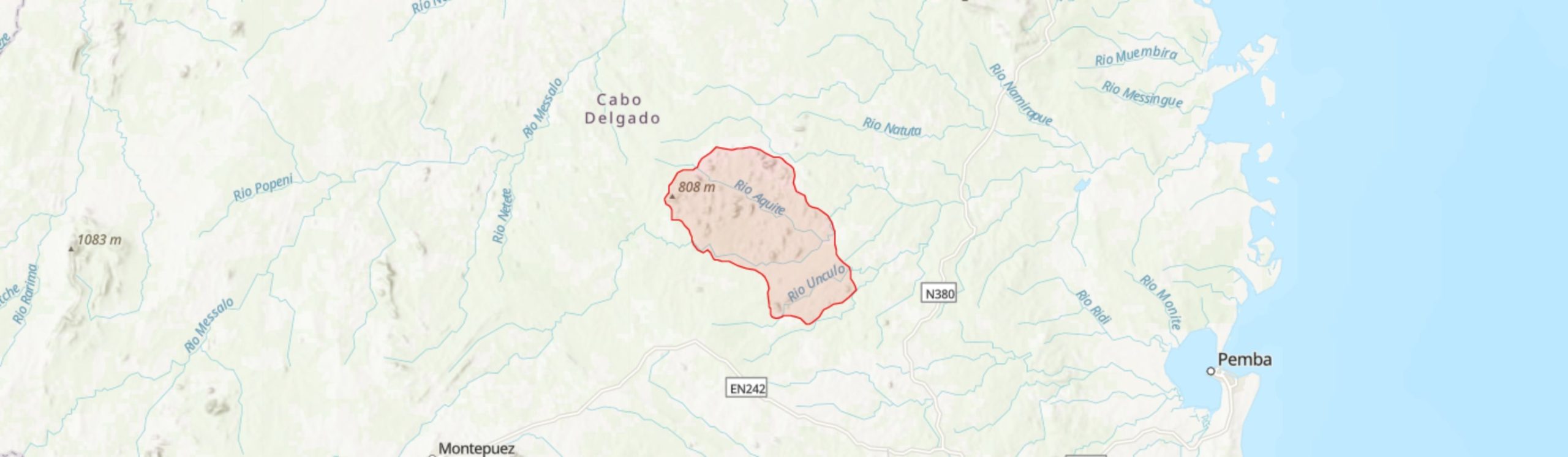
Central co-ordinates: 12.8145 S, 39.69280 E
Area: 812km²
Qualifying IPA Criteria
A(i)Site contains one or more globally threatened species
IPA assessment rationale
The Quirimbas Inselbergs qualify as an Important Plant Area under criterion A(i) on the basis of containing important populations of six globally threatened species: Euphorbia unicornis (EN), Rytigynia torrei (EN), Englerina triplinervia (VU), Pouteria pseudoracemosa (VU), Strophanthus hypoleucos (VU) and Coffea zanguebariae (VU). Of these, it contains the entire known global population of Euphorbia unicornis and is the only known site in Mozambique for Pouteria pseudoracemosa. Further threatened and range-restricted species are expected to be found in these inselbergs following more complete botanical surveys.
Site description
This IPA encompasses an extensive series of impressive gneissic inselbergs in Ancuabe and Meluco Districts of Cabo Delgado Province in northeast Mozambique. This area lies ca. 100 km inland from the Indian Ocean coastline and from the port city of Pemba, and is contained within the Quirimbas National Park which was established in 2002, with the inland portion of this Park having been established specifically to protect these inselbergs. The most well-surveyed of these inselbergs are at Taratibu in the south of the IPA, approximately 25 km NW of the town of Ancuabe. Taratibu and the neighbouring peaks in the southern portion of this IPA are separated from the larger concentration of inselbergs to the north by the Montepuez River which flows ENE through the site. The northern part of the IPA lies adjacent to highway 525 which passes through the small town of Meluco; the town and neighbouring agricultural lands are excluded from the IPA.
Botanical significance
This site is of importance for its extensive areas of xerophytic inselberg flora and for significant intact stands of lowland semi-deciduous forest. Although the botanical inventory of these habitats is far from complete, this IPA is known to contain important populations of rare and threatened species. It is the only known location globally for the succulent shrub Euphorbia unicornis (EN), which is known only from the inselbergs in the vicinity of Meluco. It is one of only two known locations for the Mozambique endemic shrub Rytigynia torrei (EN) and the only known location in Mozambique for the impressive forest canopy tree Pouteria pseudoracemosa (VU) which is otherwise scarce and scattered in the coastal forests of Tanzania and southeast Kenya. It also holds a population of wild Ibo coffee, Coffea zanguebariae (VU). Other notable species include the Mozambican endemic succulent shrub Euphorbia corniculata (LC), which is a common constituent of the lithophytic flora, and the striking near endemic species Euphorbia (formerly Monadenium) torrei and Aloe mawii (LC).
To date, only a small area of this IPA around the inselbergs of the privately owned Taratibu Concession has been botanised and, with th exception of Euphorbia unicornis, most of the species noted above are known only from that area at present, although they are all likely to also occur in the inselbergs north of the Montepuez River. A more complete botanical inventory of this IPA is sorely needed, and the likelihood of further discoveries of rare, threatened and new species is very high at this site. A rapid survey at Taratibu in early 2017, primarily to investigate the population of Pouteria pseudoracemosa, led to the discovery of a new shrubby species of Pavetta, Pavetta sp. J of Burrows et al. (2018), a potential new Asparagus species and an unusual tree species of Euphorbiaceae that is unknown and not yet placed to genus (J.E. Burrows, pers. obs.). This latter species has also been recorded from an inselberg near Nampula ca. 250 km to the south.
Habitat and geology
The gneissic inselbergs are of Paleoproterozoic to Neoproterozoic age. They vary greatly in size but rise to a maximum of over 700 m a.s.l. The region has a dry to sub-humid climate, with an average annual rainfall of 800 – 1,200 mm, with a short wet season mainly in December to March and a prolonged intervening dry season. The xerophytic flora of the rock faces and crevices is dominated by Xerophyta pseudopinifolia and X. suaveolens, together with a range of succulent species including several Aloe and Euphorbia spp. Other rock-loving plants including Myrothamnus flabellifolia and Strophanthus hypoleucos are also common. Some seasonal seepage areas with peaty soils are observed but these have not yet been surveyed for their plant diversity. The flora on these slopes is mainly herbaceous and shrubby but scattered trees of Brachystegia and Ficus spp. occur.
The vegetation of the Taratibu Concession, focusing on the southwest portion of the reserve in the vicinity of the inselbergs, has recently been characterised by Joaquim (2019) who documented five vegetation types: (1) mixed riverine fringing forest with frequent Ancylobotrys petersiana, Pseudobersama mossambicensis and Rawsonia lucida; (2) a semi-closed dry forest / thicket of Oxytenanthera abyssinica and Millettia stuhlmannii; (3) inselberg xerophytic habitat with abundant Xerophyta and Euphorbia; (4) miombo woodland dominated by Julbernardia globiflora, with Brachystegia spiciformis and Diplorhynchus condylocarpon amongst other miombo species; and (5) closed seasonally moist semi-deciduous forest with large trees of Pouteria pseudoracemosa and Parkia filicoidea, along with a mixed tree and shrub assemblage including Engleropytum natalense, Rawsonia lucida and Rinorea arborea. Based on a review of satellite imagery, these and similar habitats are believed to occur across the IPA, including some extensive areas of intact forest between the more remote inselbergs north of the Montepuez River. Much of the lowland plain is occupied by miombo woodland of varying density. The semi-deciduous forest and thicket appear to be largely confined to the foot of the inselbergs, being particularly well developed in intervening ravines and sheltered areas. Riverine forest is best developed along the Montepuez RIver and its tributaries and this would be worthy of further botanical exploration.
Conservation issues
The large majority of the IPA lies within the western extension of the Quirimbas National Park (QNP), although the northern-most and southern-most inselbergs lie outside the park boundary within the buffer zone. The QNP was designated in 2002, primarily to protect a region of coastal forest, mangroves and coral reefs including the southern 11 islands of the Quirimbas Archipelago, but a large inland extension was included within the gazetted site, primarily to protect the inselbergs. Active conservation and management within the QNP are very limited at present. Taratibu, whilst within the QNP boundary, is managed as a private ecotourism concession.
Poaching of fauna is a major problem at this site and has led to the decimation of the local elephant population, which may result in significant ecological changes. However, the vegetation on and around the larger inselbergs appears to be largely intact and the human population is low in much of the central and southern portion of the IPA. The inselbergs in the vicinity of Meluco and highway 525 in the north of the site appear from Google Earth (2021) imagery to be more heavily impacted, with most woody vegetation appearing to have been removed and with intensive agriculture in the lowlands surrounding the peaks, with clearance aided by frequent burning. Elsewhere, miombo woodland in particular is being cleared for agricultural land and as a source of fuelwood. Population pressure is likely to increase within this IPA: Ancuabe and Meluco Districts have experienced over 80% and over 50% population increases respectively between 1997 and 2017 (Instituto Nacional de Estatistica Moçambique).
The Taratibu portion of this IPA is included within the Key Biodiversity Areas network on the basis of containing an endemic frog, the Quirimbas Mongrel Frog (Nothophryne unilurio, CR) and the population of Rytigynia torrei. This IPA would also qualify as an Alliance for Zero Extinction site given that it contains the entire known global populations of both the frog species and Euphorbia unicornis.
Ecosystem services
Taratibu Reserve and Bush Camp has been run as an ecotourist site with walking wildlife safaris, rock climbing and the stunning scenery as key attractions, and several trekking trails have been established (Paula et al. 2015). However, tourist numbers at the Camp have declined sharply due to the rise in elephant poaching which has all but wiped out the elephant population as well as causing security concerns as the poachers are heavily armed (WWF 2016). The intact vegetation protect the thin soils over the rock outcrops from excessive erosion and provide important habitat and supporting services for a range of biodiversity.
Site assessor(s)
Iain Darbyshire, Royal Botanic Gardens, Kew
Marcelino Inácio Caravela, Universidade Lúrio
IPA criterion A species
| Species | Qualifying sub-criterion | ≥ 1% of global population | ≥ 5% of national population | 1 of 5 best sites nationally | Entire global population | Socio-economically important | Abundance at site |
|---|---|---|---|---|---|---|---|
| Pouteria pseudoracemosa (J.H.Hemsl.) L.Gaut. | A(i) |  |
|
|
 |
|
Frequent |
| Rytigynia torrei Verdc. | A(i) | |
|
|
|
|
Occasional |
| Coffea zanguebariae Lour. | A(i) | |
|
|
|
|
Occasional |
| Euphorbia unicornis R.A.Dyer | A(i) | |
|
|
|
|
Scarce |
| Strophanthus hypoleucus Stapf | A(i) | |
|
|
|
|
Frequent |
| Englerina triplinervia (Baker & Sprague) Polhill & Wiens | A(i) | |
|
|
|
|
Unknown |
Pouteria pseudoracemosa (J.H.Hemsl.) L.Gaut.
Qualifying sub-criterion:
A(i)
≥ 1% of global population:
≥ 5% of national population:
1 of 5 best sites nationally:
Entire global population:
Socio-economically important:
Abundance at site:
Frequent
Rytigynia torrei Verdc.
Qualifying sub-criterion:
A(i)
≥ 1% of global population:
≥ 5% of national population:
1 of 5 best sites nationally:
Entire global population:
Socio-economically important:
Abundance at site:
Occasional
Coffea zanguebariae Lour.
Qualifying sub-criterion:
A(i)
≥ 1% of global population:
≥ 5% of national population:
1 of 5 best sites nationally:
Entire global population:
Socio-economically important:
Abundance at site:
Occasional
Euphorbia unicornis R.A.Dyer
Qualifying sub-criterion:
A(i)
≥ 1% of global population:
≥ 5% of national population:
1 of 5 best sites nationally:
Entire global population:
Socio-economically important:
Abundance at site:
Scarce
Strophanthus hypoleucus Stapf
Qualifying sub-criterion:
A(i)
≥ 1% of global population:
≥ 5% of national population:
1 of 5 best sites nationally:
Entire global population:
Socio-economically important:
Abundance at site:
Frequent
Englerina triplinervia (Baker & Sprague) Polhill & Wiens
Qualifying sub-criterion:
A(i)
≥ 1% of global population:
≥ 5% of national population:
1 of 5 best sites nationally:
Entire global population:
Socio-economically important:
Abundance at site:
Unknown
General site habitats
| General site habitat | Percent coverage | Importance |
|---|---|---|
| Forest - Subtropical/Tropical Moist Lowland Forest | |
Major |
| Savanna - Moist Savanna | |
Major |
| Wetlands (inland) - Permanent Rivers, Streams, Creeks [includes waterfalls] | |
Minor |
| Rocky Areas - Rocky Areas [e.g. inland cliffs, mountain peaks] | |
Major |
| Artificial - Terrestrial - Arable Land | |
Minor |
| Forest - Subtropical/Tropical Dry Forest | |
Major |
Forest - Subtropical/Tropical Moist Lowland Forest
Percent coverage:
Importance:
Major
Savanna - Moist Savanna
Percent coverage:
Importance:
Major
Wetlands (inland) - Permanent Rivers, Streams, Creeks [includes waterfalls]
Percent coverage:
Importance:
Minor
Rocky Areas - Rocky Areas [e.g. inland cliffs, mountain peaks]
Percent coverage:
Importance:
Major
Artificial - Terrestrial - Arable Land
Percent coverage:
Importance:
Minor
Forest - Subtropical/Tropical Dry Forest
Percent coverage:
Importance:
Major
Land use types
| Land use type | Percent coverage | Importance |
|---|---|---|
| Nature conservation | |
Major |
| Agriculture (arable) | |
Minor |
| Tourism / Recreation | |
Major |
Nature conservation
Percent coverage:
Importance:
Major
Agriculture (arable)
Percent coverage:
Importance:
Minor
Tourism / Recreation
Percent coverage:
Importance:
Major
Threats
| Threat | Severity | Timing |
|---|---|---|
| Agriculture & aquaculture - Annual & perennial non-timber crops - Small-holder farming | Low | Ongoing - trend unknown |
| Biological resource use - Hunting & collecting terrestrial animals | High | Ongoing - trend unknown |
| Natural system modifications - Fire & fire suppression - Increase in fire frequency/intensity | Unknown | Ongoing - trend unknown |
Agriculture & aquaculture - Annual & perennial non-timber crops - Small-holder farming
Severity:
Low
Timing:
Ongoing - trend unknown
Biological resource use - Hunting & collecting terrestrial animals
Severity:
High
Timing:
Ongoing - trend unknown
Natural system modifications - Fire & fire suppression - Increase in fire frequency/intensity
Severity:
Unknown
Timing:
Ongoing - trend unknown
Protected areas
| Protected area name | Protected area type | Relationship with IPA | Areal overlap |
|---|---|---|---|
| Quirimbas National Park | National Park | protected/conservation area overlaps with IPA | |
| Taratibu Reserve | Private nature reserve | IPA encompasses protected/conservation area | |
| Quirimbas Biosphere Reserve | UNESCO Biosphere Reserve | protected/conservation area overlaps with IPA | |
Quirimbas National Park
Protected area type:
National Park
Relationship with IPA:
protected/conservation area overlaps with IPA
Areal overlap:
Taratibu Reserve
Protected area type:
Private nature reserve
Relationship with IPA:
IPA encompasses protected/conservation area
Areal overlap:
Quirimbas Biosphere Reserve
Protected area type:
UNESCO Biosphere Reserve
Relationship with IPA:
protected/conservation area overlaps with IPA
Areal overlap:
Conservation designation
| Designation name | Protected area | Relationship with IPA | Areal overlap |
|---|---|---|---|
| Taratibu | Key Biodiversity Area | IPA encompasses protected/conservation area | |
Taratibu
Protected area:
Key Biodiversity Area
Relationship with IPA:
IPA encompasses protected/conservation area
Areal overlap:
Management type
| Management type | Description | Year started | Year finished |
|---|---|---|---|
| Protected Area management plan in place | Ministry of Tourism (2012). Parque Nacional das Quirimbas: Plano de Maneio 2013-22. | 2013 | 2022 |
Protected Area management plan in place
Ministry of Tourism (2012). Parque Nacional das Quirimbas: Plano de Maneio 2013-22.
Year started:
2013
Year finished:
2022
Bibliography
Trees and Shrubs Mozambique
A triste história do massacre de elefantes na Reserva de Taratibu.
Google Earth Satellite Imagery
Caracterização de habitats na concessão de Taratibu, Parque Nacional das Quirimbas-PNQ, distrito de Ancuabe.
As maravilhas de Taratibu / The wonders of Taratibu.


Recommended citation
Iain Darbyshire, Marcelino Inácio Caravela (2024) Tropical Important Plant Areas Explorer: Quirimbas Inselbergs (Mozambique). https://tipas.kew.org/site/quirimbas-inselbergs/ (Accessed on 27/07/2024)