Country: Mozambique
Administrative region: Nampula (Province)
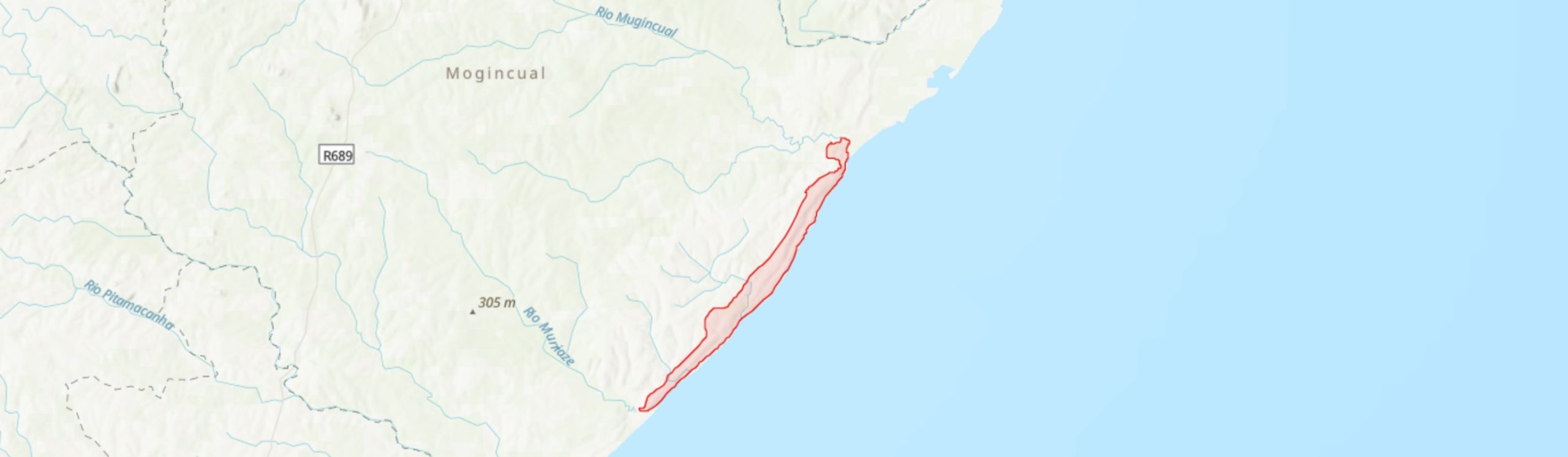
Central co-ordinates: 15.7355 S, 40.34300 E
Area: 63km²
Qualifying IPA Criteria
A(i)Site contains one or more globally threatened species, C(iii)Site contains nationally threatened or restricted habitat or vegetation types, AND/OR habitats that have severely declined in extent nationally
IPA assessment rationale
Quinga qualifies as an IPA under criterion A(i), containing globally important populations of three threatened species: Icuria dunensis (EN), Blepharis dunensis (EN) and Warneckea sessilicarpa (CR). It is the only site within the current IPA network in Mozambique to contain Blepharis dunensis and Quinga is considered likely to be a global stronghold for this species. Quinga also qualifies under criterion C(iii) as it contains up to 6 km2 of Rovuma Icuria-dominated coastal dry forest.
Site description
The Quinga IPA is located in coastal Liupo District of Nampula Province in northern Mozambique, between the latitudes of -15.85° and -15.60°. It comprises a stretch of ca. 37 km of coastline between the village of Quinga in the southwest to the estuary of the Mogincual River in the northeast, and extends inland for up to 3.5 km. This site contains some of the most intact coastal dune vegetation systems in Nampula Province and includes significant patches of well-preserved coastal dry forest. Whilst this area has been highly under-botanised to date, it is known to contain globally important populations of several threatened species and is very likely to prove to be one of the most important remaining sites in the southern portion of the proposed Rovuma Centre of Plant Endemism (CoE).
Botanical significance
The coastal dune formations between Quinga and the Mogincual River mouth support a number of rare and threatened species and habitats of the proposed Rovuma CoE (Burrows & Timberlake 2011; Darbyshire et al. 2019a). Quinga is believed to be a critical site for Blepharis dunensis, an Endangered local endemic of coastal northern Mozambique. This species has been recorded here at Quinga Beach growing in open dry dune scrub (A.R. Torre & J. Paiva #11439), and was recently re-recorded at this site (A. Massingue, pers. obs.). Given that the other two known localities for B. dunensis - Angoche and Pebane - are both now highly disturbed and with little intact dune vegetation remaining, the Quinga IPA may be the prime locality globally for this species (Darbyshire et al. 2019b).
This is also a globally important site for the endangered Icuria dunensis ('icuri' or 'ncuri') which forms mono-dominant or co-dominant dry forest stands. Several patches of Icuria forest have been confirmed within this IPA, including well preserved patches in the far north of the site along the margin of the Mogincual River Estuary which are reported to be in good condition (A. Massingue, pers. obs.; Darbyshire et al. 2019c). Whilst these forests have not been surveyed in full, a review of satellite imagery available on Google Earth Pro (2021) imagery suggests up to 6 km2 of forest containing Icuria may be present within the IPA, second only in area to the Moebase Icuria forests [MOZTIPA032].
The Critically Endangered shrub Warneckea sessilicarpa has recently been discovered here, where it was found to be locally common to dominant along the dunes at Quinga beach (A. Massingue, pers. obs.). Elsewhere within its narrow range, this species is associated with Icuria forest and so it is likely to occur in and around the Icuria patches of the Quinga IPA.
Other interesting species recorded at this site to date include the Mozambique endemics Dracaena (formerly Sansevieria) subspicata (not assessed but likely to be LC) and Chamaecrista paralias (LC). The Vulnerable shrub or climbing shrub Acacia (Senegalia) latistipulata may also occur here as it has been recorded from just outside the IPA boundary, along the route between Mogincual and Quinga (A.R. Torre & J. Paiva #11496). Given the highly incomplete botanical survey at this site to date, the likelihood of finding other rare species is high. This may include other species endemic to the southern portion of the Rovuma CoE, such as Scorodophloeus torrei (EN) and Ammannia moggii (CR). The latter of these is known to date only from the Angoche area, c. 50 km to the southwest of the Quinga IPA, and is Critically Endangered due to extensive sand mining operations there (Mucaleque 2020). This species should be sought for in the seasonal wetlands of the coastal dune systems at Quinga.
Habitat and geology
The vegetation of this site is a mosaic of coastal thicket, woodland and dry forest on coastal dune formations, together with extensive areas of seasonal wetlands and damp grasslands in the inter-dunal slacks. The coastal sands rich in heavy minerals including ilmenite (titanium ore) (Kenmare Resources 2018).The vegetation assemblages have not been studied in detail to date. As elsewhere within its range, the Icuria forests are associated with low-lying sands with a high water table. The coastal thicket vegetation is dominated by Sideroxylon inerme, Flacourtia indica and Mimosops cf.obovata (A. Massingue, pers. obs.); this is the “Dune Thicket-Forest [14b]” vegetation type of Burrows et al. (2018). Areas with better developed soils, e.g. along small rivers, support a woodland with Afzelia quanzensis and Millettia stuhlmannii amongst the dominant species (A. Massingue, pers. obs.). It is likely that the wooded areas on the inland side of the IPA include areas of miombo woodland.
The climate is highly seasonal, with a hot wet season from December to March/April, peaking in January. At nearby Mogincual to the north, annual rainfall is approximately 1,037 mm per year. Temperatures peak in December with an average high of 33°C (climatedata.eu).
Conservation issues
There is no formal protection or management for biodiversity within this IPA at present. Some of the woodland habitats are subject to continuing encroachment, particularly on the landward side of the IPA where smallholder farms increase in density moving inland, and there have been notable expansions of farmland clearly evident over the past 20 years from historical imagery available on Google Earth Pro (2021). However, there are still significant areas of intact habitats along the coastal strip and within the dune systems. At present, some of these areas are not visited frequently except by fishing communities. In such areas, the most likely threat is from fire which can encroach into these coastal habitats from the neighbouring agricultural lands inland; evidence of recent fires was observed to be widespread during surveys in 2017 (A. Massingue, pers. obs.). In the vicinity of Quinga, there is greater footfall around the beach, with much fishing activity and recreation, and this may impact the quality of the habitat. There is an urgent need to protect the remaining intact coastal habitats at this site, given their high botanical importance.
A significant future threat lies in the fact that a large portion of the IPA falls within the Quinga North mining concession for which an exploration license is held by Kenmare Resources plc. who operate the Moma Titanium Mineral Mine to the southwest. The Quinga North concession is believed to hold commercially viable concentrations of heavy minerals, including ilmenite, rutile and zircon. Reconnaissance exploration of this concession began in 2018 (Kenmare Resources 2018).
Ecosystem services
Although not surveyed in detail, the ecosystem services provided by this site are likely to be considerable. The dense thicket, woodland and forest vegetation helps to stabilise the dune systems which would otherwise be exposed to erosion from the Indian Ocean. These habitats are also likely to provide a range of provisioning services including building materials and fuelwood, although this requires more sustainable management. They also provide important habitat for a range of fauna, whilst the rich mosaic of habitats including the seasonal coastal wetlands are likely to be of importance for migrating birds.
Despite the extensive beaches and beautiful coastline, tourism potential at this site is considered to be low at present in view of its isolation - the main access is the road from Liupo to Quinga, a distance of c. 40 km.
Site assessor(s)
Iain Darbyshire, Royal Botanic Gardens, Kew
Alice Massingue, Universidade Eduardo Mondlane
IPA criterion A species
| Species | Qualifying sub-criterion | ≥ 1% of global population | ≥ 5% of national population | 1 of 5 best sites nationally | Entire global population | Socio-economically important | Abundance at site |
|---|---|---|---|---|---|---|---|
| Icuria dunensis Wieringa | A(i) |  |
|
|
 |
|
Occasional |
| Warneckea sessilicarpa (A.Fern. & R.Fern.) Jacq.-Fel. | A(i) | |
|
|
|
|
Frequent |
| Blepharis dunensis Vollesen | A(i) | |
|
|
|
|
Unknown |
Icuria dunensis Wieringa
Qualifying sub-criterion:
A(i)
≥ 1% of global population:
≥ 5% of national population:
1 of 5 best sites nationally:
Entire global population:
Socio-economically important:
Abundance at site:
Occasional
Warneckea sessilicarpa (A.Fern. & R.Fern.) Jacq.-Fel.
Qualifying sub-criterion:
A(i)
≥ 1% of global population:
≥ 5% of national population:
1 of 5 best sites nationally:
Entire global population:
Socio-economically important:
Abundance at site:
Frequent
Blepharis dunensis Vollesen
Qualifying sub-criterion:
A(i)
≥ 1% of global population:
≥ 5% of national population:
1 of 5 best sites nationally:
Entire global population:
Socio-economically important:
Abundance at site:
Unknown
IPA criterion C qualifying habitats
| Habitat | Qualifying sub-criterion | ≥ 5% of national resource | ≥ 10% of national resource | 1 of 5 best sites nationally | Areal coverage at site |
|---|---|---|---|---|---|
| Rovuma Icuria Coastal Dry Forest | C(iii) | |
|
|
5.8 |
Rovuma Icuria Coastal Dry Forest
Qualifying sub-criterion:
C(iii)
≥ 5% of national resource:
≥ 10% of national resource:
Areal coverage at site:
5.8
General site habitats
| General site habitat | Percent coverage | Importance |
|---|---|---|
| Forest - Subtropical/Tropical Dry Forest | |
Major |
| Savanna - Moist Savanna | |
Major |
| Shrubland - Subtropical/Tropical Dry Shrubland | |
Major |
| Marine Coastal/Supratidal - Coastal Sand Dunes | |
Major |
| Marine Coastal/Supratidal - Coastal Brackish/Saline Lagoons/Marine Lakes | |
Minor |
| Wetlands (inland) - Seasonal/Intermittent Freshwater Marshes/Pools [under 8 ha] | |
Major |
| Grassland - Subtropical/Tropical Seasonally Wet/Flooded Lowland Grassland | |
Major |
| Artificial - Terrestrial - Arable Land | |
Minor |
| Marine Intertidal - Sandy Shoreline and/or Beaches, Sand Bars, Spits, etc. | |
Minor |
Forest - Subtropical/Tropical Dry Forest
Percent coverage:
Importance:
Major
Savanna - Moist Savanna
Percent coverage:
Importance:
Major
Shrubland - Subtropical/Tropical Dry Shrubland
Percent coverage:
Importance:
Major
Marine Coastal/Supratidal - Coastal Sand Dunes
Percent coverage:
Importance:
Major
Marine Coastal/Supratidal - Coastal Brackish/Saline Lagoons/Marine Lakes
Percent coverage:
Importance:
Minor
Wetlands (inland) - Seasonal/Intermittent Freshwater Marshes/Pools [under 8 ha]
Percent coverage:
Importance:
Major
Grassland - Subtropical/Tropical Seasonally Wet/Flooded Lowland Grassland
Percent coverage:
Importance:
Major
Artificial - Terrestrial - Arable Land
Percent coverage:
Importance:
Minor
Marine Intertidal - Sandy Shoreline and/or Beaches, Sand Bars, Spits, etc.
Percent coverage:
Importance:
Minor
Land use types
| Land use type | Percent coverage | Importance |
|---|---|---|
| Agriculture (arable) | |
Minor |
| Agriculture (aquatic) | |
Major |
| Tourism / Recreation | |
Minor |
| Harvesting of wild resources | |
Unknown |
Agriculture (arable)
Percent coverage:
Importance:
Minor
Agriculture (aquatic)
Percent coverage:
Importance:
Major
Tourism / Recreation
Percent coverage:
Importance:
Minor
Harvesting of wild resources
Percent coverage:
Importance:
Unknown
Threats
| Threat | Severity | Timing |
|---|---|---|
| Agriculture & aquaculture - Annual & perennial non-timber crops - Small-holder farming | Medium | Ongoing - increasing |
| Biological resource use - Logging & wood harvesting | Medium | Ongoing - trend unknown |
| Natural system modifications - Fire & fire suppression - Increase in fire frequency/intensity | Unknown | Ongoing - trend unknown |
| Energy production & mining - Mining & quarrying | Unknown | Future - inferred threat |
Agriculture & aquaculture - Annual & perennial non-timber crops - Small-holder farming
Severity:
Medium
Timing:
Ongoing - increasing
Biological resource use - Logging & wood harvesting
Severity:
Medium
Timing:
Ongoing - trend unknown
Natural system modifications - Fire & fire suppression - Increase in fire frequency/intensity
Severity:
Unknown
Timing:
Ongoing - trend unknown
Energy production & mining - Mining & quarrying
Severity:
Unknown
Timing:
Future - inferred threat
Management type
| Management type | Description | Year started | Year finished |
|---|---|---|---|
| No management plan in place | |
|
No management plan in place
Year started:
Year finished:
Bibliography
Icuria dunensis. The IUCN Red List of Threatened Species 2019: e.T136532836A136538183.
The IUCN Red List of Threatened Species Available online
The endemic plants of Mozambique: diversity and conservation status
PhytoKeys, Vol 136, page(s) 45-96 Available online
Trees and Shrubs Mozambique
Google Earth Satellite Imagery
Mozambique’s centres of endemism, with special reference to the Rovuma Centre of Endemism of NE Mozambique and SE Tanzania.
South African Journal of Botany, Vol 77, page(s) 518
Kenmare Resources plc Annual Report and Accounts 2018.
Blepharis dunensis. The IUCN Red List of Threatened Species 2019: e.T120941013A120980068.
Ammannia moggii. The IUCN Red List of Threatened Species 2020: e.T149257990A153685939.


Recommended citation
Iain Darbyshire, Alice Massingue (2024) Tropical Important Plant Areas Explorer: Quinga (Mozambique). https://tipas.kew.org/site/quinga/ (Accessed on 27/07/2024)