Country: British Virgin Islands
Administrative region: Tortola (Province)
Central co-ordinates: 18.41797 N, 64.57421 W
Area: 0.43km²
Qualifying IPA Criteria
C(iii)Site contains nationally threatened or restricted habitat or vegetation types, AND/OR habitats that have severely declined in extent nationally
IPA assessment rationale
The area qualified as a TIPA under sub-criterion C(iii) for being the third-best site in the BVI for the nationally threatened Mangroves habitat. Coastal shrubland and Dry salt flats are nationally threatened habitats, but they did not qualify under sub-criterion C(iii) for this TIPA as other locations were more significant at a national level. No globally threatened or national high conservation importance species have been recorded within this TIPA.
Site description
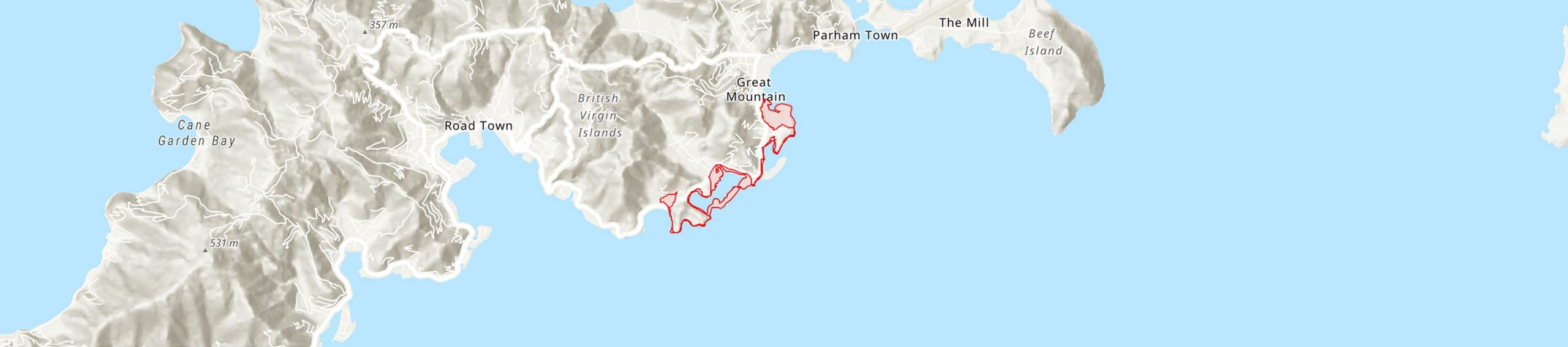
This TIPA runs from Bar Bay to Paraquita Bay along the coastal wetlands of south eastern Tortola, excluding urban developments and buildings. Both Paraquita Bay and Bar Bay are proposed terrestrial Habitat Management Areas in the BVI protected areas system plan 2007-2017.
Botanical significance
No globally threatened or national high conservation importance species have been recorded within this TIPA.
Habitat and geology
This is an important area for Mangroves habitat on Tortola and in the BVI. This is one of the nationally threatened habitats in the BVI, covering only 1.76km2 (1.13%) of the BVI’s land mass. Mangrove forest loss due to coastal development has been a problem not only in the BVI, but globally. A survey carried out by the BVI Conservation and Fisheries Department in 1990 identified 17 mangrove sites in the BVI that are of ecological and socioeconomic importance, and this included Paraquita Bay as a site of critical importance.
Conservation issues
The main threats to the TIPA are grazing by feral animals, pollution, climate change and future development. Problems that have been reported for Paraquita Bay and Paraquita Lagoon are garbage dumping, reclamation, pollution, development and logging. Storm surge and physical damage by winds and boats blown over during Hurricane Irma in 2017 caused extensive mangrove die off in the area, but recruitment is present and the area has been recovering naturally.
Ecosystem services
Paraquita Bay is managed by NPTVI as a hurricane shelter for boats as Paraquita Lagoon is almost surrounded by Mangroves, which can provide protection from storms and hurricanes. Mangroves also protect the marine environment from soil run-off during heavy rainfall, serve as nurseries for marine animals and provide habitat for birds. The Mangrove Boardwalk at the H. Lavity Stoutt Community College’s Marine Studies Centre located at Paraquita Bay can provide opportunities for ecotourism and community outreach.
Site assessor(s)
BVI TIPAs National Team, Royal Botanic Gardens, Kew - National Parks Trust of the Virgin Islands - BVI Ministry of Natural Resources, Labour and Immigration
IPA criterion C qualifying habitats
| Habitat | Qualifying sub-criterion | ≥ 5% of national resource | ≥ 10% of national resource | 1 of 5 best sites nationally | Areal coverage at site |
|---|---|---|---|---|---|
| Mangroves | C(iii) |  |
|
 |
Mangroves
Qualifying sub-criterion:
C(iii)
≥ 5% of national resource:
≥ 10% of national resource:
Areal coverage at site:
Bibliography
Identifying and Conserving Tropical Important Plant Areas in the British Virgin Islands (2016-2019): Final Technical Report


Recommended citation
BVI TIPAs National Team (2024) Tropical Important Plant Areas Explorer: Paraquita Bay and Bar Bay (British Virgin Islands). https://tipas.kew.org/site/paraquita-bay-and-bar-bay/ (Accessed on 27/07/2024)
Acknowledgement
Map of the BVI TIPAs Network available from ArcGIS Living Atlas of the World