Country: Uganda
Administrative region: Western (Region)
Central co-ordinates: 2.28245 N, 31.56369 E
Area: 5046km²
Qualifying IPA Criteria
A(i)Site contains one or more globally threatened species, B(iii)Site contains an exceptional number of socially, economically or culturally valuable species, C(iii)Site contains nationally threatened or restricted habitat or vegetation types, AND/OR habitats that have severely declined in extent nationally
IPA assessment rationale
Murchison-Karuma-Bugungu qualifies as an IPA under criterion A(i) as it supports at least 16 globally threatened species of plant. it is the only site in Uganda’s IPA network for Suddia sagittifolia and Aloe butiabana. It also qualifies under criterion B(iii) for its presence of 123 useful plant species, making up 11.8% of the national useful plant checklist. Significantly, the site contains 12% of the food species on the checklist, including Bridelia scleroneura. Additionally, five Crop Wild Relatives are known from this IPA: Dioscorea praehensilis, Dioscorea sagittifolia, Miscanthidium violaceum, Oryza punctata, and Sesamum angustifolium. Lastly, it triggers criterion C(iii), as it contains four nationally threatened habitats above the 3% threshold including Borassus palm woodland and wooded grassland (EN) habitat, Moist Combretum wooded grassland (EN), Vitex-Phyllanthus-Shirakipsis-Terminalia glaucescens woodland (VU), as well as dry Combretum wooded grassland (VU).
Site description
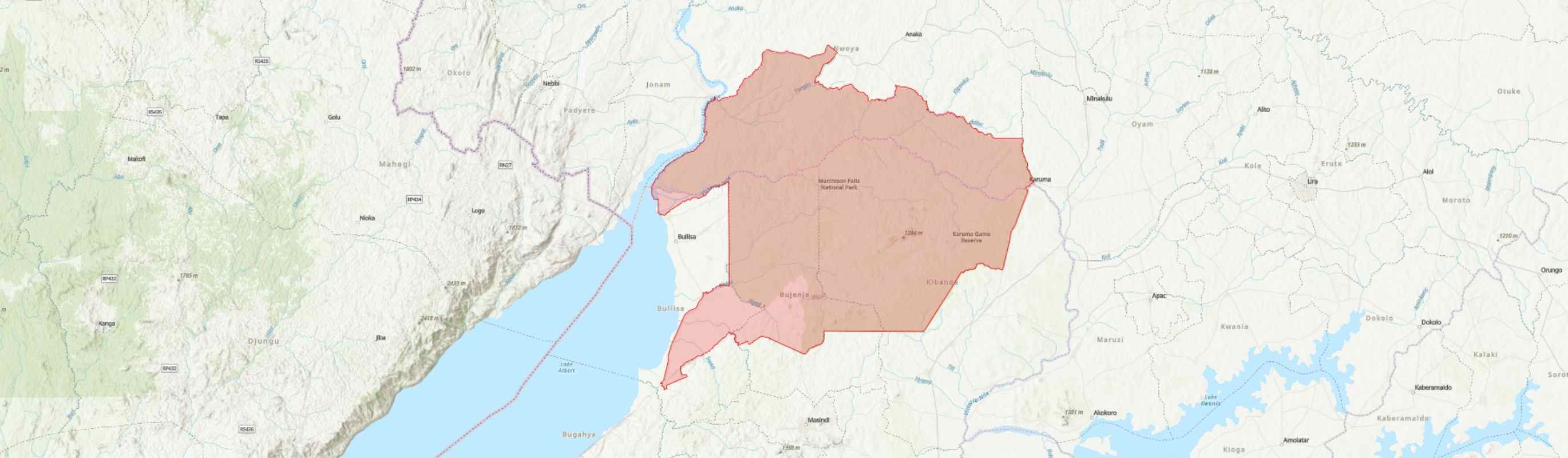
The Murchison-Karuma-Bugungu-Bugungu IPA, is the single largest protected area in Uganda, covering an area of 5,056+xxx km2 (UWA 2013). Murchison was gazetted as a Game Reserve in 1926, then as a National Park in 1952, and is now managed by UWA in conjunction with the two adjoining wildlife reserves (Karuma and Bugungu) under one general management plan (UWA 2013, UNEP-WCMC 2023). The IPA also includes the small part of the Ramsar Site which extends beyond the National Park boundary.
This IPA is situated in six districts of Nebbi to the north west, Nwoya to the north, Oyam to the north east, Buliisa to the south west, Masindi to the south, and Kiryandongo to the east. The first three districts are in the U1 floristic region in Northern while the rest are in U2 in Western Uganda. The IPA includes a Ramsar site which was designated in 2006, stretching from the top of the falls to the Delta (UWA 2013).
Murchison-Karuma-Bugungu- Bugungu IPA has the most powerful waterfalls in the world. It was considered a world-class tourist destination in the 1960s, but decades of war followed by instability caused by the Lord’s Resistance Army, operating in and around the northeast part of the park, resulting in massive declines in both tourist numbers and wildlife populations. Several wildlife populations have been recovering here over the past few decades (UWA 2017), including the critically endangered Rothschild’s giraffe (UWA 2013), and four of the five vulture species that occur regularly in MFNP are Critically Endangered (Pomeroy et al. 2023).
Botanical significance
Murchison-Karuma-Bugungu-Bugungu is a botanically important IPA, with at least 450 species of vascular plants from MFNP alone owing to a diversity of vegetation types (Kalema 2005). Balsamocitrus dawei Stapf, a globally Endangered species, is known to occur in Karuma Wildlife Reserve. Commelina zenkeri C.B.Clarke known from Karuma WR, is also globally Endangered. The Endangered Psilotrichum axilliflorum (Beentje 2017) is reported to occur at Bugungu WR, but this needs verification. The Murchison Falls-Albert Delta Wetland System Ramsar site of Murchison-Karuma-Bugungu-Bugungu IPA is the only site in Uganda where the range-restricted and globally Vulnerable Suddia sagittifolia is formally protected (Ali 2010). In Uganda, this species of swamp grass is otherwise only known from Masindi Port.
Afzelia africana (Hills 2020), Aloe butiabana (Baldwin et al. 2022), Cnestis mildbraedii (Amani et al. 2022), Entandrophragma cylindricum (Hawthorne 1998), Khaya anthotheca, Khaya grandifoliola (Hawthorne 1998), Ochna hackarsii (Gereau et al. 2019), Prunus africana (Hills & Cheek 2021), Rinorea beniensis (Amani et al. 2022b), Rinorea tshingandaensis (Ntore et al. 2021), Tricalysia bagshawei subsp. bagshawei (Amani et al. 2022a), Vitellaria paradoxa (Makerere University Institute of Environment and Natural Resources 1998) and Xylopia nilotica (Cosiaux et al. 2019), all globally vulnerable, also occur in the Murchison-Karuma-Bugungu IPA. Three species Mitragyna stipulosa, Dalbergia melanoxylon and Milicia excelsa (World Conservation Monitoring Centre, 1998) are not globally threatened but Near Threatened, hence warrant close monitoring in this IPA. Within the Murchison-Karuma-Bugungu IPA, Rabongo forest is particularly significant for Rinorea beniensis, R. tshingandaensis and Xylopia nilotica. The riverine forest along the Nile and its tributaries are important for Afzelia africana; Karuma WR for Entandrophragma cylindricum and Khaya anthotheca. The eroded gravelly hills around Paraa and Mubako, in undifferentiated thicket, are particularly important for Dalbergia melanoxylon. The dense woodlands south of the Nile are important for Vitellaria paradoxa which is found scattered in several places.
In the various vegetation types, a number of plant taxa which are rare in Uganda and even beyond are recorded, including Chasmopodium caudatum and Panicum phragmitoides, (Kalema 2003, 2005, 2006; Namaganda & Kalema 2003). In Uganda, C. caudatum has only been recorded from Murchison Falls National Park near Rabongo Forest (J. Kalema #2634) and Namukongo near R. Kafu (M. Namaganda #1017!) (Namaganda & Kalema 2003). Panicum phragmitoides is a very rare species of grass in Uganda, only recorded from MFNP (J. Kalema #2726!; Kalema 2003) though is known to be widespread in tropical Africa (Clayton 1972, 1989; POWO 2023). In Uganda, Cenchrus hohenackeri (Syn: Pennisetum hohenackeri) has a highly localised distribution, only known from Karuma WR, along Kafu River at Kafu and Aswa River (Kalema et al. 2016), hence only protected in Murchison-Karuma-Bugungu IPA. Bugungu WR is also important for the nationally Endangered but globally Least Concern tree Lovoa trichilioides (MTWA 2018).
The largest stands of Borassus aethiopum palm woodlands in Uganda are situated in the northern part of Murchison Falls National Park. This vegetation type has been assessed as nationally endangered, EN A1 (Richards et al. 2024). The Murchison-Karuma-Bugungu IPA is hence critical for the protection of this vegetation type in Uganda. The nationally threatened habitat of Dry Combretum Wooded Grassland is represented in this IPA. This vegetation type has been assessed as nationally vulnerable, VU A1 (Richards et al. 2024).
Habitat and geology
The Murchison-Karuma-Bugungu IPA is the main intact representation of the Sudanian regional centre of endemism in East Africa characterized by a mosaic of woodlands often dominated by Combretum and Acacia species. However, the composition and structure of vegetation have continued to change since the 1960s, largely due to influences of human and animal activities (Smart et al. 1985; Oneka 1996). Osmaston (1971) described eight vegetation categories for the area (dominated by Combretum woodlands), divided into 13 plant communities. In the southeast, the tropical high forest of Budongo, dominated by Cynometra alexandri and Celtis wightii, extends into the Rabongo Forest.
Following the near-elimination of elephants from the ecosystem, woodlands and thickets regenerated throughout the southern part of the IPA, and are characterised by Philenoptera laxiflora (Syn: Lonchocarpus laxiflorus), a preferred elephant food that has become the dominant species in the absence of browsing. Most woodlands on the south are now Terminalia-Combretum-Piliostigma with Philenoptera in the mid-storey (Kalema 2003, 2005; Namaganda & Kalema 2003) while Kigelia africana and Balanites aegyptiaca are notable tree species still thinly scattered over the savanna areas. Other common woodlands are Albizia-Acacia-Pseudocedrella, mixed with Stereospermum and Philenoptera, especially around Bugungu airstrip. At lower densities, these taxa form wooded grassland communities.
Throughout the wetter eastern and southern parts of the IPA, the grass layer is dominated by Hyperthelia dissoluta, Hyparrhenia filipendula and Loudetia arundinacea, plus fire climax species which grow to 1-3 m in the wet season, forming fuel for the hot fires which sweep through the IPA during most of the dry seasons. The open grasslands in the Buligi circuit are dominated by H. dissoluta, Sporobolus pyramidalis, Ctenium newtonii, and Eragrostis racemosa while Chloris gayana, Brachiaria brizantha, Andropogon schirensis, and Chamaecrista mimosoides are also abundant.
Thickets of Harissonia abyssinica, Combretum aculeatum, Acacia senegal, Euphorbia candelabrum and Cadaba farinosa are particularly common south of the Nile fringing the riverine vegetation, especially around Paraa and Mubako on easily eroded clayey soils. Marsdenia rubicunda is a frequent climber on the woody species, while species of Capparis are common scramblers. Succulent Sansevieria spp. are a common occurrence under the shade conditions of the tangle. Chloris gayana, Heteropogon contortus, Bothriochloa insculpta, Brachiaria spp. and H. dissoluta are usual species in the grass layer (Kalema 2011).
In the northern part of the IPA are large stands of Borassus aethiopum palm woodlands in Uganda, although elsewhere in Guinea-Congolian and Sudanian Africa they are more widespread (Kalema & Beentje 2012). Also in the north is the Pandero woodland, a unique relict community comprised of Terminalia schimperiana, Amblygnocarpus andongensis, Prosopis africana and Combretum adenogonium. However, following years of elephant and fire damage, most of the older Terminalia trees are dead, and are being replaced by Philenoptera. Woodlands dominated by Combretum molle and C. collinum with a sparse shrub layer and a thick ground cover of grasses including Brachiaria brizantha are also common south of the Nile.
Fringing the Nile is riverine forest, woodland and bushland. Riverine woodlands are commonly of Acacia polyacantha, A. sieberiana and Kigelia africana. Lannea - Vepris - Harissonia bushland with dense mixed thicket is common, especially on the southern banks of the river. Such dense bushlands are usually dominated by A. sieberiana, Lannea schweinfurthii, Vepris nobilis, Harissonia abyssinica and Gymnosporia (Syn: Maytenus) heterophylla, with a sparse herb layer including Sansevieria nilotica and Sporobolus pyramidalis.
The shallow valleys often support wetlands, both permanent and seasonal. The seasonally flooded areas are habitat for Echinochloa pyramidalis, Setaria sphacelata, Persicaria spp., Leersia hexandra, Urochloa sp. and often invaded by Mimosa pigra, often with occasional occurrence of Kigelia africana. Closer to the water are dense Cyperus papyrus and Phragmites mauritianum wetlands supporting the restricted Suddia sagittifolia in places closer to the delta.
Moving northwards from Bugungu WR, the Rift escarpment is less pronounced, and it disappears as a physical feature in northern MFNP, to reappear as an escarpment defining the east bank of the Albert Nile north of Pakwach. The park itself, with its rolling topography, is gently inclined from the highest point at Rabongo Hill in the east (1,291 m), to Lake Albert in the west (619 m).
The Murchison-Karuma-Bugungu IPA lies at the northern end of the Albertine Rift Valley, and takes in part of the valley floor, and part of the eastern escarpment above. The valley bottom is composed of sandy alluvial sediments, which are easily eroded, as is seen along the banks of the Nile below the Falls.
Above the escarpment, extending over the eastern part of the IPA is the original basement complex of gneisses and granites. These ancient rocks are deeply weathered, forming red loams of low or medium fertility. Nearer the Rift, much of this weathered rock has been stripped away, and the soils are shallow and poor. Many of the soils in the IPA are lateritic, rich in iron deposits either in the form of gravel or as solid ironstone (UWA 2013).
The climate of this IPA is hot and humid. The relative humidity averages 60% and the temperature ranges from a mean maximum of 29°C to a mean minimum of 22°C. The eastern end of the IPA is wetter than the west. Accordingly, Chobe receives some 1,500 mm, whilst Paraa receives about 1,100 mm per annum. The wet season used to run from March to November with a short dry spell in July but this seems to be changing (UWA 2013).
Conservation issues
Murchison was gazetted as a National Park in 1952, Karuma as a Game Reserve (now WR) in 1964 and Bugungu as a Game Reserve in 1968 (UWA 2013). This IPA is internationally recognized as an Important Bird Area (IBA), due to the presence of birds that are: a) globally threatened, b) of the Sudan and Guinea Savanna biome, c) of the Lake Victoria Basin, and d) congregatory (Byaruhanga et al. 2001). It is also a Key Biodiversity Area (KBA), having qualified as such on account of the presence of the globally Endangered Rothschild giraffe (Giraffa camelopardalis rothschildii), Vulnerable Giant pangolin (Smutsia gigantea), and Vulnerable Elephant (Loxodonta africana) (Plumptre et al. 2017).
The area stretching from the top of Murchison Falls to the Albert Delta was designated by the RAMSAR Bureau as a Ramsar Site (wetland of international importance) in 2006, the Murchison Falls-Albert Delta Wetland system Ramsar site (Ramsar site No. 1640). This Ramsar Site covers an area of 172.93 km2 (Byaruhanga et al. 2001) and lies predominantly within MFNP, although a small area along the southern edge is outside the park.
The range-restricted grass Suddia sagittifolia, only known from Uganda and South Sudan, occurs within the permanent wetlands of this IPA. These same wetlands are home to the endangered Shoebill (Balaeniceps rex), one of the few sites for this species nationally. This part of the ecologically sensitive zone, in addition to being an IBA. supports the last surviving viable populations of the Nile crocodile (Crocodylus niloticus) in Uganda. This section of the Nile is also a fish breeding zone that supports the sustained fisheries activities downstream into Lake Albert.
There are 109 mammal species, including one near-endemic species, five threatened species and 21 total IUCN Red-listed species requiring conservation measures and/or surveys or studies to further understand their status (Plumptre et al. 2010). There are 476 identified bird species in the IPA.
Animals, especially elephants, but also buffalos, hippos and crocodiles, often cross from the park into neighbouring communities, raiding their crops and livestock and sometimes causing human injury and death. This has bred human-wildlife conflicts and communities developing resentment for the park and wildlife (UWA 2013).
Most local residents surrounding the IPA engage in smallholder farming and cattle herding, although fishing is the primary livelihood at the confluence of Lake Albert and the Nile River. In the southwestern section of the IPA, there is frequent illegal cattle grazing by the indigenous Bagungu and immigrant pastoral communities, especially in Bugungu WR where the communities are literally living on a narrow strip of land between Lake Albert and the reserve. Cattle grazing in the last five years has led to marked degradation (UWA 2013). Tobacco farming in the south section of the park also increases the demand for fuel wood to cure tobacco. Charcoal burning is observed in places such as Nyakarongo, Kituka, Nyamahasa, Acimi and Adebuk. The increased demand for charcoal and lack of alternative sources of energy is causing more degradation in the neighbouring Budongo forest and the adjoining areas of the Park. Wildlife crime, the illegal use of wild living resources, is a significant threat to the IPA’s wild flora and fauna, but also worsens human-wildlife conflicts (UWA 2017).
The human-wildlife conflicts are also heightened by unclear and unmarked boundary sections of the MFNP. Some sections of the boundary were not marked due to unresolved conflicts with local communities. These areas include Wanseko, Agung, Adibuk, Pinoyago, Kichumbanyobo and Ogelo. Buoys that had been placed along the delta boundary section were destroyed by fishermen (UWA 2013). Encroachment has been recorded at Ogelo with six families living inside the national park. At Kinchumbanyobo gate in the south, one family is resident inside the national park as a result of erroneously shifting the boundary line (UWA 2013).
A number of alien invasive plant species have continued to spread in the IPA. One of the most notorious of these is Chromolaena odorata, a shrub which has spread especially south of the Nile and the track to the top of the falls north of the Nile. Others are M. pigra in wetland areas including the animal wallow areas, and Lantana camara which is very abundant in parts of Karuma WR, especially along Nanda Road where it forms dense impenetrable thickets. Along the Nile and other waterways are Eichhornia crassipes (Water Hyacinth) and Salvinia molesta (Kariba Weed). These two aquatic introductions have the potential to invade all the water ways within the IPA. There is need to map the extent and monitor the spread of all the invasive species in the park and surrounding areas to design management strategies.
Oil was first discovered in western Uganda in the 1870s, but commercially viable amounts were only confirmed in 2006 (Rwakakamba & Lukwago 2013). Oil fields are contained partially or completely within the park boundaries (PEPD 2014). Although petroleum resources have a great potential to cause national development and improve community livelihoods, the exploration and production activities have several associated negative impacts especially when located within sensitive ecosystems. These impacts include but are not limited to: vegetation clearance and land take due to the establishment of drill sites, camps, seismic surveys, drilling and road networks; habitat/niche destruction; increased human and vehicular traffic; noise from heavy machinery; and alteration in animal behaviour, distribution, and ranging. In addition, oil activities could result in pollution due to hazardous wastes causing deterioration in the environmental quality. The drill wastes (mud cuttings and drill wastewater) have been tested and found to contain heavy metals namely Cadmium, Nickel, Lead and Mercury in quantities that are above the standard permissible levels.
Oil extraction within this IPA presents particular risks to the continued recovery of many species decimated by past decades of conflict (Plumptre et al. 2007). Oil and gas flaring, production spills, burst pipelines, and tanker spills may damage biodiversity, devastate the habitats through contamination, and cause loss of livelihoods (MacKenzie et al. 2017, Pomeroy et al. 2023).
A number of hydroelectric power development projects have been proposed along the Nile. Works are nearly complete at Karuma, and others are likely to occur further downstream inside the IPA. Ayago hydropower project commenced with feasibility studies and a full Environmental and Social Impact Assessment. This project will be located entirely inside the IPA. The impacts of this project are anticipated to be enormous, especially during the construction phase of the power plant. The impacts will include vegetation removal and compaction, access road opening, trucks carrying materials, waste management, noise pollution through rock blasting, possible accidental road kills, and large numbers of workers inside the IPA that could lead to poaching, among others. Once power has been generated at Ayago, high-voltage transmission lines will have to be constructed inside the IPA to evacuate the electricity, with the associated impacts on both flora and fauna.
Wildfires are set in this entire IPA at the beginning of dry seasons. Poachers set early fires to encourage the growth of young green and lush vegetation that can attract wild animals to the park periphery for easy trapping. Park Management also practices early burning as a management tool before the vegetation completely dries out to avoid hot fires that devastate the vegetation. Accidental fires also occasionally occur by visitors, for example from cigarette stubs thrown on the ground. The frequent occurrence of fire is suspected to be a cause of vegetation change in the IPA; burning is reported to be affecting the quality of habitat. On the northern section of the IPA, the Pandero woodlands dominated by Terminalia species are gradually dying back, although the cause is not clear. There is no fire management plan in place to guide more appropriate and effective burning to avert negative ecological changes.
Ecosystem services
The Murchison-Karuma-Bugungu IPA is a critical biodiversity site within the region of intensive pastoral activity, fishing and some cultivation. The IPA plays important roles of provisioning, regulatory and supporting services in the general landscape, with water from the Nile being a critical resource for community livelihood and their socio-economic activities.
Murchison-Karuma-Bugungu IPA is a significant reservoir of resources that are of direct and indirect socio-economic benefit to the surrounding communities. Utilised sustainably, these resources could contribute to the improvement of livelihood and poverty eradication. The river and stream systems in the IPA provide feeding and watering services for wildlife in the area during the dry season and are also of social and cultural importance to the people living in the area as a source of water for domestic use and fishing. The local communities are mainly engaged in fishing from the Lake Albert and Delta areas. There is some illegal local hunting for bushmeat and harvesting of plants for medicinal purposes.
There are also tourism facilities that are adjacent to the Protected Area. MFNP receives over 60,000 visitors per year owing to its scenic beauty, as well as the exceptional biodiversity (UWA 2023). As a result, many tourism facilities, especially lodges, have been developed adjacent to the Protected Area, contributing immensely to the income of the developers. The wetlands of the Delta play an important function in water filtration, improving water quality for use further downstream.
Site assessor(s)
Assessed by:
James Kalema, Makerere University Herbarium
Kennedy Mukasa, Makerere University Herbarium
Samuel Ojelel, Makerere University Herbarium
Haley Gladitsch, Royal Botanic Gardens, Kew
Florence O'Sullivan, Royal Botanic Gardens, Kew
Date of first assessment: 13th Nov 2024
Reviewed by:Micheal Kibuule, Nature Uganda
IPA criterion A species
| Species | Qualifying sub-criterion | ≥ 1% of global population | ≥ 5% of national population | 1 of 5 best sites nationally | Entire global population | Socio-economically important | Abundance at site |
|---|---|---|---|---|---|---|---|
| Balsamocitrus dawei Stapf | A(i) |  |
 |
|
|
|
Occasional |
| Commelina zenkeri C.B.Clarke | A(i) | |
|
|
|
|
Unknown |
| Afzelia africana Sm. ex Pers. | A(i) | |
|
|
|
|
Occasional |
| Vitellaria paradoxa C.F.Gaertn. | A(i) | |
|
|
|
|
Occasional |
| Entandrophragma cylindricum (Sprague) Sprague | A(i) | |
|
|
|
|
Occasional |
| Khaya anthotheca (Welw.) C.DC. | A(i) | |
|
|
|
|
Occasional |
| Aloe butiabana T.C.Cole & T.G.Forrest | A(i) | |
|
|
|
|
Occasional |
| Suddia sagittifolia Renvoize | A(i) | |
|
|
|
|
Unknown |
| Tricalysia bagshawei S.Moore subsp. bagshawei | A(i) | |
|
|
|
|
Unknown |
| Rinorea beniensis Engl. | A(i) | |
|
|
|
|
Occasional |
| Rinorea tshingandaensis Taton | A(i) | |
|
|
|
|
Scarce |
| Xylopia nilotica D.M.Johnson & N.A.Murray | A(i) | |
|
|
|
|
Scarce |
| Ochna hackarsii Robyns & Lawalrée | A(i) | |
|
|
|
|
Occasional |
| Cnestis mildbraedii Gilg | A(i) | |
|
|
|
|
Occasional |
| Khaya grandifoliola C.DC. | A(i) | |
|
|
|
|
Occasional |
Balsamocitrus dawei Stapf
Qualifying sub-criterion:
A(i)
≥ 1% of global population:
≥ 5% of national population:
1 of 5 best sites nationally:
Entire global population:
Socio-economically important:
Abundance at site:
Occasional
Commelina zenkeri C.B.Clarke
Qualifying sub-criterion:
A(i)
≥ 1% of global population:
≥ 5% of national population:
1 of 5 best sites nationally:
Entire global population:
Socio-economically important:
Abundance at site:
Unknown
Afzelia africana Sm. ex Pers.
Qualifying sub-criterion:
A(i)
≥ 1% of global population:
≥ 5% of national population:
1 of 5 best sites nationally:
Entire global population:
Socio-economically important:
Abundance at site:
Occasional
Vitellaria paradoxa C.F.Gaertn.
Qualifying sub-criterion:
A(i)
≥ 1% of global population:
≥ 5% of national population:
1 of 5 best sites nationally:
Entire global population:
Socio-economically important:
Abundance at site:
Occasional
Entandrophragma cylindricum (Sprague) Sprague
Qualifying sub-criterion:
A(i)
≥ 1% of global population:
≥ 5% of national population:
1 of 5 best sites nationally:
Entire global population:
Socio-economically important:
Abundance at site:
Occasional
Khaya anthotheca (Welw.) C.DC.
Qualifying sub-criterion:
A(i)
≥ 1% of global population:
≥ 5% of national population:
1 of 5 best sites nationally:
Entire global population:
Socio-economically important:
Abundance at site:
Occasional
Aloe butiabana T.C.Cole & T.G.Forrest
Qualifying sub-criterion:
A(i)
≥ 1% of global population:
≥ 5% of national population:
1 of 5 best sites nationally:
Entire global population:
Socio-economically important:
Abundance at site:
Occasional
Suddia sagittifolia Renvoize
Qualifying sub-criterion:
A(i)
≥ 1% of global population:
≥ 5% of national population:
1 of 5 best sites nationally:
Entire global population:
Socio-economically important:
Abundance at site:
Unknown
Tricalysia bagshawei S.Moore subsp. bagshawei
Qualifying sub-criterion:
A(i)
≥ 1% of global population:
≥ 5% of national population:
1 of 5 best sites nationally:
Entire global population:
Socio-economically important:
Abundance at site:
Unknown
Rinorea beniensis Engl.
Qualifying sub-criterion:
A(i)
≥ 1% of global population:
≥ 5% of national population:
1 of 5 best sites nationally:
Entire global population:
Socio-economically important:
Abundance at site:
Occasional
Rinorea tshingandaensis Taton
Qualifying sub-criterion:
A(i)
≥ 1% of global population:
≥ 5% of national population:
1 of 5 best sites nationally:
Entire global population:
Socio-economically important:
Abundance at site:
Scarce
Xylopia nilotica D.M.Johnson & N.A.Murray
Qualifying sub-criterion:
A(i)
≥ 1% of global population:
≥ 5% of national population:
1 of 5 best sites nationally:
Entire global population:
Socio-economically important:
Abundance at site:
Scarce
Ochna hackarsii Robyns & Lawalrée
Qualifying sub-criterion:
A(i)
≥ 1% of global population:
≥ 5% of national population:
1 of 5 best sites nationally:
Entire global population:
Socio-economically important:
Abundance at site:
Occasional
Cnestis mildbraedii Gilg
Qualifying sub-criterion:
A(i)
≥ 1% of global population:
≥ 5% of national population:
1 of 5 best sites nationally:
Entire global population:
Socio-economically important:
Abundance at site:
Occasional
Khaya grandifoliola C.DC.
Qualifying sub-criterion:
A(i)
≥ 1% of global population:
≥ 5% of national population:
1 of 5 best sites nationally:
Entire global population:
Socio-economically important:
Abundance at site:
Occasional
IPA criterion C qualifying habitats
| Habitat | Qualifying sub-criterion | ≥ 5% of national resource | ≥ 10% of national resource | 1 of 5 best sites nationally | Areal coverage at site |
|---|---|---|---|---|---|
| Dry Combretum wooded grassland (VU) | C(iii) | |
|
|
855.28 |
| Moist Combretum wooded grassland (EN) | C(iii) | |
|
|
718.55 |
| Vitex-Phyllanthus-Shirakipsis (Sapium)-Terminalia and Terminalia glaucescens woodland (VU) | C(iii) | |
|
|
1227 |
| Palm wooded grassland (EN) | C(iii) | |
|
|
35.57 |
| Freshwater marshes (VU) | C(iii) | |
|
|
38.43 |
| Medium Altitude Semi-Deciduous Forest (EN) | C(iii) | |
|
|
39.69 |
Dry Combretum wooded grassland (VU)
Qualifying sub-criterion:
C(iii)
≥ 5% of national resource:
≥ 10% of national resource:
Areal coverage at site:
855.28
Moist Combretum wooded grassland (EN)
Qualifying sub-criterion:
C(iii)
≥ 5% of national resource:
≥ 10% of national resource:
Areal coverage at site:
718.55
Vitex-Phyllanthus-Shirakipsis (Sapium)-Terminalia and Terminalia glaucescens woodland (VU)
Qualifying sub-criterion:
C(iii)
≥ 5% of national resource:
≥ 10% of national resource:
Areal coverage at site:
1227
Palm wooded grassland (EN)
Qualifying sub-criterion:
C(iii)
≥ 5% of national resource:
≥ 10% of national resource:
Areal coverage at site:
35.57
Freshwater marshes (VU)
Qualifying sub-criterion:
C(iii)
≥ 5% of national resource:
≥ 10% of national resource:
Areal coverage at site:
38.43
Medium Altitude Semi-Deciduous Forest (EN)
Qualifying sub-criterion:
C(iii)
≥ 5% of national resource:
≥ 10% of national resource:
Areal coverage at site:
39.69
General site habitats
| General site habitat | Percent coverage | Importance |
|---|---|---|
| Forest - Subtropical/Tropical Moist Lowland Forest | |
Minor |
| Savanna - Dry Savanna | 55 | Major |
| Grassland - Subtropical/Tropical Dry Lowland Grassland | 25 | Major |
| Wetlands (inland) - Permanent Rivers, Streams, Creeks [includes waterfalls] | 10 | Major |
| Wetlands (inland) - Seasonal/Intermittent/Irregular Rivers, Streams, Creeks | |
|
| Wetlands (inland) - Permanent Freshwater Lakes [over 8 ha] | 1 | Minor |
| Wetlands (inland) - Seasonal/Intermittent Freshwater Lakes [over 8 ha] | 10 | Major |
| Wetlands (inland) - Seasonal/Intermittent Freshwater Marshes/Pools [under 8 ha] | |
|
| Wetlands (inland) - Permanent Inland Deltas | |
|
| Rocky Areas - Rocky Areas [e.g. inland cliffs, mountain peaks] | |
|
| Grassland - Subtropical/Tropical Seasonally Wet/Flooded Lowland Grassland | |
Minor |
Forest - Subtropical/Tropical Moist Lowland Forest
Percent coverage:
Importance:
Minor
Savanna - Dry Savanna
Percent coverage:
55
Importance:
Major
Grassland - Subtropical/Tropical Dry Lowland Grassland
Percent coverage:
25
Importance:
Major
Wetlands (inland) - Permanent Rivers, Streams, Creeks [includes waterfalls]
Percent coverage:
10
Importance:
Major
Wetlands (inland) - Seasonal/Intermittent/Irregular Rivers, Streams, Creeks
Percent coverage:
Importance:
Wetlands (inland) - Permanent Freshwater Lakes [over 8 ha]
Percent coverage:
1
Importance:
Minor
Wetlands (inland) - Seasonal/Intermittent Freshwater Lakes [over 8 ha]
Percent coverage:
10
Importance:
Major
Wetlands (inland) - Seasonal/Intermittent Freshwater Marshes/Pools [under 8 ha]
Percent coverage:
Importance:
Wetlands (inland) - Permanent Inland Deltas
Percent coverage:
Importance:
Rocky Areas - Rocky Areas [e.g. inland cliffs, mountain peaks]
Percent coverage:
Importance:
Grassland - Subtropical/Tropical Seasonally Wet/Flooded Lowland Grassland
Percent coverage:
Importance:
Minor
Land use types
| Land use type | Percent coverage | Importance |
|---|---|---|
| Nature conservation | 100 | Major |
| Tourism / Recreation | 35 | Major |
| Harvesting of wild resources | |
Minor |
| Extractive industry | 10 | Major |
| Agriculture (pastoral) | |
Nature conservation
Percent coverage:
100
Importance:
Major
Tourism / Recreation
Percent coverage:
35
Importance:
Major
Harvesting of wild resources
Percent coverage:
Importance:
Minor
Extractive industry
Percent coverage:
10
Importance:
Major
Agriculture (pastoral)
Percent coverage:
Importance:
Threats
| Threat | Severity | Timing |
|---|---|---|
| Residential & commercial development - Tourism & recreation areas | Low | Ongoing - increasing |
| Energy production & mining - Oil & gas drilling | Medium | Ongoing - increasing |
| Energy production & mining - Renewable energy | Medium | Future - inferred threat |
| Transportation & service corridors - Roads & railroads | Medium | Ongoing - stable |
| Transportation & service corridors - Utility & service lines | Low | Ongoing - increasing |
| Transportation & service corridors - Flight paths | Low | Ongoing - stable |
| Biological resource use - Gathering terrestrial plants - Intentional use (species being assessed is the target) | Low | Ongoing - stable |
| Biological resource use - Logging & wood harvesting - Intentional use: subsistence/small scale (species being assessed is the target) [harvest] | Low | Ongoing - stable |
| Biological resource use - Fishing & harvesting aquatic resources - Unintentional effects: subsistence/small scale (species being assessed is not the target) [harvest] | Medium | Ongoing - increasing |
| Human intrusions & disturbance - Recreational activities | Low | Ongoing - increasing |
| Human intrusions & disturbance - Work & other activities | Low | Ongoing - increasing |
| Natural system modifications - Fire & fire suppression - Increase in fire frequency/intensity | Medium | Ongoing - stable |
| Invasive & other problematic species, genes & diseases - Invasive non-native/alien species/diseases | High | Ongoing - increasing |
| Agriculture & aquaculture - Livestock farming & ranching - Small-holder grazing, ranching or farming | Medium | Ongoing - increasing |
Residential & commercial development - Tourism & recreation areas
Severity:
Low
Timing:
Ongoing - increasing
Energy production & mining - Oil & gas drilling
Severity:
Medium
Timing:
Ongoing - increasing
Energy production & mining - Renewable energy
Severity:
Medium
Timing:
Future - inferred threat
Transportation & service corridors - Roads & railroads
Severity:
Medium
Timing:
Ongoing - stable
Transportation & service corridors - Utility & service lines
Severity:
Low
Timing:
Ongoing - increasing
Transportation & service corridors - Flight paths
Severity:
Low
Timing:
Ongoing - stable
Biological resource use - Gathering terrestrial plants - Intentional use (species being assessed is the target)
Severity:
Low
Timing:
Ongoing - stable
Biological resource use - Logging & wood harvesting - Intentional use: subsistence/small scale (species being assessed is the target) [harvest]
Severity:
Low
Timing:
Ongoing - stable
Biological resource use - Fishing & harvesting aquatic resources - Unintentional effects: subsistence/small scale (species being assessed is not the target) [harvest]
Severity:
Medium
Timing:
Ongoing - increasing
Human intrusions & disturbance - Recreational activities
Severity:
Low
Timing:
Ongoing - increasing
Human intrusions & disturbance - Work & other activities
Severity:
Low
Timing:
Ongoing - increasing
Natural system modifications - Fire & fire suppression - Increase in fire frequency/intensity
Severity:
Medium
Timing:
Ongoing - stable
Invasive & other problematic species, genes & diseases - Invasive non-native/alien species/diseases
Severity:
High
Timing:
Ongoing - increasing
Agriculture & aquaculture - Livestock farming & ranching - Small-holder grazing, ranching or farming
Severity:
Medium
Timing:
Ongoing - increasing
Protected areas
| Protected area name | Protected area type | Relationship with IPA | Areal overlap |
|---|---|---|---|
| Murchison Falls National Park | National Park | IPA encompasses protected/conservation area | 3878 |
| Karuma Wildlife Reserve | Wildlife Reserve | IPA encompasses protected/conservation area | 675 |
| Budongo Wildlife Reserve | Wildlife Reserve | protected/conservation area overlaps with IPA | 228 |
| Bugungu Wildlife Reserve | Wildlife Reserve | IPA encompasses protected/conservation area | 333 |
Murchison Falls National Park
Protected area type:
National Park
Relationship with IPA:
IPA encompasses protected/conservation area
Areal overlap:
3878
Karuma Wildlife Reserve
Protected area type:
Wildlife Reserve
Relationship with IPA:
IPA encompasses protected/conservation area
Areal overlap:
675
Budongo Wildlife Reserve
Protected area type:
Wildlife Reserve
Relationship with IPA:
protected/conservation area overlaps with IPA
Areal overlap:
228
Bugungu Wildlife Reserve
Protected area type:
Wildlife Reserve
Relationship with IPA:
IPA encompasses protected/conservation area
Areal overlap:
333
Conservation designation
| Designation name | Protected area | Relationship with IPA | Areal overlap |
|---|---|---|---|
| Murchison Falls – Albert Delta Wetland System Ramsar | Ramsar | protected/conservation area overlaps with IPA | 172 |
| Murchison Falls National Park | Key Biodiversity Area | protected/conservation area matches IPA | 3878 |
| Murchison Falls National Park | Important Bird Area | protected/conservation area matches IPA | 3878 |
| Bugungu Wildlife Reserve | Key Biodiversity Area | IPA encompasses protected/conservation area | 473 |
| Budongo Wildlife Reserve | Important Bird Area | IPA encompasses protected/conservation area | 232 |
| Budongo Wildlife Reserve | Key Biodiversity Area | IPA encompasses protected/conservation area | 232 |
| Karuma Wildlife Reserve | Key Biodiversity Area | IPA encompasses protected/conservation area | 541 |
Murchison Falls – Albert Delta Wetland System Ramsar
Protected area:
Ramsar
Relationship with IPA:
protected/conservation area overlaps with IPA
Areal overlap:
172
Murchison Falls National Park
Protected area:
Key Biodiversity Area
Relationship with IPA:
protected/conservation area matches IPA
Areal overlap:
3878
Murchison Falls National Park
Protected area:
Important Bird Area
Relationship with IPA:
protected/conservation area matches IPA
Areal overlap:
3878
Bugungu Wildlife Reserve
Protected area:
Key Biodiversity Area
Relationship with IPA:
IPA encompasses protected/conservation area
Areal overlap:
473
Budongo Wildlife Reserve
Protected area:
Important Bird Area
Relationship with IPA:
IPA encompasses protected/conservation area
Areal overlap:
232
Budongo Wildlife Reserve
Protected area:
Key Biodiversity Area
Relationship with IPA:
IPA encompasses protected/conservation area
Areal overlap:
232
Karuma Wildlife Reserve
Protected area:
Key Biodiversity Area
Relationship with IPA:
IPA encompasses protected/conservation area
Areal overlap:
541
Management type
| Management type | Description | Year started | Year finished |
|---|---|---|---|
| Site management plan in place | General Management Plan | 2012 | 2022 |
Site management plan in place
General Management Plan
Year started:
2012
Year finished:
2022
Bibliography
Khaya anthotheca. The IUCN Red List of Threatened Species 1998: e.T32235A9690061
Dalbergia melanoxylon. The IUCN Red List of Threatened Species 2020: e.T32504A67798379.
A revision of Xylopia L. (Annonaceae): the species of Tropical Africa.
PhytoKeys, Vol 97, page(s) 1-252
Conservation Checklist of the Trees of Uganda
Cnestis mildbraedii. The IUCN Red List of Threatened Species 2022: e.T154236655A154387921.
Khaya grandifoliola. The IUCN Red List of Threatened Species 1998: e.T32172A9684738.
Afzelia africana. The IUCN Red List of Threatened Species 2020: e.T33032A67742420.
Distribution, habitat and conservation of range-restricted species of the genera Eleusine Gaertn. and Pennisetum Rich. (Poaceae) in Uganda.
Symbolae Botanicae Upsalienses, Vol 38, page(s) 93-100
Diversity and distribution of vascular plants in wetland and savanna Important Bird Areas of Uganda.
Important Bird Areas in Uganda.
Suddia sagittifolia. The IUCN Red List of Threatened Species 2010: e.T185225A8370624
Tricalysia bagshawei subsp. bagshawei. The IUCN Red List of Threatened Species 2022: e.T154349304A154388276
Rinorea beniensis. The IUCN Red List of Threatened Species 2022: e.T153249836A153256016
Aloe butiabana. The IUCN Red List of Threatened Species 2022: e.T110696681A110696694.
Gramineae in Flora of West Tropical Africa 2nd ed. (ed. F.N. Hepper)
Flora Zambesiaca (ed. E. Launert & G.V. Pope)
Xylopia nilotica. The IUCN Red List of Threatened Species 2019: e.T137097225A137112214
Entandrophragma cylindricum. The IUCN Red List of Threatened Species 1998: e.T33051A9753619
Mitragyna stipulosa. The IUCN Red List of Threatened Species 2021: e.T33913A147040644.
The significance of Important Bird Areas for conservation of plants in Uganda. In: S.A. Ghazanfar & H.J. Beentje (eds)
Taxonomy and Ecology of African Plants, their Conservation and Sustainable Use (pub. Royal Botanic Gardens, Kew), page(s) 457-472
The vegetation and flora of Jobi Rii and Jobi East and Mpyo Block of Murchison Falls National Park for baseline studies for a proposed 3D seismic survey
Unpublished report submitted to ERM/BIMCO for EIA.
Plants of The World Online: Panicum phragmitoides Stapf
Farmers in Uganda’s oil economy: deal or no deal!
Protected Area Profile for Murchison Falls from the World Database on Protected Areas, November 2023
Murchison Falls National Park Karuma Wildlife Reseve Bugungu Wildlife Reserve (Murchison Falls Protected Area) General Management Plan (2012 - 2022)
Murchison Falls National Park Karuma Wildlife Reserve Bugungu Wildlife Reserve Community- Based Wildlife Crime Prevention Action Plan
Milicia excelsa. The IUCN Red List of Threatened Species 1998: e.T33903A9817388.


Recommended citation
James Kalema, Kennedy Mukasa, Samuel Ojelel, Haley Gladitsch, Florence O'Sullivan (2025) Tropical Important Plant Areas Explorer: Murchison-Karuma-Bugungu (Uganda). https://tipas.kew.org/site/murchison-karuma-bugungu/ (Accessed on 02/07/2025)