Country: Mozambique
Administrative region: Nampula (Province)
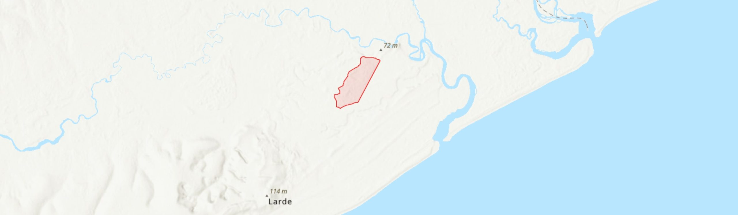
Central co-ordinates: 16.4984 S, 39.67120 E
Area: 3.24km²
Qualifying IPA Criteria
A(i)Site contains one or more globally threatened species, C(iii)Site contains nationally threatened or restricted habitat or vegetation types, AND/OR habitats that have severely declined in extent nationally
IPA assessment rationale
The Mulimone Forest qualifies as an Important Plant Area under criterion A(i) in view of its important populations of Icuria dunensis (EN), Brachystegia oblonga (CR) and Scorodophloeus torrei (EN). This site also qualifies under criterion C(iii) as the Icuria coastal dry forest is a nationally threatened and range-restricted habitat, and the Mulimone IPA is estimated to contain approximately 10% of the total area of remaining Icuria forest and is one of the best five sites globally.
Site description
Mulimone Forest is situated in coastal Larde District of Nampula Province, approximately 55 km ENE of the town of Moma and 40 km SW of the town of Angoche. This small site of 3.24 km2 is situated immediately adjacent to the Namalope heavy mineral sand operation of the Moma Titanium Minerals Mine owned by Kenmare Resources plc, one of the world’s largest titanium mines. The IPA encompasses a patch of coastal dry forest of the proposed Rovuma Centre of Plant Endemism (Burrows & Timberlake 2011; Darbyshire et al. 2019a). It was identified as of biodiversity importance during the Environmental Impact Assessment ahead of commercial exploitation of the Namalope deposit, and has subsequently been protected from development by Kenmare.
Botanical significance
This site contains a globally important stand of Icuria-dominated coastal dry forest. Icuria dunensis (‘icuri’ or ‘ncuri’) is a leguminous tree endemic to Mozambique which forms mono-dominant or co-dominant stands in small and isolated patches along a ca. 360 km stretch of the Mozambique coastline and is assessed as globally Endangered (Darbyshire et al. 2019b). The area of Icuria-dominated forest at Mulimone is approximately 2.38 km2. It is one of only five sites identified globally as being of high importance for Icuria forest. A recent vegetation survey of this site (J. Timóteo, unpubl. data) has also revealed the presence of two further globally threatened tree species endemic to Mozambique: Brachystegia oblonga (EN) and Scorodophloeus torrei (EN) both of which are locally frequent here. This site is of high importance for both these species given that most of the few other known sites are highly threatened. Brachystegia oblonga, in particular, is otherwise known only from highly disturbed woodland and dry forest remnants at Moma and at Gobene near Bajone, where it is severely threatened (Alves et al. 2014).
The understorey of the Icuria forest has previously been reported to support a population of Warneckea sessilicarpa (Alves & Sousa 2007), but the recent surveys have not found that species here (C. de Sousa & J. Timóteo, pers. obs. 2021) and so that record requires confirmation before being included in the IPA assessment. This species is noted to be locally common in Icuria stands at nearby Pilivili (A. Massingue, pers. comm. 2021).
Habitat and geology
In the areas of closed forest, Icuria dunensis forms dominant stands, with Haplocoelum foliolosum subsp. mombasense, Brachystegia oblonga and Scorodophloeus torrei also being frequent, and with occasional Hymenaea verrucosa amongst other species. Mature Icuria trees up to 30 m tall are recorded and substantial regeneration is observed in both Icuria and Brachystegia oblonga (Alves & Sousa 2007; J. Timóteo, unpubl. data). In areas of more open, disturbed forest, Icuria and Haplocoeleum are still present but with other species including Mimusops obtusifolia and Olax dissitiflora with Strynchnos sp. abundant (J. Timóteo, unpubl. data).
As elsewhere within its range, the Icuria forests are associated with low-lying ancient sand-dune deposits; at Mulimone the forest is on a slightly raised area of white sands. These dunes are rich in heavy minerals including high-grade ilmenite (titanium ore) (Kenmare Resources 2018). A layer of ca. 5 cm with leaf-litter covers the soil surface which improves soil humidity and decreases soil temperature allowing for forest regeneration. Immediately beyond the forest boundary, most of the vegetation has been substantially transformed, particularly to the west where the extensive mining operations are surrounded by infrastructure and settlements.
The climate at this site is highly seasonal, with ca. 90% of the rainfall occurring in December to March; the average annual precipitation is approximately 1,050 mm, but ca. 1,521 mm evapotranspiration (Kassam et al. 1981).
Conservation issues
Kenmare Resources acquired the Congolone heavy mineral sand deposit concession in the late 1980s, and began construction on the Moma Titanium Mineral Mine on the Namalope deposit in 2004, with production from 2007 until the present day. Even prior to the development of the Namalope operation, the Icuria forest patch in Mulimone was small and clearly demarcated from the surrounding vegetation. Historical satellite imagery available on Google Earth shows that the forest extent in late 1984 was approximately 2.42 km2. A portion of the northwest portion of the forest was destroyed in the early 1990s and this patch (“o buraco”) expanded through that decade, destroying approximately 0.17 km2 of forest. Some natural regeneration can now be observed in this area, although some mashambas of cassava have been established there. Since the survey of this forest during the EIA of the Namalope deposit, and the formal description of Icuria dunensis in the late 1990s (Wieringa 1999), this site has been protected by Kenmare as part of their programme of environmental and social responsibilities at the Moma Mine site. However, the forest is increasingly threatened by agricultural encroachment from local communities, with areas in the south of the forest in particular having been opened up using fire to clear the land for cassava and cowpea cultivation. Although some of the larger trees are left standing, they are often killed by the fires. This encroachment has accelerated since 2017. Other threats include pit-sawing for timber, cutting of poles and the stripping of Icuria bark for use in boat-making (C. Sousa, pers. obs. 2018). It is estimated that ca. 30% of Mulimone Forest has been lost through these activities within the recent past (J. Timóteo et al., unpubl. data). If protected against uncontrolled fires and agriculture encroachment, the forest may recover; enrichment planting in gaps may accelerate this natural regeneration process.
Approximately half of the area of this IPA falls within the extensive (>8,000 km2) Primeiras & Segundas Environmental Protection Area (APAIPS), gazetted in 2012, which extends along the coast south to Pebane and north to Angoche. The Icuria forests of the area between Moma and Angoche were highlighted as of high importance in the preliminary assessment of the coastal vegetation within the proposed reserve (Alves & Sousa 2007), but the northern part of the Mulimone Forest falls outside of the boundary. This whole area has also recently been recognised as a Key Biodiversity Area (WCS et al. 2021).
Ecosystem services
The Icuria forest helps to stabilise and protect the coastal sand deposits and so prevent excessive erosion during extreme weather events. It also provides important habitat and supporting services in an area that is otherwise heavily transformed. The Icuria trees providing a provisioning service for local communities, providing bark and wood, which could be managed sustainably.
Site assessor(s)
Iain Darbyshire, Royal Botanic Gardens, Kew
Camila de Sousa, Instituto de Investigação Agrária de Moçambique
Tereza Alves, Instituto de Investigação Agrária de Moçambique
Jaime Rofasse Timóteo, Eduardo Mondlane University
Clayton Langa, Agricultural Research Institute of Mozambique (IIAM)
IPA criterion A species
| Species | Qualifying sub-criterion | ≥ 1% of global population | ≥ 5% of national population | 1 of 5 best sites nationally | Entire global population | Socio-economically important | Abundance at site |
|---|---|---|---|---|---|---|---|
| Icuria dunensis Wieringa | A(i) |  |
|
|
 |
|
Abundant |
| Brachystegia oblonga Sim | A(i) | |
|
|
|
|
Frequent |
| Scorodophloeus torrei Lock | A(i) | |
|
|
|
|
Frequent |
Icuria dunensis Wieringa
Qualifying sub-criterion:
A(i)
≥ 1% of global population:
≥ 5% of national population:
1 of 5 best sites nationally:
Entire global population:
Socio-economically important:
Abundance at site:
Abundant
Brachystegia oblonga Sim
Qualifying sub-criterion:
A(i)
≥ 1% of global population:
≥ 5% of national population:
1 of 5 best sites nationally:
Entire global population:
Socio-economically important:
Abundance at site:
Frequent
Scorodophloeus torrei Lock
Qualifying sub-criterion:
A(i)
≥ 1% of global population:
≥ 5% of national population:
1 of 5 best sites nationally:
Entire global population:
Socio-economically important:
Abundance at site:
Frequent
IPA criterion C qualifying habitats
| Habitat | Qualifying sub-criterion | ≥ 5% of national resource | ≥ 10% of national resource | 1 of 5 best sites nationally | Areal coverage at site |
|---|---|---|---|---|---|
| Rovuma Icuria Coastal Dry Forest | C(iii) | |
|
|
2.38 |
Rovuma Icuria Coastal Dry Forest
Qualifying sub-criterion:
C(iii)
≥ 5% of national resource:
≥ 10% of national resource:
Areal coverage at site:
2.38
General site habitats
| General site habitat | Percent coverage | Importance |
|---|---|---|
| Forest - Subtropical/Tropical Dry Forest | 70 | Major |
| Marine Coastal/Supratidal - Coastal Sand Dunes | |
Minor |
| Artificial - Terrestrial - Arable Land | |
Minor |
| Artificial - Terrestrial - Subtropical/Tropical Heavily Degraded Former Forest | |
Minor |
Forest - Subtropical/Tropical Dry Forest
Percent coverage:
70
Importance:
Major
Marine Coastal/Supratidal - Coastal Sand Dunes
Percent coverage:
Importance:
Minor
Artificial - Terrestrial - Arable Land
Percent coverage:
Importance:
Minor
Artificial - Terrestrial - Subtropical/Tropical Heavily Degraded Former Forest
Percent coverage:
Importance:
Minor
Land use types
| Land use type | Percent coverage | Importance |
|---|---|---|
| Nature conservation | |
Major |
| Harvesting of wild resources | |
Minor |
| Agriculture (arable) | |
Minor |
Nature conservation
Percent coverage:
Importance:
Major
Harvesting of wild resources
Percent coverage:
Importance:
Minor
Agriculture (arable)
Percent coverage:
Importance:
Minor
Threats
| Threat | Severity | Timing |
|---|---|---|
| Residential & commercial development - Commercial & industrial areas | High | Ongoing - stable |
| Residential & commercial development - Housing & urban areas | Medium | Ongoing - stable |
| Energy production & mining - Mining & quarrying | High | Ongoing - stable |
| Biological resource use - Gathering terrestrial plants | Medium | Ongoing - increasing |
| Agriculture & aquaculture - Annual & perennial non-timber crops - Small-holder farming | High | Ongoing - increasing |
Residential & commercial development - Commercial & industrial areas
Severity:
High
Timing:
Ongoing - stable
Residential & commercial development - Housing & urban areas
Severity:
Medium
Timing:
Ongoing - stable
Energy production & mining - Mining & quarrying
Severity:
High
Timing:
Ongoing - stable
Biological resource use - Gathering terrestrial plants
Severity:
Medium
Timing:
Ongoing - increasing
Agriculture & aquaculture - Annual & perennial non-timber crops - Small-holder farming
Severity:
High
Timing:
Ongoing - increasing
Protected areas
| Protected area name | Protected area type | Relationship with IPA | Areal overlap |
|---|---|---|---|
| Primeiras & Segundas Environmental Protection Area (APAIPS) | Environmental Protection Area | protected/conservation area overlaps with IPA | |
Primeiras & Segundas Environmental Protection Area (APAIPS)
Protected area type:
Environmental Protection Area
Relationship with IPA:
protected/conservation area overlaps with IPA
Areal overlap:
Conservation designation
| Designation name | Protected area | Relationship with IPA | Areal overlap |
|---|---|---|---|
| Primeiras & Segundas Environmental Protection Area (APAIPS) | Key Biodiversity Area | protected/conservation area overlaps with IPA | |
| Primeiras & Segundas Environmental Protection Area (APAIPS) | Important Bird Area | protected/conservation area overlaps with IPA | |
Primeiras & Segundas Environmental Protection Area (APAIPS)
Protected area:
Key Biodiversity Area
Relationship with IPA:
protected/conservation area overlaps with IPA
Areal overlap:
Primeiras & Segundas Environmental Protection Area (APAIPS)
Protected area:
Important Bird Area
Relationship with IPA:
protected/conservation area overlaps with IPA
Areal overlap:
Management type
| Management type | Description | Year started | Year finished |
|---|---|---|---|
| Site management plan in place | Kenmare Resources plc, management plan and environmental policy for Moma Titanium Mineral Mine | |
|
Site management plan in place
Kenmare Resources plc, management plan and environmental policy for Moma Titanium Mineral Mine
Year started:
Year finished:
Bibliography
Icuria dunensis. The IUCN Red List of Threatened Species 2019: e.T136532836A136538183.
The IUCN Red List of Threatened Species Available online
The endemic plants of Mozambique: diversity and conservation status
PhytoKeys, Vol 136, page(s) 45-96 Available online
Mozambique’s centres of endemism, with special reference to the Rovuma Centre of Endemism of NE Mozambique and SE Tanzania.
South African Journal of Botany, Vol 77, page(s) 518
Preliminary assessment of the coastal vegetation and mangrove forests of the proposed conservation area of the Primeiras (1as) and Segundas (2as) Island Archipelago.
Kenmare Resources plc Annual Report and Accounts 2018.
Monopetalanthus exit. A systematic study of Aphanocalyx, Bikinia, Icuria, Michelsonia and Tetraberlinia (Leguminosae, Caesalpinioideae).
Wageningen Agricultural University Papers, Vol 99(4), page(s) 1-320
Brachystegia oblonga. The IUCN Red List of Threatened Species 2014: e.T62494198A62494201.
Assessment of land resources for rainfed crops production in Mozambique. Climate data bank and length of growing period analysis. Project Moz/75/011.


Recommended citation
Iain Darbyshire, Camila de Sousa, Tereza Alves, Jaime Rofasse Timóteo, Clayton Langa (2024) Tropical Important Plant Areas Explorer: Mulimone Forest (Mozambique). https://tipas.kew.org/site/mulimone-forest/ (Accessed on 27/07/2024)