Country: Cameroon
Administrative region: North (Region)
Central co-ordinates: 9.41450 N, 13.45280 E
Area: 53km²
Qualifying IPA Criteria
A(i)Site contains one or more globally threatened species
IPA assessment rationale
As the site of the most significant recorded global population of Polycarpaea garuensis (EN), Mount Tinguelin qualifies as an IPA under criterion A(i). Verification of the site's current condition and presence of other threatened species is urgently required.
Site description
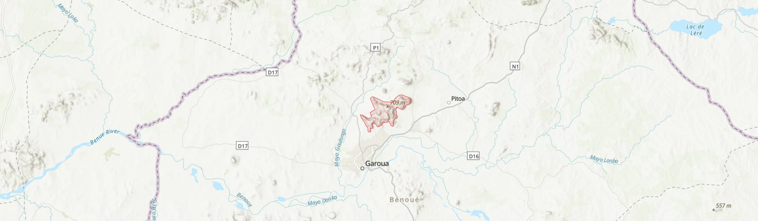
Mount Tinguelin is a sandstone tabletop formation about 10 km north of the city of Garoua in North Region, Cameroon. Garoua is an important port on the river Benue with a population exceeding 360,000 (UNDP, 2018). The proposed IPA boundary has been drawn to incorporate the main plateau area, extending from the summit peak in the east to the western rim which may be one of the locations indicated by Lebrun (1977).
Botanical significance
Polycarpaea garuensis is globally threatened (EN) and was considered a "remarkable" instance of local endemicity to the sandstone outcrops around Garoua (Lebrun, 1977). It has been collected at least three times from Mt Tinguelin (Letouzey, R. 6651; Raynal, J & A 12414; Malzy, P. 98), most recently in 1964, while two collections, including the type, collected in 1939 by Jacques-Felix, were also from sandstone rocks near Garoua and may be from the same site. Other collections exist from around Garoua and most recently from nearby Sanguere in 1983 (Abba, 572), while a single further record exists from Nigeria which is considered possibly anomalous by Onana & Cheek (2011). Vepris heterophylla (EN) was recorded in 1964 and although there are several collections in West Africa, there are few other sites in Cameroon.
Other threatened species collected in the vicinity include Khaya senegalensis (VU), Afzelia african (VU), Cleome coeruleorosea (VU), Cyphostemma cuneatum (EN), Barleria bornuensis (VU), Chlorophytum caudatibracteatum (DD) and Chlorophytum altum (EN). It is not known if any of these are present at the Tinguelin site. Plagiosiphon longitubus (CR) has also been recorded nearby but this species is more widespread than first though and now considered not threatened (Onana & Cheek, 2011).
Habitat and geology
The climate is hot with a single wet season (Koppen classfication: Aw) and c. 1000 mm of rain p.a., peaking in August. The winter is dry with no rain typically recorded between December and February. Daily maximum average temperatures range from 30.6 °C in August to nearly 40 °C in March and April, while daily minima drop to 17.5 °C in December (WMO, 2022; data covers period 1971-2000).
Garoua is situated in a sedimentary basin, associated with the large Benue basin running through Nigeria from Lake Chad to the Gulf of Guinea (Cratchley et al., 1984). The depression at Garoua is infilled with middle to upper Cretaceous marine sandstone overlying the crystalline basement rocks (Kamguia et al., 2005). The sandstone is medium to course grained, dominated by quartz with abundant kaolinite minerals (Bessong et al. 2011) and forms impressive plateau formations at the site overlooking the plain to the southwest. At the eastern foot of the hill, feldspar deposits have also been reported (Mbodiam, 2016). Soils, deriving from the sandstone rocks, are described as sandy with bare rock outcrops (Lebrun, 1977). One of the collections of Polycarpaea garuensis was described as from the "summit of the western sandstone cliff in the joints of the bare horizontal slabs of the edge of the plateau, between patches of Loudetia grassland".
Mt Tinguelin is within the East Sudanian savanna ecoregion according to the Olson et al. (2001) classification. On Letouzey's (1985) detailed phytogeographic maps it is type 55: "Sudano-Sahelian wooded savannas around the Benoué, ± degraded to Burkea africana; sometimes fallow".
Conservation issues
The site is in need of surveying to re-locate Polycarpaea garuensis, to discover how much of the proposed site it occupies and what threats it faces, and to investigate the other flora. Other important species found close to the site may have been more heavily impacted by development and land-use change.
Garoua is one of the largest cities in Cameroon, having grown rapidly in size to an estimated 361,000 inhabitants in 2022, a tenfold increase in 50 years (UNDP, 2018). Natural vegetation in this region is very heavily impacted by agricultural production, fuelwood collection and grazing, associated with high population densities (KBA partnership, 2022). The rocky sandstone slabs apparently favoured by Polycarpaea garuensis are unlikely to be used for cultivation of local crops such as cotton but could be degraded by grazing and fire.
Feldspar deposits at the foot of the site may pose an additional local threat (Mbodiam, 2016). Invasive species are also probably a greater concern in these grazed savanna regions than in the wet forests of southern Cameroon.
The Gashiga-Demsa IBA and KBA (KBA Partnership, 2022) is demarcated a few km to the west of the site and was considered the only non-protected wooded site remaining in North region but already under threat in 2000; it is not know how much survives.
Ecosystem services
The sandstone plateau formations are striking and command views of the landscape and town. Therefore they are a potential tourist and leisure attraction.
Site assessor(s)
Bruce Murphy, Royal Botanic Gardens, Kew
IPA criterion A species
| Species | Qualifying sub-criterion | ≥ 1% of global population | ≥ 5% of national population | 1 of 5 best sites nationally | Entire global population | Socio-economically important | Abundance at site |
|---|---|---|---|---|---|---|---|
| Polycarpaea garuensis J.-P.Lebrun | A(i) |  |
|
|
 |
|
|
| Vitellaria paradoxa C.F.Gaertn. | A(i) | |
|
|
|
|
|
| Vepris heterophylla (Engl.) Letouzey | A(i) | |
|
|
|
|
Polycarpaea garuensis J.-P.Lebrun
Qualifying sub-criterion:
A(i)
≥ 1% of global population:
≥ 5% of national population:
1 of 5 best sites nationally:
Entire global population:
Socio-economically important:
Abundance at site:
Vitellaria paradoxa C.F.Gaertn.
Qualifying sub-criterion:
A(i)
≥ 1% of global population:
≥ 5% of national population:
1 of 5 best sites nationally:
Entire global population:
Socio-economically important:
Abundance at site:
Vepris heterophylla (Engl.) Letouzey
Qualifying sub-criterion:
A(i)
≥ 1% of global population:
≥ 5% of national population:
1 of 5 best sites nationally:
Entire global population:
Socio-economically important:
Abundance at site:
General site habitats
| General site habitat | Percent coverage | Importance |
|---|---|---|
| Savanna - Dry Savanna | |
|
| Rocky Areas - Rocky Areas [e.g. inland cliffs, mountain peaks] | |
Savanna - Dry Savanna
Percent coverage:
Importance:
Rocky Areas - Rocky Areas [e.g. inland cliffs, mountain peaks]
Percent coverage:
Importance:
Threats
| Threat | Severity | Timing |
|---|---|---|
| Residential & commercial development - Housing & urban areas | Medium | Ongoing - trend unknown |
| Agriculture & aquaculture - Annual & perennial non-timber crops - Small-holder farming | Medium | Ongoing - trend unknown |
| Agriculture & aquaculture - Livestock farming & ranching - Small-holder grazing, ranching or farming | Medium | Ongoing - trend unknown |
| Natural system modifications - Fire & fire suppression - Increase in fire frequency/intensity | Medium | Ongoing - trend unknown |
| Energy production & mining - Mining & quarrying | Low | Future - inferred threat |
Residential & commercial development - Housing & urban areas
Severity:
Medium
Timing:
Ongoing - trend unknown
Agriculture & aquaculture - Annual & perennial non-timber crops - Small-holder farming
Severity:
Medium
Timing:
Ongoing - trend unknown
Agriculture & aquaculture - Livestock farming & ranching - Small-holder grazing, ranching or farming
Severity:
Medium
Timing:
Ongoing - trend unknown
Natural system modifications - Fire & fire suppression - Increase in fire frequency/intensity
Severity:
Medium
Timing:
Ongoing - trend unknown
Energy production & mining - Mining & quarrying
Severity:
Low
Timing:
Future - inferred threat
Bibliography
Red Data Book of the flowering plants of Cameroon
Notice de la carte phytogéographique du Cameroun au 1: 500,000.
Terrestrial ecoregions of the world: a new map of life on earth
Bioscience, Vol 51, page(s) 3-938
World Urbanization Prospects: The 2018 Revision, Online Edition
Un Polycarpaea nouveau du Cameroon
Adansonia sér. 2, Vol 16(4), page(s) 461-464
World Weather Information Service: Garoua, Cameroon
Feldspar deposit discovered at foot of Mount Tinguelin, in region of North Cameroon
Busines in Cameroon. Friday 24 June, 2016 Available online
Geophysical and geological evidence for the Benue-Chad Basin Cretaceous rift valley system and its tectonic implications
Journal of African Earth Sciences, Vol 2(2), page(s) 141-150
Geological models deduced from gravity data in the Garoua basin, Cameroon
Journal of Geophysics and Engineering, Vol 47–152
Diagenesis in Cretaceous Formations of Benue Trough in the Northern Part of Cameroon: Garoua Sandstones
World J of Engineering and Pure and Applied Sci., Vol 1(3), page(s) 58


Recommended citation
Bruce Murphy (2024) Tropical Important Plant Areas Explorer: Mount Tinguelin (Cameroon). https://tipas.kew.org/site/mount-tinguelin/ (Accessed on 27/07/2024)