Country: Mozambique
Administrative region: Zambézia (Province)
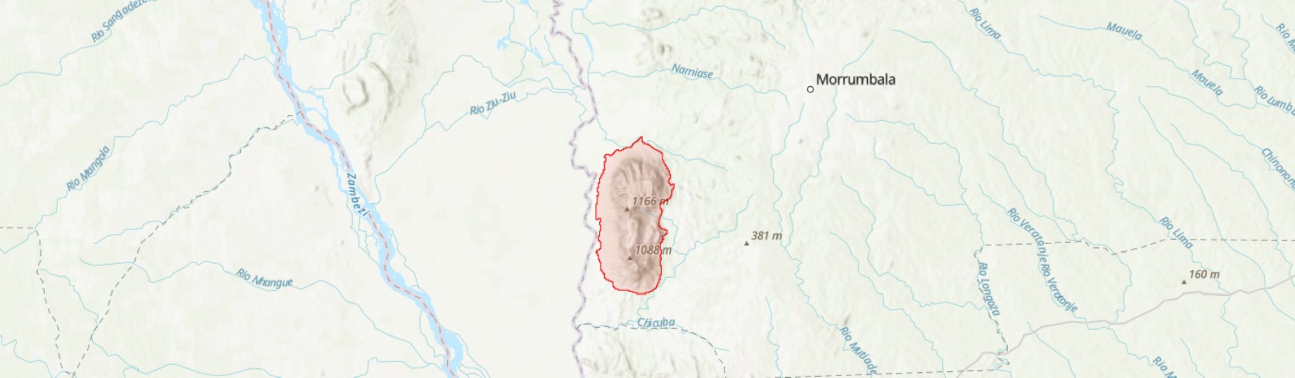
Central co-ordinates: 17.48 S, 35.38500 E
Area: 135km²
Qualifying IPA Criteria
A(i)Site contains one or more globally threatened species, C(iii)Site contains nationally threatened or restricted habitat or vegetation types, AND/OR habitats that have severely declined in extent nationally
IPA assessment rationale
Mount Morrumbala qualifies an Important Plant Area under subcriterion A(i), with two threatened species meeting this threshold. The site hosts the only known population of Critically Endangered species Crassula morrumbalensis. Urgent conservation research and planning is required to protect this species from extinction. In addition, one Vulnerable taxon, Celosia pandurata also triggers A(i) of the IPA criteria and it is highly likely more threatened species will be documented from this site.
Mount Morrumbala also qualifies under C(iii) as it is one of the top five sites nationally for low altitude moist forest. Although another threatened and restricted habitat type, mid montane moist forest, is also present within this IPA, there is only a very limited area of this habitat and so it is unlikely to trigger C(iii).
Site description
Mount Morrumbala, known sometimes as Mount Tembe, is an IPA in Morrumbala District of Zambézia Province, adjacent to its border with Tete Province and 30 km south of the Mozambique-Malawi border. The IPA covers an area of 135 km2 with the Shire River running to the west and the Nambuur River to the north of this site. Morrumbala town, the district centre, is a short distance away from the IPA, 20 km to the north-east, and there are a number of communities that live along the Shire River. Tembe-Tembe is the closest village and, while it mostly falls outside this IPA, a small number of homesteads on the lower slopes are inside the site boundary.
Little botanical research has taken place in recent decades on Mount Morrumbala, but from previous botanical collections, it is clear that there are plant species of conservation interest at this site.
Botanical significance
Mount Morrumbala is the only known locality for Critically Endangered species Crassula morrumbalensis. This species is known from a single collection made in 1942 by A.R. Torre. Although there is little known about C. morrumbalensis, suitable habitat is described as “moist savanna”, presumably the escarpment miombo that dominates the eastern slopes. This habitat is currently experiencing continued degradation through the opening of machambas (Google Earth 2020; World Resources Institute 2021) and so urgent research is required to confirm the continued presence of this species and establish the impact of this habitat loss on its population size.
One additional threatened species has been recorded within this IPA. Vulnerable species Celosia pandurata is endemic to central Mozambique, occurring in lowland forests of Mount Morrumbala, and is threatened at multiple locations by the expansion of agriculture (Richards 2021). There is also a doubtful record of Coffea zanguebariae (VU), collected in a steep gully on the western side of the mountain (GBIF.org 2021). The voucher states that this specimen is a multi-stemmed 12 m tall tree with “pale, longitudinally scaly bark”, while in contrast C. zanguebariae is usually up to 6 m and tends to have smooth bark (A. Davis, pers. comm. 2021). This specimen could potentially be C. salvatrix (EN), which occurs in similar moist montane forests, including Mount Chiperone [MOZTIPA035], another mountain of western Zambézia Province. C. salvatrix is known to have buff coloured, cracked bark similar to the specimen description, although, like C. zanguebariae, is also a bush or small tree (Bridson & Verdcourt et al. 2003). Further collections of Coffea on Morrumbala are required to identify the taxon as there is a strong possibility it may be threatened species.
In addition to these threatened species, there are two Near Threatened species, Searsia (formerly Rhus) acuminatissima and Cola mossambicensis, that have been recorded from this IPA. Although not endemic, the ranges of both these species fall predominantly within Mozambique.
Overall, there are four Mozambican endemics known from this IPA, including the two threatened species C. morrumbalensis and Celosia pandurata alongside Bothriocline moramballae (LC) and Pavetta gardeniifolia var. appendiculata. Mount Morrumbala is the southernmost location for these latter two taxa, both of which are known from fewer than five locations globally.
There has been limited botanical collecting done within this IPA in recent decades, with many of the collections made in the 1940s (F.A. Mendonça and A.R. Torre) and in the 1970s (T. Müller and G. Pope). Further botanical surveying is needed to fully characterise the habitats and to establish the continued presence and population sizes of threatened species such as Crassula morrumbalensis. Further investigation could also reveal additional threatened or rare species.
There are two nationally threatened and restricted habitat types present at this IPA, low altitude moist forest and medium altitude moist forest. It is unlikely that there is enough medium altitude forest to trigger C(iii) as Morrumbala only reaches a peak of 1,172 m and so this habitat type is limited to a small area below the peak ridge. There is a much larger area of low altitude moist forest within this IPA, likely between 10 – 15 km2. Overall, Morrumbala is one of five best sites for low altitude forest nationally and so triggers sub-criterion C(iii) of the IPA criteria, although further research is required to accurately delineate and measure this fragmented habitat at this site. To the north of this IPA, on the other side of Cundo-cundo stream, there is additional intact, lowland forest. This nearby area is currently understudied; however, it could be included in the IPA if found to be botanically interesting.
Habitat and geology
Mount Morrumbala is the result of multiple, predominantly syenite, intrusions in the surrounding plain (Coelho 1959; Araújo et al. 1973). The mountain reaches a peak of 1,172 m and is 15 km across from north to south and 5 km from east to west. Soils have not been fully categorised, but the lower slopes are known to have thin, rocky soils (Andrada #1570) while the soils towards the west of the IPA, by the Shire River, are clayey (Dungo #185). It is likely that the soils in gullies are deep and with greater fertility and moisture that elsewhere in this IPA.
The site experiences a winter dry season, between April and October, with temperatures recorded at nearby Morrumbala town ranging from an average low of 17.2°C and a high of 29.8°C in summer (Ministério da Administração Estatal 2005). Average monthly precipitation in the district is 1,017 mm, however, given then topology of this IPA, there is likely a stark difference in precipitation and temperature compared to the surrounding plain, with the mountain experiencing lower temperatures and higher precipitation - some of which likely occurs through frequent mists.
According to analysis by Lötter et al. (2021), the northern and western lowlands of Mount Morrumabala can be classified as “Central Lowland Moist Forest”. Although the species composition at this site is yet to be documented, some of the collections made in this area include species typical of this vegetation type (GBIF.org 2021). Canopy trees include Albizia adianthifolia, Bersama abyssinica, Newtonia buchananii, Macaranga capensis and Terminalia (formerly Pteleopsis) myrtifolia, while trees and shrubs in the understorey include Cola greenwayi and Vangueria esculenta alongside the herbaceous Celosia pandurata (VU). Lianas and climbers such as Landolphia buchananii, Gouania longispicata and Tiliacora funifera have also been recorded in these forests. At higher altitudes on the northern and western slopes, Lötter et al. (2021) delineate a small strip of Central Mid-elevation Moist Forest vegetation below the peak ridge. It is unclear how these forests may differ from the lowland forests at this site, however, in these forests Newtonia buchananii may be more dominant, as is the case in other moist mid-elevation forests.
On the eastward slopes of the mountain, the vegetation is largely moist miombo, similar to that found on the southern escarpments of Mount Gorongosa (Lötter et al. 2021). Little is known of this vegetation on Mount Morrumbala. One collection describes woodland on the mountain as dominated by Brachystegia tamarindoides subsp. microphylla (Muller & Pope #1973), a species typical of areas with thin soils over which also dominates the escarpment miombo of Mount Gorongosa. While this collection was made on the western slopes of the mountain, it is highly likely that the eastern miombo is also dominated by B. tamarindoides subsp. microphylla and that this vegetation type also occurs in a mosaic within the forests on the western slopes. The understorey of this woodland has not been documented; however, it is known to host the only known population of Critically Endangered species Crassula morrumbalensis, a perennial, succulent herb. As Crassula species are often associated with rocky areas, it is highly likely that this species occurs in areas of rocky miombo at this site.
There are a number of riverine forests in deep gorges on the mountain and it is very possible that the Vulnerable species Khaya anthotheca occurs in these areas as is the case in several other montane gallery forests. The herbaceous species Impatiens oreocallis was collected by a waterfall on the mountain, growing within the spray zone. A species native to Malawi, Mozambique and Tanzania, this is likely one of the southernmost collections of I. oreocallis.
Summit vegetation has not yet been described. Decorsea schlechteri is known to be associated with rocky outcrops on the mountain although this species likely occurs on the slopes below the summit.
Conservation issues
Mount Morrumbala does not fall within a protected area, Key Biodiversity Area or Important Bird Area. However, with the presence of the entire global population of Critically Endangered species Crassula morrumbalensis, the site would qualify as an Alliance of Zero Extinction site and KBA under sub-criterion A1e.
Many of the slopes of this site are theoretically protected by the Environment Act (Lei . 20/97 of 1997) which prohibits cultivation of annual crops on slopes greater than 7° and perennial crops on slopes greater than 14° (Timberlake et al. 2007). However, in practice this law appears to have little impact on preventing cultivation on this mountain, with a continued increase in agricultural expansion on Morrumbala. Agricultural expansion particularly impacts the miombo on the eastern slopes and the lowland forest on the western slopes, this is likely due to the flatter terrain in these places. Both the forest and miombo in these accessible areas are heavily fragmented, with the rate of tree cover loss in this IPA accelerating since 2001 (World Resources Institute 2021). Only the less accessible areas, including forests on steep slopes and in gullies, remain completely intact.
This loss of key habitats will inevitably be a major threat to the rare and range limited species that occur on Mount Morrumbala. Urgent research and conservation action is needed to protect these habitats and the species that reside within. One reason for the increased pressure on land within this IPA may be land disputes elsewhere, which are particularly pronounced in the Shire River valley and around nearby Morrumbala town (Ministério da Administração Estatal 2005). Work with local communities to solve these issues could go a long way towards minimising agricultural expansion onto Morrumbala. The land within Morrumbala District is otherwise highly favourable and the most productive across Zambézia Province. There is evidence that solving land disputes could be an effective strategy and this is one of the key actions implemented by the conservation and development project, Legado: Namuli, on Mount Namuli led by Legado and Nitidae (Nitidæ 2021). This project has helped secure land rights for local people as a key action towards protecting valuable montane habitats from agriculture expansion. Applying this approach to Mount Morrumbala could similarly relieve pressures on the montane habitats of this site.
Slowing the rate of agricultural expansion on Mount Morrumbala, alongside restoration of habitats, may also be of great importance to local communities as the loss of woodland and forest, particularly at higher altitudes, may increase the risk of landslides. Loss of substrate stabilising forest on Serra Tumbine, a mountain 150 km to the north-east of this IPA with a similar syenite geology, led to a catastrophic landslide following heavy rains in 1998 (see MOZTIPA036). The World Bank categorise the rainfall-triggered landslide hazard as “very high” within this IPA (World Bank 2019). Further research is urgently required to understand if maintenance of complex forest and woodland ecosystems on this mountain could help mitigate the risk of landslide.
Given the number of threats, including catastrophic events such as landslides, ex situ conservation should be considered for Crassula morrumbalensis alongside in situ actions. C. morrumbalensis is predicted to have orthodox seed storage behaviour (Wyse & Dickie 2018) and so collection of seeds for seed banking is highly recommended.
Much like the plant taxa of this site, the animal taxa of Morrumbala are yet to be inventoried. Inventory work for avian taxa has been described as urgent by Spottiswoode et al. (2008) due to the presence of evergreen forest, known to provide habitat for rare and threatened birds elsewhere in Mozambique.
Ecosystem services
There are a number of streams originating on Mount Morrumbala which are tributaries of the Shire River. Agriculture in the Shire River valley has been commercially important, including sugar and cotton plantations (Inguaggiato et al. 2002), and continues to be important to livelihoods. However, agriculture should be undertaken sustainably to prevent disturbance of montane habitats which could, in turn, increase evapotranspiration and decrease water availability and increase erosion risk.
The forests and woodlands on this mountain are likely valued locally for timber and fuel - wood is the primary source of fuel for cooking in Morrumbala District (Ministério da Administração Estatal 2005).
This IPA may also host important gene resources due to the potential presence of a Coffea crop wild relative which could support the breeding of commercial coffee species. This species may also have commercial value as a beverage itself.
Site assessor(s)
Sophie Richards, Royal Botanic Gardens, Kew
Iain Darbyshire, Royal Botanic Gardens, Kew
IPA criterion A species
| Species | Qualifying sub-criterion | ≥ 1% of global population | ≥ 5% of national population | 1 of 5 best sites nationally | Entire global population | Socio-economically important | Abundance at site |
|---|---|---|---|---|---|---|---|
| Crassula morrumbalensis R.Fern. | A(i) |  |
|
|
|
 |
Unknown |
| Celosia pandurata Baker | A(i) | |
|
|
|
|
Unknown |
Crassula morrumbalensis R.Fern.
Qualifying sub-criterion:
A(i)
≥ 1% of global population:
≥ 5% of national population:
1 of 5 best sites nationally:
Entire global population:
Socio-economically important:
Abundance at site:
Unknown
Celosia pandurata Baker
Qualifying sub-criterion:
A(i)
≥ 1% of global population:
≥ 5% of national population:
1 of 5 best sites nationally:
Entire global population:
Socio-economically important:
Abundance at site:
Unknown
IPA criterion C qualifying habitats
| Habitat | Qualifying sub-criterion | ≥ 5% of national resource | ≥ 10% of national resource | 1 of 5 best sites nationally | Areal coverage at site |
|---|---|---|---|---|---|
| Low Altitude Moist Forest 100-600 m | C(iii) | |
|
|
10 |
| Medium Altitude Moist Forest 900-1400 m | C(iii) | |
|
|
2 |
Low Altitude Moist Forest 100-600 m
Qualifying sub-criterion:
C(iii)
≥ 5% of national resource:
≥ 10% of national resource:
Areal coverage at site:
10
Medium Altitude Moist Forest 900-1400 m
Qualifying sub-criterion:
C(iii)
≥ 5% of national resource:
≥ 10% of national resource:
Areal coverage at site:
2
General site habitats
| General site habitat | Percent coverage | Importance |
|---|---|---|
| Forest - Subtropical/Tropical Moist Lowland Forest | |
Major |
| Forest - Subtropical/Tropical Moist Montane Forest | |
Minor |
| Savanna - Moist Savanna | |
Major |
| Rocky Areas - Rocky Areas [e.g. inland cliffs, mountain peaks] | |
Minor |
| Artificial - Terrestrial - Arable Land | |
Major |
Forest - Subtropical/Tropical Moist Lowland Forest
Percent coverage:
Importance:
Major
Forest - Subtropical/Tropical Moist Montane Forest
Percent coverage:
Importance:
Minor
Savanna - Moist Savanna
Percent coverage:
Importance:
Major
Rocky Areas - Rocky Areas [e.g. inland cliffs, mountain peaks]
Percent coverage:
Importance:
Minor
Artificial - Terrestrial - Arable Land
Percent coverage:
Importance:
Major
Land use types
| Land use type | Percent coverage | Importance |
|---|---|---|
| Agriculture (arable) | |
Major |
| Harvesting of wild resources | |
Unknown |
Agriculture (arable)
Percent coverage:
Importance:
Major
Harvesting of wild resources
Percent coverage:
Importance:
Unknown
Threats
| Threat | Severity | Timing |
|---|---|---|
| Agriculture & aquaculture - Annual & perennial non-timber crops - Small-holder farming | High | Ongoing - increasing |
| Residential & commercial development - Housing & urban areas | Low | Ongoing - trend unknown |
| Natural system modifications - Fire & fire suppression - Increase in fire frequency/intensity | Unknown | Ongoing - trend unknown |
| Biological resource use - Logging & wood harvesting | Unknown | Ongoing - trend unknown |
| Geological events - Avalanches/landslides | High | Future - inferred threat |
Agriculture & aquaculture - Annual & perennial non-timber crops - Small-holder farming
Severity:
High
Timing:
Ongoing - increasing
Residential & commercial development - Housing & urban areas
Severity:
Low
Timing:
Ongoing - trend unknown
Natural system modifications - Fire & fire suppression - Increase in fire frequency/intensity
Severity:
Unknown
Timing:
Ongoing - trend unknown
Biological resource use - Logging & wood harvesting
Severity:
Unknown
Timing:
Ongoing - trend unknown
Geological events - Avalanches/landslides
Severity:
High
Timing:
Future - inferred threat
Management type
| Management type | Description | Year started | Year finished |
|---|---|---|---|
| No management plan in place | |
|
No management plan in place
Year started:
Year finished:
Bibliography
Google Earth Satellite Imagery
Threatened Bird Species on Two Little-Known Mountains (Chiperone and Mabu) in Northern Mozambique.
Ostrich, Vol 79, page(s) 1-7
Biodiversity and Conservation of Mount Chiperone, Mozambique
Darwin Initiative Award 15/036: Monitoring and Managing Biodiversity Loss in South-east Africa's Montane Ecosystems, page(s) 1-33 Available online
Disaster Risk Profile: Mozambique
Global Forest Watch
Flora Zambesiaca Vol. 5, Part 3: Rubiaceae
Historical Vegetation Map and Red List of Ecosystems Assessment for Mozambique – Version 1.0 – Final report
NAMULI SKY ISLAND - Creation of a new protected area around Mount Namuli – Nitidæ
Taxonomic affinity, habitat and seed mass strongly predict seed desiccation response: A boosted regression trees analysis based on 17539 species
Annals of Botany, Vol 121, page(s) 71-83 Available online
Contribuição Para o Conhecimento Da Geologia Da Área de Morrumbala-Mutarara (Folha SUL-E-36/L, Grau Quadrado 1735)
Boletim Dos Serviços de Geologia e Minas, Vol 37, page(s) 1-76
Reconhecimentos Petrográficos Sumários Dos Maciços Da Lupata, Morrumbala, Chiperone-Derre e Milange
Boletim Dos Serviços de Geologia e Minas, Vol 26, page(s) 1-47
GBIF Occurrence Download. Mount Morrumbala
Perfil Do Distrito de Morrumbala: Província Da Zambézia
The Role of Rural Producers’ Organizations within Development Processes: a Case Study on Morrumbala District
Dynamics of poverty and patterns of economic accumulation in Mozambique


Recommended citation
Sophie Richards, Iain Darbyshire (2024) Tropical Important Plant Areas Explorer: Mount Morrumbala (Mozambique). https://tipas.kew.org/site/mount-morrumbala/ (Accessed on 27/07/2024)