Country: Ethiopia
Administrative region: Southern Nations, Nationalities, and Peoples' (Regional State)
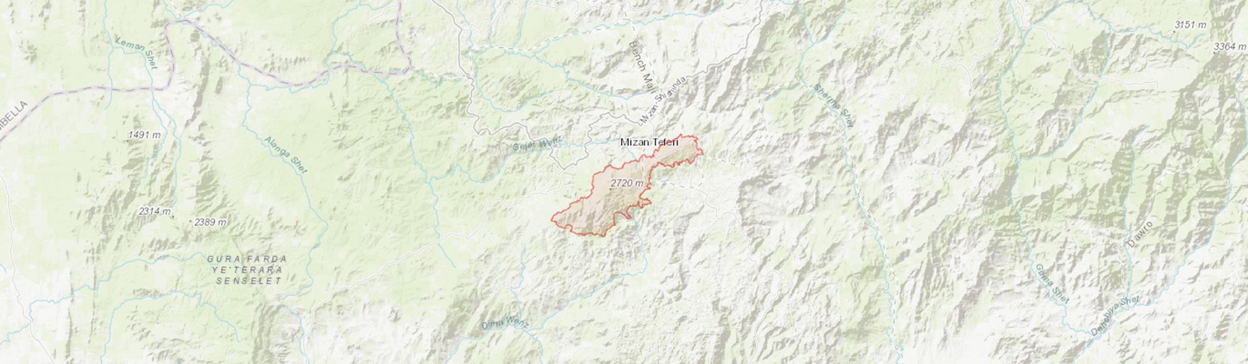
Central co-ordinates: 6.96532 N, 35.67209 E
Area: 138km²
Qualifying IPA Criteria
A(i)Site contains one or more globally threatened species
IPA assessment rationale
Mount Karkarha qualifies as an IPA under criterion A(i) due to the presence of the globally threatened, Ethiopian endemic species Dorstenia soerensenii Friis (EN) and Scadoxus nutans (VU) for which this IPA is considered to be an important site.
Site description
Mount Karkarha, also known as Kaka mountain, is located within the Southern Nations, Nationalities, and People’s Regional Sate, in the Kefa floristic region. It is not to be confused with Mount Kaka in the Oromia Regional State. Some sources refer to the IPA as Gem mountain, however this name is uncomfirmed and requires further research (Kassa et al., 2017a; Kassa et al., 2019). Elevation of the mountain ranges from 1808 m to 2685 m. The Mount Karkarha IPA is situated approximately 50 km west of the Bonga Forests IPA and approximately 17 km SE of the Shako-Bench Forest IPA. It is bordered to the north by the town of Mizan Teferi. A road that joins the B53, the main road between Mizan Teferi and Bonga, runs through the northernmost part of the IPA.
The mountain is under researched in terms of its biodiversity and there has not been a comprehensive botanical survey to date, but it is known to support intact forest with rare and threatened species present.
Botanical significance
The Mount Karkarha IPA is characterised by Moist Evergreen Afromontane Forest (MAF) (Friis et al., 2010). There has been only very limited botanical surveying of this site to date. However, the IPA appears to hold an extensive area of partially intact MAF forest and is therefore an important example of this threatened habitat.
This IPA is of botanical significance as one of the few localities of the globally threatened, Ethiopian endemic Dorstenia soerensenii Friis (EN), an understorey shrub often found along small steams and in deep shade. Records of that species are only known from Bonga, Sheka, Mount Karkarha, and near Maji. It also contains a population of a second threatened Ethiopian endemic, the attractive herb Scadoxus nutans (Friis & I.Björnstad) Friis & Nordal.
According to Kassa et al. (2018), three Ethiopian endemics are present within the northern slopes of the forest: Solanecio gigas (Vatke) C.Jeffrey, Millettia ferruginea Hochst. (LC) and Vernonia tewoldei Mesfin (LC). Three further Ethiopian endemics were identified by Kassa et al. (2018): Cirsium schimperi (Vatke) C. Jeffrey, Echinops kebericho Mesfin (NT) and Pentanema confertiflorum (A.Rich.) D.Gut.Larr. et al. However, the natural distribution of these latter species does not include the Kefa floristic region (Mesfin Tadesse, 2004) and so their presence at this site is questionable. The Ethiopian endemic Bidens pachyloma (Oliv. & Hiern) Cufod., has been recorded within agroforestry areas at the edge of the IPA (Kassa et al., 2018).
Also of note is the widespread medicinal timber species, Prunus africana (Hook.f.) Kalkman (VU), reported at low levels within the IPA (Kassa et al., 2018).
Habitat and geology
Mount Karkarha is characterised by steep terrain, dominated by Moist Evergreen Afromontane Forest (Friis et al., 2010). The northern slopes of the IPA are located within the upper Gacheb catchment which drains into the White Nile through the Baro-Akobo river system (Kassa et al., 2017a).
Botanical records from 1976 described the IPA as montane forest with Aningeria spp., Schefflera spp., and Ficus spp. dominating the upper canopy; Cyathea manniana Hook. is abundant in the lower canopy; the ground layer is dominated by terrestrial ferns such as Didymochlaena, Tectaria, Marratia, and Thelypteris (Gilbert #4203). Grewia ferruginea Hochst. ex A.Rich, Vernonia amygdalina Delile, and Solanecio mannii (Hook.f.) C.Jeffrey are also common within the lower canopy (Kassa et al., 2017b). Epiphytic ferns, such as Elaphoglossum deckenii (Kuhn) C.Chr., have been recorded within the IPA (Roux, 2011).
Kassa et al. (2018) recorded the most common tree species within edges of the northern slopes of the IPA as Juniperus procera Hochst. ex Endl., Cyathea manniana, Polyscias fulva (Hiern) Harms, Astropanax abyssinicus (Hochst. ex A.Rich.) Seem. (Schefflera abyssinica), and the introduced Grevillea robusta A.Cunn. ex R.Br. The dominant shrub species were Vernonia amygdalina, Solanecio gigas, and the introduced Delonix regia (Boijer) Raf. The ground flora is dominated by Plectranthus barbatus Andrews, Bidens pilosa L., and Veronica persica Poir..
Within the Gacheb catchment, agroforestry of Coffea arabica L. as a cash crop, and Ensete ventricosum Welw. Cheesman and Aframomum corrorima Braun as food crops is common (Kassa et al., 2019). Maize is the most common crop grown in the agricultural fields surrounding the IPA (Kassa et al., 2019). Native trees such as Albizia gummifera J.F.Gmel C.A.Sm., Cordia africana Lam., and Millettia ferruginea Hochst. Baker are used for shade, fodder, and timber (Kassa et al., 2019).
The general lithology of the area is comprised of underlying Precambrian basement rock overlain by Tertiary volcanic rocks including rhyolites (Schluter et al., 2008; Kassa et al., 2017a; Kassa et al 2017b). Soils are predominantly umbric nitisols on hill slopes and dystic leptosols on crests (Jones et al., 2013). Climate is characterised by unimodal rainfall with the rainy season running from mid-March to mid-November (Kassa et al., 2019). The annual mean rainfall for the nearby town of Mizan Teferi is approximately 1,780 mm (Kassa et al., 2019). The lower sections of the northern slopes of Mount Karkarha averaged ca. 1,313-1,566 mm across three temporary rain gauge stations between 2013 and 2014 (Kassa et al., 2019).
Conservation issues
Mount Karkarha does not fall within a protected area, biodiversity management plan, Key Biodiversity Area, or Important Bird Area (Protected Planet, 2021).
Satellite imagery from 1984 suggests that forest cover was once more extensive at ca. 18,800 ha, compared to the current ca. 13,757 ha. Forest fragmentation is evident as once connected patches of forest are now disjunct from the current IPA (Google Earth, 2021). This is supported by the findings of Kassa et al. (2017b & 2018) through local knowledge on land use changes. Areas of cropland and agroforestry surrounding the IPA were reportedly natural forest 14-23 years ago (Kassa et al., 2017b). The largest areas of forest loss over the last 30 years have occurred to the south of the IPA where the towns Fachi and Show Gimira have expanded, where areas that were once forest are now agricultural fields or settlement (Google Earth, 2021).
The presence of secondary vegetation, such as Albizia gummifera-dominated forest in the northern slopes of the IPA, could suggest historical logging followed by regrowth (Kassa et al., 2019).
Conversion of forest to other land uses is inferred to be a continuing and future threat due to the IPA being encompassed by agricultural fields and bordered by Mizan Teferi to the north and smaller towns and settlements to the east, south, and west.
Chanie & Yirsaw (2018) reported that no natural forest remains in the Mizan-Aman woreda but rather 320 ha of private forest, 19 ha of community forest, and 54 ha of government forest, it is unclear if or how this relates to the forest of Mount Karkarha.
Ecosystem services
The ecosystem services of this site are not well documented. Forested areas in the wider Bench Maji zone, within which the IPA resides, are utilised for timber, honey production, shade crops, and food (NTFP, 2004). The loss of forest cover within the IPA since the 1980s would suggest that the Mount Karkarha forest is used for fuelwood and timber. Over 98% of households in the Bench Maji zone utilise forest products (Chanie & Yirsaw, 2018).
Getachew (2010, in Kassa et al., 2017a) reported that the forest of Mount Karkarha prevents against soil erosion; higher rates of soil loss were recorded in areas where the forest had been converted into other land uses.
There is no known tourism in the area.
Site assessor(s)
Assessed by:
Eden House, Royal Botanic Gardens, Kew
Iain Darbyshire, Royal Botanic Gardens, Kew
Sebsebe Demissew, Addis Ababa University
Sileshi Nemomissa, Addis Ababa University
Ermias Lulekal, Addis Ababa University
Tesfaye Awas, Ethiopian Biodiversity Institute
Birhanu Belay Telake, Gullele Botanic Garden
IPA criterion A species
| Species | Qualifying sub-criterion | ≥ 1% of global population | ≥ 5% of national population | 1 of 5 best sites nationally | Entire global population | Socio-economically important | Abundance at site |
|---|---|---|---|---|---|---|---|
| Dorstenia soerensenii Friis | A(i) |  |
|
|
 |
|
|
| Scadoxus nutans (Friis & I.Björnstad) Friis & Nordal | A(i) | |
|
|
|
|
Dorstenia soerensenii Friis
Qualifying sub-criterion:
A(i)
≥ 1% of global population:
≥ 5% of national population:
1 of 5 best sites nationally:
Entire global population:
Socio-economically important:
Abundance at site:
Scadoxus nutans (Friis & I.Björnstad) Friis & Nordal
Qualifying sub-criterion:
A(i)
≥ 1% of global population:
≥ 5% of national population:
1 of 5 best sites nationally:
Entire global population:
Socio-economically important:
Abundance at site:
General site habitats
| General site habitat | Percent coverage | Importance |
|---|---|---|
| Forest - Subtropical/Tropical Moist Montane Forest | |
Major |
| Artificial - Terrestrial - Subtropical/Tropical Heavily Degraded Former Forest | |
Minor |
Forest - Subtropical/Tropical Moist Montane Forest
Percent coverage:
Importance:
Major
Artificial - Terrestrial - Subtropical/Tropical Heavily Degraded Former Forest
Percent coverage:
Importance:
Minor
Land use types
| Land use type | Percent coverage | Importance |
|---|---|---|
| Harvesting of wild resources | |
Unknown |
Harvesting of wild resources
Percent coverage:
Importance:
Unknown
Management type
| Management type | Description | Year started | Year finished |
|---|---|---|---|
| No management plan in place | |
|
No management plan in place
Year started:
Year finished:
Bibliography
Soil Atlas of Africa
Protected Areas (WDPA)
Economic Contribution of Forest Resources to Sustainable Rural Livelihoods in Bench Maji Zone, South West Ethiopia.
International Journal of Advanced Research, Vol 6(6), page(s) 1-10
Transition from forest-based to cereal-based agricultural systems: a review of the drivers of land use change and degradation in southwest Ethiopia.
Land Degradation & Development, Vol 28, page(s) 431-499
Impact of deforestation on soil fertility, soil carbon and nitrogen stocks: the case of the Gacheb catchment in the White Nile Basin, Ethiopia.
Agriculture, Ecosystems and Environment, Vol 247, page(s) 273-282
Agro-ecological implications of forest and agroforestry systems conversion to cereal-based farming systems in the White Nile Basin, Ethiopia.
Agroecology and Sustainable Food Systems, Vol 42(2), page(s) 149-168
Sediment yield at southwest Ethiopia's forest frontier.
Land Degradation & Development, Vol 30, page(s) 695-705
Baseline description of project area: Summary of participatory appraisal data at Kebele and Got level. Student Research Series No. 1.
The fern genus Elaphoglossum section Lepidoglossa (Dryopteridaceae) in Africa, Macaronesia, the mid-Atlantic and southern Indian Ocean Islands.
Botanical Journal of the Linnean Society, Vol 165, page(s) 20-63
Geological atlas of Africa: with notes on stratigraphy, tectonics, economic geology geohazards and geosites of each country.
Asteraceae (Compositae). In Flora of Ethiopia and Eritrea, vol. 4(2), (eds.) Inga Hedberg, Ib Friis, & Sue Edwards.

Recommended citation
Eden House, Iain Darbyshire, Sebsebe Demissew, Sileshi Nemomissa, Ermias Lulekal, Tesfaye Awas, Birhanu Belay Telake (2026) Tropical Important Plant Areas Explorer: Mount Karkarha (Ethiopia). https://tipas.kew.org/site/mount-karkarha/ (Accessed on 21/07/2026)