Country: Mozambique
Administrative region: Nampula (Province)
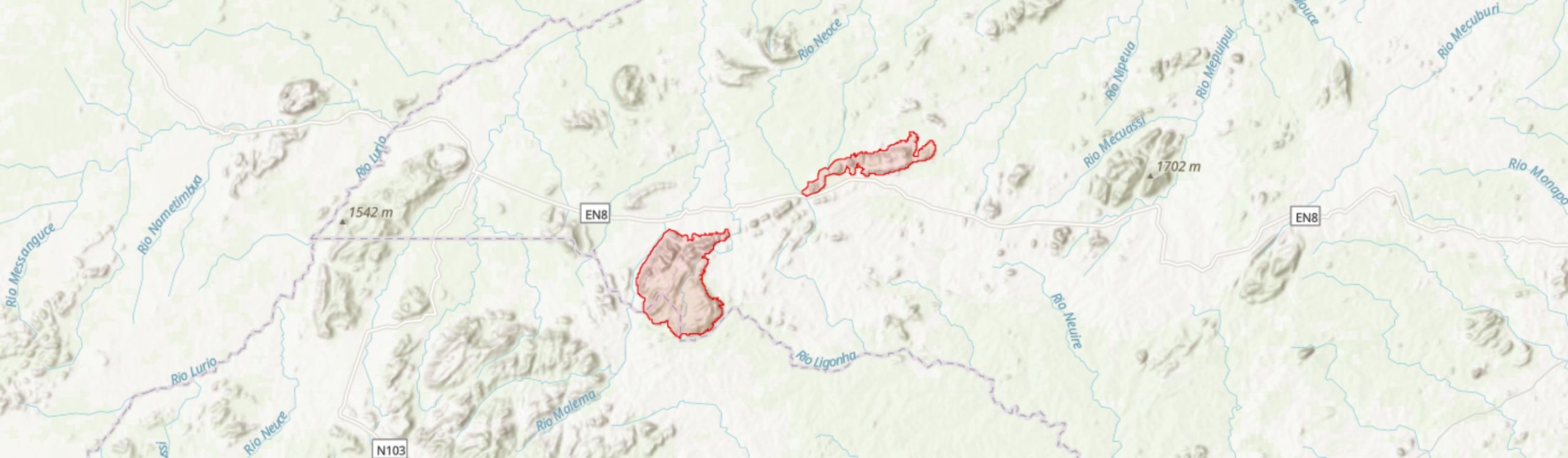
Central co-ordinates: 14.97373 S, 37.58455 E
Area: 379km²
Qualifying IPA Criteria
A(i)Site contains one or more globally threatened species
IPA assessment rationale
Inago-Merripa qualifies as an IPA under sub-criterion A(i), as it contains important populations of one Endangered species, Rytigynia torrei, and four Vulnerable species, Ammannia parvula, Cynanchum oresbium, Gladiolus zambesiacus and Encephalartos gratus. Although an additional Vulnerable species, Khaya anthotheca, is present at this site, this species has a widespread distribution and it is unlikely that 1% of the global or 5% of the national population is found here.
Overall, there are 10 endemic or near endemic species under sub-criterion B(ii), however, this represents only 2% of the national list of species of B(ii) qualifying species, lower than the 3% threshold required. It is highly likely that more endemic and near endemic species will be found at this site with further investigation, and it may well qualify under B(ii) in future.
Although there is mid-altitude montane forest present at this site, a habitat type of conservation importance nationally, it is heavily degraded and the remaining area does not trigger sub-criterion C(iii). However, this habitat should still be conserved, and restored where possible, given its high value for biodiversity and ecosystem services.
Site description
The Inago-Merripa Important Plant Area falls within Malema District in western Nampula Province. This IPA is 373 km2 in area consisting of two separate polygons: one encompassing Mount Inago (-15.07°, 37.40°) and another around Serra Merripa or Murripa (-14.85°, 37.80°). Geographically, these mountains are connected through a spine of inselbergs, however, there are densely populated areas and agricultural land intervening, so this has been excluded from the boundary.
Inago-Merripa falls within the proposed Mulanje-Namuli-Ribáuè Centre of Plant Endemism (Darbyshire et al. 2019). The IPA is towards the northern edge of this mountain chain, with Mount Naumli to the south-west and the Ribáuè Mountains to the north-east. Although Inago-Merripa has been delineated to avoid much of the cultivated areas surrounding, agriculture is commonplace on both mountains, and woodland and montane forests are heavily fragmented as a result. Despite the degradation of habitats, there are a number of rare and threatened species known from these mountains that merit recognition of the site as an IPA.
Botanical significance
Inago-Merripa hosts a number of rare and threatened species. The globally Endangered species Rytigynia torrei is of particular importance as it is only known from Serra Merripa and a single other location, Taratibu in Cabo Delgado Province (see The Quirimbas Inselbergs [MOZTIPA022]). R. torrei occurs on the ecotone between savanna and mid-altitude forest, both of which are highly disturbed habitats due to the expansion of machambas in this IPA (Darbyshire et al. 2019b). This species was last observed on Serra Merripa in 1967 (Torre & Correia #16555) but there has been little botanical collecting in this part of the IPA and so this species may well continue to exist there, particularly in less accessible areas of the mountain. Research should be undertaken to establish this species is still extant at this site and, if so, conservation would be required to prevent this species becoming Critically Endangered.
There are also five Vulnerable species present within this IPA. Both Ammannia parvula and Cynanchum oresbium are only known from Nampula Province, both occurring at only a single other locality outside this IPA. A further Vulnerable species, the cycad Encephalartos gratus is known in this IPA from Serra Merripa, although it may yet be found to occur on Mount Inago. This species is native to Mozambique and Malawi but is threatened by habitat clearance estimated to be reducing the area of occupancy by 30% per generation (Donaldson 2010).
Another Vulnerable species native to both Mozambique and Malawi, Gladiolus zambesiacus, was collected on Mount Inago (Matimele #2533). This species is currently known from less than 11 locations in montane and submontane areas of southern Malawi and northern Mozambique (Darbyshire et al. 2019b). There is only a single other confirmed locality for this species in Mozambique, nearby Mount Namuli [MOZTIPA004]. The Inago-Namuli specimens represent a distinct form, different from the Malawian specimens, with narrower leaves and thickened leaf margins and midribs (Goldblatt 1993). Further research may find the Inago-Namuli form represents a distinct species.
The final Vulnerable species present at this IPA, Khaya anthotheca, is widespread, found from Mozambique to tropical West Africa, but is threatened by overharvesting as a valuable hardwood species (Hawthorne 1998). There are nine Mozambican endemic species in total occurring within this IPA. The threatened species Ammannia parvula and Cynanchum oresbium are the most range limited of these endemics. Encephalartos turneri (LC) also has a narrow range, endemic to Nampula and Niassa provinces, but is abundant within this limited area (Bösenberg 2010). Alongside these endemic species is the near-endemic Euphorbia decliviticola (LC), known from a range of only 5,744 km2, predominantly in Mozambique with one location in Malawi (Osborne et al. 2019).
Justicia asystasioides, collected on Mount Inago in 2017 (Matimele #2537), is a further species of note. Although also native to Tanzania and Malawi, this IPA and Mount Mabu [MOZTIPA012] are the only known locations for this species in Mozambique. There are likely further species of conservation interest within the remaining forest fragments of Inago and Merripa. For example, Memecylon nubigenum (EN) and Pyrostria chapmanii (EN) occur on both Mount Namuli and Ribáuè, either side of this IPA, and so are likely to occur within Inago-Merripa. Further botanical collecting at this site, particularly on Serra Merripa, is of great urgency as habitat continues to be lost before its conservation value can be fully established.
Habitat and geology
Inago-Merripa IPA encompasses Mount Inago (1,870 m) and Serra Merripa (1,023 m), excluding the spine of inselbergs that run between these two peaks. The mountains are granite-porphyrite intrusions, dating from around 630 – 550 million years ago, in the surrounding 1,100 – 850 million year old Nampula and Namarroi series migmatites (Bayliss et al. 2010; Macey et al. 2010). Average temperatures for Malema district range from 15 – 22°C in June and July to 21 – 29°C in October. Rainfall can vary year on year but averages at 1,300 mm annually, with much of this falling between December and March (Bayliss et al. 2010; World Weather Online 2021). The mountains, however, also receive moisture from frequent mists (Torre & Correia #16564).
Biodiversity surveys of a range of taxa were conducted in 2009 by Bayliss et al. (2010), as part of this work the plant species that characterise the different ecosystems on Mount Inago were recorded. In contrast, there has been little botanical collecting on Serra Merripa, with many of the specimens dating from A. R. Torre’s visits in the 1960s. Much of the below description is based on the Inago survey work by Bayliss et al. (2010). It is highly likely that the species compositions of ecosystems on Serra Merripa are similar to those on Inago due to the short distance between them both, although Serra Merripa peaks at a lower altitude so montane elements will likely be absent or very limited.
Below 1,000m much of this IPA is covered by woodland vegetation, although this is highly fragmented by agriculture (Google Earth 2020). Woodland on the foothills and lower slopes of Mount Inago was described by Bayliss et al. (2010) as having distinct strata, with a 10 – 15 m canopy comprised of Parinari curatellifolia, Brachystegia sp., Albizia adianthifolia, Burkea africana and Syzygium cordatum. Although the Brachystegia species present in these woodlands was not identified by Bayliss et al. (2010), Lötter et al. (2021) state that B. torrei, and sometimes B. spiciformis and B. bussei, are present within this habitat type (categorised by Lötter et al. (2021) as Northern Inselberg Woodland). The mid-canopy is composed of species such as Protea petiolaris, Cussonia arborea, Vitex doniana and Strychnos sp., while herbs and grasses, such as Themeda triandra and Hyparrhenia spp., cover the ground layer.
At lower altitudes, this woodland transitions into miombo. It is likely that this miombo has a similar composition of the woodland of the footslopes, although Brachystegia is likely more dominant on the surrounding plain. It is clear from satellite imagery that this habitat, like the inselberg woodland, is also highly fragmented by agriculture (Google Earth 2020).
Bayliss et al. (2010) also made collections in the gallery forests on Mount Inago, with canopy trees reaching 15 – 30 m and including species such as Khaya anthotheca, Breonadia salicina, Englerophytum magalismontanum and Newtonia buchananii. The mid-canopy, between 8 – 15 m tall, consists of species such as Sterculia africana, Cussonia spicata, Trema orientalis and Anthocleista grandiflora with smaller shrubs and tree ferns occurring below. Collection data from Serra Merripa describe riverine soils as red clay (Torre & Paiva #10439), the habitat within these areas is otherwise largely undocumented, although likely bears similarities to those of Mount Inago.
At higher altitudes, between 1000 – 1600 m, there are patches of forest categorised by Bayliss et al. (2010) as “semi-deciduous, wet forest”. Canopy trees are relatively large, with DBH over 50 cm and height between 20 – 30 m. Species include Drypetes natalensis, Schefflera umbellifera and Newtonia buchananii. Forest on Serra Merripa is likely very similar, with this habitat described as dense fog forest including Newtonia buchananii, Ekebergia capensis and Khaya anthotheca (Torre & Correia #16583), although the latter species is likely associated more with riverine forest (Burrows et al. 2018). Smaller trees such as Myrianthus holstii occur in forest the understory on Mount Inago, while the herbaceous species in this forest are yet to be documented in any detail. Although mid-altitude forest was thought to have been extensive on these mountains, patches of forest are limited to around 1 – 10 ha in size and are now largely confined to inaccessible areas, below granite domes and in steep ravines (Bayliss et al. 2010). Due to extensive conversion of habitat on Serra Merripa, there appears to be little or even no montane forest remaining on this inselberg, while it was previously extensive on the south facing plateau of this inselberg (Google Earth 2020; Lötter et al. 2021).
In more exposed rocky areas, particularly on rocky slopes and granite domes above 1,500 m, the landscape is open (Google Earth 2020). Succulent Euphorbia, including E. corniculata and E. decliviticola, and Aloe species, including endemic species A. menyharthii subsp. ensifolia, occur in these areas. On high altitude plateaux tussocks of the sedge Coleochloa setifera are frequent. Exacum zombense (LC), a near-endemic, herbaceous species typical of seasonal seepages in the shallow soils of rock faces and outcrops, was recorded from high altitude wooded grassland on Mount Inago (Matimele #2529). Other rock-loving flora, such as Aeollanthus serpiculoides, Cyanotis lanata and Linderniella gracilis (Matimele #2528, #2525, #2526) have also been collected from these high-altitude areas. The Vulnerable species Ammannia parvula occurs on granite outcrops of Mount Inago, likely occurring in seasonal pools in the rocky landscape. Cycads are also present on exposed outcrops with Encephalartos turneri (LC) occurring on both mountains. E. gratus (VU) has also been recorded from the rocky slopes of Serra Merripa, further investigation may find this species is also present on Mount Inago.
Machambas occur throughout Inago-Merripa IPA, forming a patchwork within mid-altitude forest and lowland woodland habitats. On Mount Inago, these plots are mainly used to grow maize; however, other crops such as tomatoes, onions, green peppers, and beans are also grown. In these areas, irrigation systems are used to channel watercourses onto productive land (Bayliss et al. 2010).
Conservation issues
The habitats within this IPA are highly fragmented by agricultural expansion. Mid-altitude to montane forest is now largely restricted to small patches in inaccessible areas such as steep slopes below granite domes and in ravines. On Mount Inago forest patches are generally 1 – 5 ha in size but would have previously covered large areas of the mid-altitude plateaux (Bayliss et al. 2010). The forested areas of Inago became occupied during the Mozambican Civil War, as local people sought refuge in the relative security of this mountainous landscape. Following settlement by refugees, forests began to be cleared to make way for machambas (Bayliss et al. 2010). It is likely that the Serra Merripa also had areas of montane forest, particularly on the southern plateau below the rockier peaks (Lötter et al. 2021), however, much of this has now been cleared for agriculture (Google Earth 2020).
Clearing of montane habitats for machambas is of particular conservation concern, given the rare and threatened species that reside within these habitats, but also because a loss of forested areas may reduce the provision of ecosystem services, such as water regulation and soil stabilisation. Cultivation on the mountain also involves the irrigation of crops through redirecting water (Bayliss et al. 2010), which may reduce water availability for riverine habitats as well as for communities who live downstream, particularly in the dry season. On the other hand, the riverine forests are thought to direct carry volumes of water during the wet season (Bayliss et al. 2010), degradation of these areas could expose the mountain slopes to erosion and could cause flooding downstream. The use of fire to clear land in preparation for farming is an additional threat as it brings the risk of unintentional burns of larger swathes of land (Bayliss et al. 2010).
Bayliss et al. (2010) recommend that local authorities should encourage people to move agricultural land off the mountain and instead farm fertile areas of the surrounding plain, with support for from NGOs to develop more sustainable agriculture. However, much of the land surrounding the mountains is or has been used for farming already (Google Earth 2020), while the frequent mists and irrigation systems on the mountain likely support a more reliable harvest than those on the plains. People who farm on the mountains may, therefore, be resistant towards the idea of moving. A great deal of support and cooperation would be required to facilitate alternative, sustainable production systems for local people.
One project on nearby Mount Namuli could offer some guidance on balancing conservation with sustainable production and community development. NGOs Legado and Nitidæ are collaborating on a project, running between 2018 – 2022, to support communities around Namuli, through securing land rights for local people, improving healthcare provision and supporting greater market access. Alongside this, the project has been supporting communities in developing a long-term natural resource management plan while also working towards establishing the site as a Community Conservation Area (Nitidæ 2021). Some of the strategies employed by this project could also be applied within this IPA to support local environmental restoration and economic development.
Although this IPA does not fall within a protected area, Mount Inago has been recognised as a KBA. Amongst the triggers for this KBA are a species of frog, Nothophryne inagoensis (EN), and chameleon, Rhampholeon bruessoworum (CR), that are both known only from the forest fragments on Mount Inago and are both severely threatened by the continued encroachment of agriculture into these areas (IUCN SSC Amphibian Specialist Group 2019; Tolley et al. 2019). The presence of these species would also allow the KBA to also qualify as an Alliance of Zero Extinction site. In addition, the butterfly taxon Cymothoe baylissi subsp. monicae is known only from Mount Inago and Mount Mabu. As a sedentary species, which generally does not move between forest patches, C. baylissi subsp. monicae is at high risk of becoming locally extirpated on Mount Inago (Van Velzen et al. 2016). Protection of the remaining forest patches and restoring areas to reconnect these forest fragments is of great importance in preventing the extinction of these species.
Avian taxa recorded on Mount Inago include Thyolo Alethe (Chamaetylas choloensis - VU), with this IPA being the most easterly locality for this species, and East Coast Akalat (Sheppardia gunning - NT) (BirdLife International 2017, 2018). Both of these species were observed by Bayliss et al. (2010) in forest patches on the mountain, further highlighting the importance of these forests for their conservation value.
The landslide hazard, a measure of risk and impact of landslides on people and assets, was assessed as high to very high in this IPA (World Bank 2019). A geological analysis by Mizuno et al. (2018) found that Mount Inago is constantly displacing a few millimetres each year but is also at risk of a deep-seated landslide following an earthquake or heavy rainfall. Such a landslide is predicted to have the potential to displace up to 200 million m3 of debris, which would be catastrophic in scale. The authors state that the last such event occurred in 887 AD following an earthquake and moved an estimated 350 million m3 of debris. There may be little that can be done to prevent deep-seated landslides here, as the depth of the presumed slip surface is far beyond the roots of vegetation on this mountain, although changes in hydrology through habitat clearance may well have some impact. Further research to confirm the risk of landslide on this mountain is recommended by Mizuno et al. (2018). This risk should be assessed primarily for consideration of the safety of the people who live on and around Inago, for which such a disaster would cause huge loss of life and suffering, but would also be of importance for conservation planning, particularly if habitat protection or restoration could play any role in mitigation of landslide risk or magnitude. Ex situ conservation measures may also need to be considered for the highly threatened or site endemic species should there be a high risk of landslide in the near future.
Ecosystem services
The mountains of this IPA are important sources of water, not only for people who live and farm on their slopes but for those in nearby towns and villages. Parts of Malema town depend on water that originates from Mount Inago while agriculture in the valleys that fall between the inselbergs is strongly associated with streams and rivers originating from the mountains (Bayliss et al. 2010; Google Earth 2020). The water provision from these inselbergs is likely of great importance during the dry season, while farming on the mountain itself may provide greater food security than farming the surrounding plains, particularly as the mid-altitude plateaux receive frequent mists. However, the continued degradation of forest in these areas will likely increase evapotranspiration, lowering moisture availability, and increase soil erosion which in turn may reduce the viability of agriculture on the mountains and could reduce water availability for downstream communities.
Bayliss et al. (2010) observed evidence of large volumes of water moving through riverine forests during the wet season. It is likely these forests slow water flow during this season, mitigating against flooding in the valleys below.
Timber is extracted from this IPA, including commercial hardwoods (Bayliss et al. 2010). Timber species may include Khaya anthotheca, a globally Vulnerable species threatened by over-harvesting for hardwood (Hawthorne 1998), known from the riverine forests at this site. Overharvesting of this and other forest species may reduce water availability, which is likely of greater value as an ecosystem service to local communities that the value of the timber extracted (Bayliss et al. 2010).
Site assessor(s)
Sophie Richards, Royal Botanic Gardens, Kew
Iain Darbyshire, Royal Botanic Gardens, Kew
IPA criterion A species
| Species | Qualifying sub-criterion | ≥ 1% of global population | ≥ 5% of national population | 1 of 5 best sites nationally | Entire global population | Socio-economically important | Abundance at site |
|---|---|---|---|---|---|---|---|
| Rytigynia torrei Verdc. | A(i) |  |
|
|
 |
|
Unknown |
| Encephalartos gratus Prain | A(i) | |
|
|
|
|
Unknown |
| Cynanchum oresbium (Bruyns) Goyder | A(i) | |
|
|
|
|
Frequent |
| Ammannia parvula S.A.Graham & Gandhi | A(i) | |
|
|
|
|
Unknown |
| Khaya anthotheca C.DC. | A(i) | |
|
|
|
|
Frequent |
| Gladiolus zambesiacus Baker | A(i) | |
|
|
|
|
Unknown |
Rytigynia torrei Verdc.
Qualifying sub-criterion:
A(i)
≥ 1% of global population:
≥ 5% of national population:
1 of 5 best sites nationally:
Entire global population:
Socio-economically important:
Abundance at site:
Unknown
Encephalartos gratus Prain
Qualifying sub-criterion:
A(i)
≥ 1% of global population:
≥ 5% of national population:
1 of 5 best sites nationally:
Entire global population:
Socio-economically important:
Abundance at site:
Unknown
Cynanchum oresbium (Bruyns) Goyder
Qualifying sub-criterion:
A(i)
≥ 1% of global population:
≥ 5% of national population:
1 of 5 best sites nationally:
Entire global population:
Socio-economically important:
Abundance at site:
Frequent
Ammannia parvula S.A.Graham & Gandhi
Qualifying sub-criterion:
A(i)
≥ 1% of global population:
≥ 5% of national population:
1 of 5 best sites nationally:
Entire global population:
Socio-economically important:
Abundance at site:
Unknown
Khaya anthotheca C.DC.
Qualifying sub-criterion:
A(i)
≥ 1% of global population:
≥ 5% of national population:
1 of 5 best sites nationally:
Entire global population:
Socio-economically important:
Abundance at site:
Frequent
Gladiolus zambesiacus Baker
Qualifying sub-criterion:
A(i)
≥ 1% of global population:
≥ 5% of national population:
1 of 5 best sites nationally:
Entire global population:
Socio-economically important:
Abundance at site:
Unknown
IPA criterion C qualifying habitats
| Habitat | Qualifying sub-criterion | ≥ 5% of national resource | ≥ 10% of national resource | 1 of 5 best sites nationally | Areal coverage at site |
|---|---|---|---|---|---|
| Medium Altitude Moist Forest 900-1400 m | C(iii) | |
|
|
14 |
Medium Altitude Moist Forest 900-1400 m
Qualifying sub-criterion:
C(iii)
≥ 5% of national resource:
≥ 10% of national resource:
Areal coverage at site:
14
General site habitats
| General site habitat | Percent coverage | Importance |
|---|---|---|
| Forest - Subtropical/Tropical Moist Montane Forest | |
Minor |
| Rocky Areas - Rocky Areas [e.g. inland cliffs, mountain peaks] | |
Minor |
| Savanna - Moist Savanna | |
Major |
| Artificial - Terrestrial - Arable Land | |
Major |
Forest - Subtropical/Tropical Moist Montane Forest
Percent coverage:
Importance:
Minor
Rocky Areas - Rocky Areas [e.g. inland cliffs, mountain peaks]
Percent coverage:
Importance:
Minor
Savanna - Moist Savanna
Percent coverage:
Importance:
Major
Artificial - Terrestrial - Arable Land
Percent coverage:
Importance:
Major
Land use types
| Land use type | Percent coverage | Importance |
|---|---|---|
| Agriculture (arable) | |
Major |
Agriculture (arable)
Percent coverage:
Importance:
Major
Threats
| Threat | Severity | Timing |
|---|---|---|
| Agriculture & aquaculture - Annual & perennial non-timber crops - Small-holder farming | High | Ongoing - trend unknown |
| Biological resource use - Logging & wood harvesting | Low | Ongoing - trend unknown |
| Residential & commercial development - Housing & urban areas | Low | Ongoing - trend unknown |
| Transportation & service corridors - Roads & railroads | Low | Past, not likely to return |
| Natural system modifications - Dams & water management/use - Abstraction of surface water (agricultural use) | Medium | Ongoing - trend unknown |
| Geological events - Avalanches/landslides | Unknown | Future - inferred threat |
Agriculture & aquaculture - Annual & perennial non-timber crops - Small-holder farming
Severity:
High
Timing:
Ongoing - trend unknown
Biological resource use - Logging & wood harvesting
Severity:
Low
Timing:
Ongoing - trend unknown
Residential & commercial development - Housing & urban areas
Severity:
Low
Timing:
Ongoing - trend unknown
Transportation & service corridors - Roads & railroads
Severity:
Low
Timing:
Past, not likely to return
Natural system modifications - Dams & water management/use - Abstraction of surface water (agricultural use)
Severity:
Medium
Timing:
Ongoing - trend unknown
Geological events - Avalanches/landslides
Severity:
Unknown
Timing:
Future - inferred threat
Conservation designation
| Designation name | Protected area | Relationship with IPA | Areal overlap |
|---|---|---|---|
| Mount Inago | Key Biodiversity Area | IPA encompasses protected/conservation area | 351 |
Mount Inago
Protected area:
Key Biodiversity Area
Relationship with IPA:
IPA encompasses protected/conservation area
Areal overlap:
351
Management type
| Management type | Description | Year started | Year finished |
|---|---|---|---|
| No management plan in place | |
|
No management plan in place
Year started:
Year finished:
Bibliography
Trees and Shrubs Mozambique
Google Earth Satellite Imagery
Encephalartos gratus. The IUCN Red List of Threatened Species 2010: e.T41916A10594309
Disaster Risk Profile: Mozambique
Khaya anthotheca. The IUCN Red List of Threatened Species 1998: e.T32235A9690061
Historical Vegetation Map and Red List of Ecosystems Assessment for Mozambique – Version 1.0 – Final report
Biodiversity and conservation of Mount Inago, Mozambique
Darwin Initiative Award 15/036: Monitoring and Managing Biodiversity Loss in South-East Africa's Montane Ecosystems Available online
Sheppardia gunningi (amended version of 2016 assessment). The IUCN Red List of Threatened Species 2017: e.T22709650A111057443
Chamaetylas choloensis. The IUCN Red List of Threatened Species 2018: e.T22709004A131333396
Encephalartos turneri. The IUCN Red List of Threatened Species 2010: e.T41946A10608314
Nothophryne inagoensis. The IUCN Red List of Threatened Species 2019: e.T149286395A149288435
Mesoproterozoic geology of the Nampula Block, northern Mozambique: Tracing fragments of Mesoproterozoic crust in the heart of Gondwana
Precambrian Research, Vol 182, page(s) 124-148
Landslide Survey and Scal Estimate by DInSAR, GNSS, and Airborne Laser Before Landslide Failure - Landslide Survey of Mt. Inago
NAMULI SKY ISLAND - Creation of a new protected area around Mount Namuli – Nitidæ
Euphorbia decliviticola. The IUCN Red List of Threatened Species 2019: e.T120955505A12098022
Rhampholeon bruessoworum. The IUCN Red List of Threatened Species 2019: e.T61366030A149766721
Description of a new Cymothoe Hübner, 1819 from northern Mozambique (Lepidoptera: Nymphalidae: Limenitidinae)
Metamorphosis, Vol 27, page(s) 34-41 Available online
Malema Monthly Climate Averages, Niassa, MZ.
Gladiolus zambesiacus. The IUCN Red List of Threatened Species 2018: e.T108615648A108620157
Iridaceae (Part 4). Flora Zambesiaca. Volume 12
Rytigynia torrei. The IUCN Red List of Threatened Species 2019: e.T136535757A136538308
The endemic plants of Mozambique: Diversity and conservation status
PhytoKeys, Vol 136, page(s) 45–96 Available online


Recommended citation
Sophie Richards, Iain Darbyshire (2024) Tropical Important Plant Areas Explorer: Mount Inago and Serra Merripa (Mozambique). https://tipas.kew.org/site/mount-inago-and-serra-merripa/ (Accessed on 27/07/2024)