Country: Mozambique
Administrative region: Zambézia (Province)
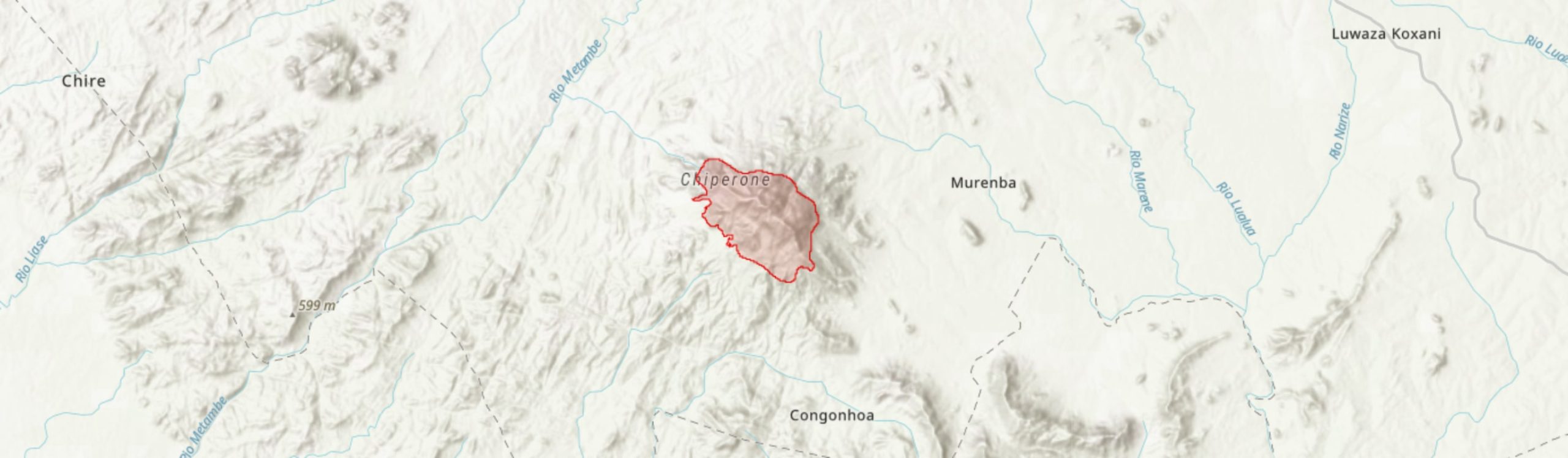
Central co-ordinates: 16.48144 S, 35.71007 E
Area: 24.2km²
Qualifying IPA Criteria
A(i)Site contains one or more globally threatened species, C(iii)Site contains nationally threatened or restricted habitat or vegetation types, AND/OR habitats that have severely declined in extent nationally
IPA assessment rationale
Mount Chiperone qualifies as an IPA under criteria A and C. The massif supports three sub-criterion A(i) species: Coffea salvatrix (EN), Prunus africana (VU) and Pavetta chapmanii (VU). Much of the Timberlake et al. (2007) checklist of plants is yet to be assessed for the IUCN Red List, and so it is likely that more species meet criterion A(i) but are in need of assessment.
This site also qualifies under criterion C(iii) due to the large extent of mid-altitude montane forest and the presence of high- altitude montane forest, both of which are range restricted and nationally threatened habitats.
Site description
Mount Chiperone is an isolated peak located in Milange District, Zambézia Province, Mozambique. This inselberg falls within the Mulanje-Namuli-Ribaue centre of endemism- a chain of mountains from southern Malawi to northern Mozambique where a high number of endemic or near endemic plant species are located (Darbyshire et al. 2019). Two villages are situated to the south of the mountain, Sabelua and Marega, each with associated agricultural land in the surrounding area. Drainage from the mountain gives rise to the Rio Macololo and the Rio Muse in the south-west, both of which are tributaries of the Shire River in Malawi.
The IPA is 24.2 km2 in area and encompasses the montane forests on the mid to high altitude slopes of the mountain. These forests at this site are of conservation importance due to their large extent of mostly undisturbed vegetation across an altitudinal gradient. Much of this area is above 900 m altitude, peaking at 2,054 m above sea level. The miombo woodland that surrounds the moist forest has largely been excluded. This area is used by local people for subsistence agriculture, particularly on the southern and western slopes and in some valleys to the north, however, the woodland fragments that remain provide an important ecological buffer for the forest in the IPA above (Timberlake et al. 2007).
Botanical significance
The main botanical significance of Mount Chiperone is the expansive area of undisturbed mid- to high-altitude humid forest, providing an uninterrupted forest transition from around 1,000 to 2,000 m above sea level. As much of the forests at this site are regarded as sacred by local people, they are largely in pristine condition. Chiperone represents one of the five best nationally for montane forest, with an extent of around 1.7 km2 of forest above 1,600m altitude, while it is also only slightly below the threshold for qualifying as one of the five best sites for mid-altitude forest, with an estimated 9.4 km2 of habitat.
Although there are currently no plant species known from only this site, it is home to some globally threatened species. Two of these threatened species are used directly by people: Prunus africana (VU) and Coffea salvatrix (EN). The medicinal bark of P. africana was previously exported at high volumes to Europe and the United States to treat benign prostate hyperplasia before an export ban was implemented. This species has a long history of use in traditional healing and as a timber tree throughout its native range, although it is not currently thought to be under threat from commercial harvesting at this site (Jimu 2011). Coffea salvatrix, or Mukofi, is a crop wild relative of commercial Arabica and Robusta coffees and may have some potential as a specialist coffee, particularly as it is a drought-tolerant species (O’Sullivan & Davis 2017; Timberlake et al. 2016). A third threatened species, Pavetta chapmanii (VU), is only known from six locations within the Mulanje-Namuli-Ribaue chain of mountains (Timberlake 2020). All three of these forest species are threatened by conversion of habitat to agriculture.
In addition, Chiperone represents the only confirmed Mozambican populations of three species as yet unassessed for the IUCN Red List, Erica microdonta, Cyperus amauropus and Pollia condensata, representing the southernmost collections within their respective ranges, while collections of Abrus melanospermus subsp. suffruticosus and Cyrtorchis arcuata subsp. whytei on Chiperone both represent range extensions for these subspecies (Harris et al. 2011). A total of 229 species were included in a checklist of plants above 800 m on Chiperone compiled by Timberlake et al. (2007), after a scientific expedition in 2006. Previous scientific expeditions to Chiperone have been focused on avifauna, with four visits recorded between 1950 and 2005. There are still large areas of this mountain, particularly to the north-west, where botanical inventory has yet to be undertaken, it is therefore likely that the checklist will continue to grow and include more threatened and rare plant species.
Habitat and geology
Inventory work was undertaken in 2006 by Timberlake et al. (2007) documenting many of the key species in ecosystems on the mountain. The following habitat description is based upon this account.
The vegetation on Chiperone varies with altitude. Mid-altitude forest, between 1,000 – 1,600 m, is dominated by tree species such as Newtonia buchananii, Strombosia scheffleri, Rinorea convallarioides and Chrysophyllum gorungosanum. The understory is open and dominated by Dracaena fragrans and Pseuderanthemum subviscosum. The mid-slopes have shallow soils due to steep slopes, which may explain the observed dominance of trees with low trunk diameters.
At higher altitudes, above 1,600 m, the forest composition changes, with shorter and more sclerophyllous tree species dominating including Peddiea africana, Diospyros whyteana, Maytenus undata, M. acuminata, Myrsine africana, Ochna holstii, Vepris bachmannii and Olea capensis subsp. macrocarpa. There is a greater incidence of fruticose lichens (thought to be Usnea spp.) and understory ferns here, probably due to the lower temperatures and frequent moist air derived from low cloud cover.
At the exposed peak, between 1,900 and 2,000 m, there is a dense thicket vegetation, primarily of Erica microdonta, with Aloe arborescens forming decumbent masses. Fruticose lichens are also common at this altitude, again these are thought to be Usnea. Other exposed outcrops are rare as even the most inaccessible ridges are covered by woody vegetation. Where rock is exposed, the plant community consists of Aloe, grasses, sedges (particularly Coleochloa, probably C. setifera) and low shrubs. There is a small patch of Acacia abyssinica woodland, which is confined to one south-easterly ridge as far as is understood. This woodland is of particular note due to the high number of ephiphytic ferns, orchids and lichens. The root parasite Sarcophyte sanguinea subsp. piriei is also common.
At the very edges of this IPA, and surrounding its boundaries, miombo woodland dominates. Much of this vegetation consists of Brachystegia species and while this plant community is common throughout southern Africa, it has an important role as a buffer to the forested areas above. Where soils are fertile, this woodland has been cleared for cultivation. Extensive clearing near the settlements on the southern and eastern slopes has been observed, however, much of this has been excluded from the IPA. As soils become exhausted, expansion into the forested areas at higher altitudes, which are largely undisturbed at present, may occur.
The soils throughout the IPA are quite shallow. Chiperone is comprised of synetite (Jurassic/Cretaceous period, c.150 Mya) and is an igneous intrusion into the surrounding country rock, migmatites of the Namarroi Series (850 – 1,100 Mya). This geology is unlike most of the massifs and hills in northern Mozambique, which are comprised mostly of granites and migmatites. That said, this geology is shared with the nearby Mount Tembe, Morrumbala and Serra Tumbine at Milange along with sections of Mount Mulanje, across the border in Malawi, and Mount Gorongosa in central Mozambique.
Climate data from the Chiperone itself is not available. Temperatures in nearby Milange town range from 17.1°C to 28.9°C, with annual rainfall averaging it 1,734 mm, although annual precipitation on the lower slopes of Chiperone is thought to be much lower around 1,000 mm.
Conservation issues
This IPA does not fall within a protected area and is under no formal conservation measures. The forest and its wildlife fall under the Forest and Wildlife Act (Lei. 10/99 of 1999) and, in most areas, The Environmental Act (Lei. 20/97 of 1997), the latter prohibiting cultivation of annual crops on slopes steeper than 7° and perennial crops on slopes steeper than 14° (Timberlake et al. 2007; ECOLEX.org 2020).
Mount Chiperone has been designated as an Important Bird Area (IBA), with the IPA described here falling completely within the boundaries of the IBA. In terms of bird diversity, this site hosts the only known population of the White-winged Apalis (Apalis chariessa - NT) in Mozambique (BirdLife International 2001). In addition, the largest population of Thyolo Alethe (Chamaetylas choloensis - VU) globally is known from Chiperone. Elsewhere this species is greatly threatened by deforestation, particularly in Malawi (BirdLife International 2018).
This site is also recognised as a Key Biodiversity Area (KBA) with trigger species including C. choloensis and three reptile species that are only known from Mount Chiperone. One of these species, Mount Chiperone Pygmy Chameleon (Rhampholeon nebulauctor), has been assessed as globally Vulnerable (Tolley et al. 2019). The remaining two trigger species are the recently described Nadzikambia chiperone and Lygodactylus chiperone (Tolley 2017, 2018). The presence of these unique reptile species allows the site to qualify as a KBA under the irreplaceability criterion (Tolley 2017). A number of small mammals have been recorded from the massif, and Leopard (Panthera pardus - VU) are reported to be common (Timberlake et al. 2007).
At lower altitudes, below 800 m, much of the woodland has been cleared for cultivation. However, wood extraction above ca. 1,300 m is limited due to the steep inaccessible terrain and a local reluctance to enter the dense forest due to spiritual beliefs in the area (Spottiswoode et al. 2008). At the margins of the forest, however, there has been some minor tree felling but a greater threat is posed by uncontrolled fires, particularly in the gullies. Fires are used to clear areas for subsistence agriculture at lower altitudes. However, these fires have been known to spread up the mountain, with evidence of burning 50 m in from the margins of the moist forest (Timberlake et al. 2007). These uncontrolled fires result in the loss of humus and moisture in the soils, and the clearing of understory plants. Edge and gap species, such as Trema orientalis and Albizia gummifera, can then establish and prevent forest regeneration by outcompeting forest tree species (Timberlake et al. 2007).
Despite the shallow and rocky soils, local people establish machambas on steep slopes of the mountain for cultivating maize and beans. With good rainfall, the larger fields surrounding the mountain produce higher yields than the small clearings above. However, when there is little rainfall, the machambas on the slopes will still yield some food, due to the moister air and reduced evapotranspiration on the mountain slopes, while the crops in the surrounding peneplain are liable to fail in these conditions (Timberlake et al. 2007). There could therefore be an increasing threat of encroachment from agriculture, particularly if drought stress becomes more common in the area. As Chiperone is linked to both weather patterns in the local area (see “Key Ecosystem Services”) and drainage of clean water into nearby rivers, encroachment of agriculture could further exacerbate water shortages, and therefore the environmental pressures, in the local and wider area.
Ecosystem services
Local villages to the south and east, with a total population of 1,000 to 2,000 residents, depend on the streams coming off the mountain as their only source of clean water for several kilometres (Timberlake et al. 2007). Local people also depend on this water source to support subsistence agriculture, particularly on machambas on steeper slopes that are an important food source during drier years. In Malawi, “chiperone” refers to a misty weather system that forms over Mount Chiperone and crosses into Malawi. It is thought that this weather system is an important source of moisture for the tea plantations in Malawi during the dry season (Timberlake et al. 2007).
Due to locally held spiritual beliefs, people from the surrounding villages are generally reluctant to enter the forested areas above ca. 1,300 m (Spottiswoode et al. 2008). The humid forest on Chiperone may therefore be regarded as a sacred forest using the criteria suggested by Virtanen (2002).
Timber is rarely harvested from within the IPA boundary, and collection of plants for medicinal properties occurs mostly in the surrounding woodland areas. Bushmeat hunting, however, does take place on higher slopes, although this practice is limited to a small group of local residents. Bushbuck (Tragelaphus scriptus), Bushpig (Potamochoerus larvatus), and Duiker (Cephalophus spp.) are caught using gin traps (Timberlake et al. 2007). Honey is also reported to be collected in the forest (Spottiswoode et al. 2008).
Deforestation on nearby Serra Tumbine has resulted in catastrophic landslips above Milange town, suggesting that the forest on Chiperone may also play an important role in stabilising the substrate on the mountain (Timberlake et al. 2007).
There is no known tourism in this area.
Site assessor(s)
Sophie Richards, Royal Botanic Gardens, Kew
Iain Darbyshire, Royal Botanic Gardens, Kew
Hermenegildo Matimele, Instituto de Investigação Agrária de Moçambique
IPA criterion A species
| Species | Qualifying sub-criterion | ≥ 1% of global population | ≥ 5% of national population | 1 of 5 best sites nationally | Entire global population | Socio-economically important | Abundance at site |
|---|---|---|---|---|---|---|---|
| Coffea salvatrix Swynn. & Phillipson | A(i) |  |
 |
|
|
|
Frequent |
| Pavetta chapmanii Bridson | A(i) | |
|
|
|
|
Unknown |
| Prunus africana (Hook.f.) Kalkman | A(i) | |
|
|
|
|
Unknown |
Coffea salvatrix Swynn. & Phillipson
Qualifying sub-criterion:
A(i)
≥ 1% of global population:
≥ 5% of national population:
1 of 5 best sites nationally:
Entire global population:
Socio-economically important:
Abundance at site:
Frequent
Pavetta chapmanii Bridson
Qualifying sub-criterion:
A(i)
≥ 1% of global population:
≥ 5% of national population:
1 of 5 best sites nationally:
Entire global population:
Socio-economically important:
Abundance at site:
Unknown
Prunus africana (Hook.f.) Kalkman
Qualifying sub-criterion:
A(i)
≥ 1% of global population:
≥ 5% of national population:
1 of 5 best sites nationally:
Entire global population:
Socio-economically important:
Abundance at site:
Unknown
IPA criterion C qualifying habitats
| Habitat | Qualifying sub-criterion | ≥ 5% of national resource | ≥ 10% of national resource | 1 of 5 best sites nationally | Areal coverage at site |
|---|---|---|---|---|---|
| Medium Altitude Moist Forest 900-1400 m | C(iii) | |
|
|
9.4 |
| Montane Moist Forest >1600 m | C(iii) | |
|
|
1.7 |
Medium Altitude Moist Forest 900-1400 m
Qualifying sub-criterion:
C(iii)
≥ 5% of national resource:
≥ 10% of national resource:
Areal coverage at site:
9.4
Montane Moist Forest >1600 m
Qualifying sub-criterion:
C(iii)
≥ 5% of national resource:
≥ 10% of national resource:
Areal coverage at site:
1.7
General site habitats
| General site habitat | Percent coverage | Importance |
|---|---|---|
| Forest - Subtropical/Tropical Moist Montane Forest | |
Major |
| Rocky Areas - Rocky Areas [e.g. inland cliffs, mountain peaks] | |
Minor |
| Artificial - Terrestrial - Arable Land | |
Minor |
| Shrubland - Subtropical/Tropical High Altitude Shrubland | |
Minor |
| Savanna - Moist Savanna | |
Major |
Forest - Subtropical/Tropical Moist Montane Forest
Percent coverage:
Importance:
Major
Rocky Areas - Rocky Areas [e.g. inland cliffs, mountain peaks]
Percent coverage:
Importance:
Minor
Artificial - Terrestrial - Arable Land
Percent coverage:
Importance:
Minor
Shrubland - Subtropical/Tropical High Altitude Shrubland
Percent coverage:
Importance:
Minor
Savanna - Moist Savanna
Percent coverage:
Importance:
Major
Land use types
| Land use type | Percent coverage | Importance |
|---|---|---|
| Agriculture (arable) | |
Minor |
Agriculture (arable)
Percent coverage:
Importance:
Minor
Threats
| Threat | Severity | Timing |
|---|---|---|
| Agriculture & aquaculture - Annual & perennial non-timber crops - Small-holder farming | Low | Ongoing - trend unknown |
| Natural system modifications - Fire & fire suppression - Increase in fire frequency/intensity | Medium | Ongoing - trend unknown |
Agriculture & aquaculture - Annual & perennial non-timber crops - Small-holder farming
Severity:
Low
Timing:
Ongoing - trend unknown
Natural system modifications - Fire & fire suppression - Increase in fire frequency/intensity
Severity:
Medium
Timing:
Ongoing - trend unknown
Conservation designation
| Designation name | Protected area | Relationship with IPA | Areal overlap |
|---|---|---|---|
| Mount Chiperone | Important Bird Area | protected/conservation area encompasses IPA | 24 |
| Mount Chiperone | Key Biodiversity Area | protected/conservation area encompasses IPA | 24 |
Mount Chiperone
Protected area:
Important Bird Area
Relationship with IPA:
protected/conservation area encompasses IPA
Areal overlap:
24
Mount Chiperone
Protected area:
Key Biodiversity Area
Relationship with IPA:
protected/conservation area encompasses IPA
Areal overlap:
24
Management type
| Management type | Description | Year started | Year finished |
|---|---|---|---|
| No management plan in place | |
|
No management plan in place
Year started:
Year finished:
Bibliography
Plant conservation in communities on the Chimanimani footslopes, Mozambique. Report prepared for Darwin Initiative Award 2380: Balancing Conservation and Livelihoods in the Chimanimani Forest Belt, Mozambique.
The endemic plants of Mozambique: diversity and conservation status
PhytoKeys, Vol 136, page(s) 45-96 Available online
Coffea salvatrix. The IUCN Red List of Threatened Species 2017: e.T18290408A18539335
Important Bird Areas Factsheet: Mount Chiperone.
New Species and Range Extensions from Mt Namuli, Mt Mabu and Mt Chiperone in Northern Mozambique.
Kew Bulletin, Vol 66, page(s) 241-251 Available online
Threats and Conservation Strategies for the African Cherry (Prunus Africana) in Its Natural Range- A Review.
Journal of Ecology and The Natural Environment, Vol 3, page(s) 118-130
Threatened Bird Species on Two Little-Known Mountains (Chiperone and Mabu) in Northern Mozambique.
Ostrich, Vol 79, page(s) 1-7
Pavetta chapmanii. The IUCN Red List of Threatened Species 2020: e.T146652565A146819426
Biodiversity and Conservation of Mount Chiperone, Mozambique
Darwin Initiative Award 15/036: Monitoring and Managing Biodiversity Loss in South-east Africa's Montane Ecosystems, page(s) 1-33 Available online
The Role of Customary Institutions in the Conservation of Biodiversity: Sacred Forest in Mozambique
Environmental Values, Vol 11, page(s) 227-241
Hidden under the Clouds: Species Discovery in the Unexplored Montane Forests of Mozambique to Support New Key Biodiversity Areas
Into the clouds: Surveying the Sky Islands of Mozambique (Part 1)
Rhampholeon nebulauctor. The IUCN Red List of Threatened Species 2019: e.T61365784A149767278


Recommended citation
Sophie Richards, Iain Darbyshire, Hermenegildo Matimele (2024) Tropical Important Plant Areas Explorer: Mount Chiperone (Mozambique). https://tipas.kew.org/site/mount-chiperone/ (Accessed on 27/07/2024)