Country: Cameroon
Administrative region: Centre (Region)
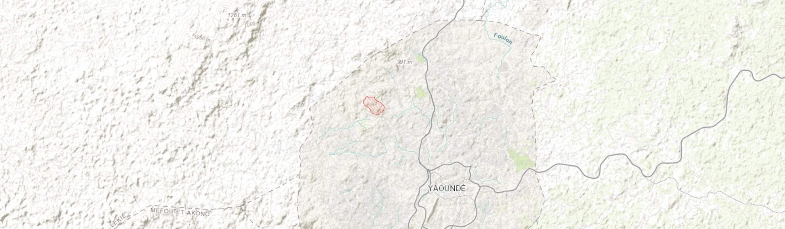
Central co-ordinates: 3.90593 N, 11.48379 E
Area: 1.25km²
Qualifying IPA Criteria
A(i)Site contains one or more globally threatened species
IPA assessment rationale
Mount Mbankolo qualifies as a potential IPA under criterion A(i) due to the presence of at least two globally threatened species, Craterostigma yaundense and Eragrostis raynaliana. Both of these are known from very few other locations and are also thought to be scarce and threatened at those sites. Craterostigma yaundense is endemic to Cameroon.
Site description
Mount Mbankolo is one of the "seven hills" of Yaoundé, the capital of Cameroon. These hills are part of a larger group of Yaoundé mountains fringing the western side of the city. Mount Mbankolo is northwest of the city centre, next to Mt Febe and also close to the Presidential Palace. The site rises to over 1,000 m.
Botanical significance
Yaoundé has been an area of important botanical collections since the 1890s. While many of these earlier collections can not be pinpointed to particular locations, it is likely that many species were from the forested inselbergs which provide additional ecological niches for many species to those in the surrounding lowland forest. Subsequent collecting has provided records of many threatened species from these hills. Two globally endangered species are known from Mount Mbankolo and it is possible that other taxa collected from neighbouring hills may also occur here.
Habitat and geology
The hills around Yaounde rise from the South Cameroon Plain between the Sanaga fault and the north-thrusting Congo craton. They are formed from high grade metamorphic rocks, mainly granulites and migmatites also referred to as embrichite gneiss (Achoundong, 1985), formed from sedimentary and igneous protoliths and apparently dating from around 600 mya (Nzenti, 1988; Tchouatcha et al., 2018; Ngnotue, 2012).
Precipitation in Yaoundé is 1,605 mm per annum, falling in a bimodal pattern with a small (March-June) and greater (September-November) wet season interspersed with a drier period (July-August) and then a second more severe dry period between December and February when mean monthly rainfall drops below the relatively flat mean monthly temperature curve (range: 22.8–25.47 °C) on a Walter-Leith type chart (Simo et al., 2009; Bissaya et al., 2014; Noumi, 2015). This is below the level of rainfall normally thought necessary to sustain evergreen tropical forest (Cheek et al., 2011), although the level may be higher on the summits due to orographic precipitation (Madiapevo et al., 2017; Simo et al 2009). The original forest was probably semi-deciduous (Achoundong, 1985) but has been heavily degraded through timber and wood extraction and cultivation.
Conservation issues
The vegetation of Mount Mbankolo can be seen from satellite images to have been degraded by cultivation, fire and logging, with subsequent soil erosion. Intense population pressure in Yaoundé has led to increasing "urban front" advancement on steep slopes and marshy areas (Tiafack & Mbon, 2017; Nkwemoh, C.A & Tchindjang, M., 2018). Up to c. 830 m Mbankolo is densely settled around much of its perimeter, and buildings and cultivation can also be seen much higher on parts of the mountain. Several cell phones or radio masts are present on the summit with associated service roads.
Pressure for development and safer conditions in the Mbankolo neighbourhood could lead to further loss of habitat. Planting of Eucalyptus trees has been instigated in other areas of the city for fuel and landslide and flood protection but conservation of natural vegetation and limiting of settlement on slopes might be better solutions.
Ecosystem services
As is the case with the other hills around Yaoundé, there is a high risk of landslides due to steep terrain and impervious clay beneath permeable laterite soils. Such events have claimed lives and caused extensive damage such as the Oyom Abang landslide in western Yaoundé in September 1990 which killed five people (Zogning et al., 1900; Mukenga et al., 2016; Bissaya et al., 2014). Preservation of existing forest and primary vegetation is important to preventing such disasters and flash flooding (Lachenaud et al., 2013).
The site contributes to air quality and provides fresh water. In a rapidly growing metropolitan area it is also an important recreational and educational resource for the growing population; the survival of rare species and primary vegetation greatly increases the value of such sites over planted park-land or forest plantation. The habitat is of importance to botanists and forestry students at the city's universities and institutes for educational and training purposes.
Site assessor(s)
Assessed by:
Bruce Murphy, Royal Botanic Gardens, Kew
Martin Cheek, Royal Botanic Gardens Kew
IPA criterion A species
| Species | Qualifying sub-criterion | ≥ 1% of global population | ≥ 5% of national population | 1 of 5 best sites nationally | Entire global population | Socio-economically important | Abundance at site |
|---|---|---|---|---|---|---|---|
| Craterostigma yaundense (S.Moore) Eb.Fisch., Schäferh. & Kai Müll. | A(i) |  |
|
|
 |
|
|
| Eragrostis raynaliana Lebrun | A(i) | |
|
|
|
|
Craterostigma yaundense (S.Moore) Eb.Fisch., Schäferh. & Kai Müll.
Qualifying sub-criterion:
A(i)
≥ 1% of global population:
≥ 5% of national population:
1 of 5 best sites nationally:
Entire global population:
Socio-economically important:
Abundance at site:
Eragrostis raynaliana Lebrun
Qualifying sub-criterion:
A(i)
≥ 1% of global population:
≥ 5% of national population:
1 of 5 best sites nationally:
Entire global population:
Socio-economically important:
Abundance at site:
General site habitats
| General site habitat | Percent coverage | Importance |
|---|---|---|
| Artificial - Terrestrial - Subtropical/Tropical Heavily Degraded Former Forest | |
Artificial - Terrestrial - Subtropical/Tropical Heavily Degraded Former Forest
Percent coverage:
Importance:
Land use types
| Land use type | Percent coverage | Importance |
|---|---|---|
| Harvesting of wild resources | |
Harvesting of wild resources
Percent coverage:
Importance:
Threats
| Threat | Severity | Timing |
|---|---|---|
| Residential & commercial development - Housing & urban areas | High | Ongoing - increasing |
| Agriculture & aquaculture - Annual & perennial non-timber crops - Small-holder farming | High | Ongoing - trend unknown |
| Energy production & mining - Mining & quarrying | Medium | Future - inferred threat |
| Biological resource use - Logging & wood harvesting - Unintentional effects: subsistence/small scale (species being assessed is not the target) [harvest] | High | Ongoing - trend unknown |
| Natural system modifications - Fire & fire suppression - Increase in fire frequency/intensity | High | Ongoing - trend unknown |
| Geological events - Avalanches/landslides | High | Future - inferred threat |
| Residential & commercial development - Commercial & industrial areas | Medium | Ongoing - trend unknown |
Residential & commercial development - Housing & urban areas
Severity:
High
Timing:
Ongoing - increasing
Agriculture & aquaculture - Annual & perennial non-timber crops - Small-holder farming
Severity:
High
Timing:
Ongoing - trend unknown
Energy production & mining - Mining & quarrying
Severity:
Medium
Timing:
Future - inferred threat
Biological resource use - Logging & wood harvesting - Unintentional effects: subsistence/small scale (species being assessed is not the target) [harvest]
Severity:
High
Timing:
Ongoing - trend unknown
Natural system modifications - Fire & fire suppression - Increase in fire frequency/intensity
Severity:
High
Timing:
Ongoing - trend unknown
Geological events - Avalanches/landslides
Severity:
High
Timing:
Future - inferred threat
Residential & commercial development - Commercial & industrial areas
Severity:
Medium
Timing:
Ongoing - trend unknown
Management type
| Management type | Description | Year started | Year finished |
|---|---|---|---|
| No management plan in place | |
|
No management plan in place
Year started:
Year finished:
Bibliography
The Plants of Mefou Proposed National Park, Yaoundé, Cameroon
The catastrophic geomorphological processes in humid tropical Africa: A case study of the recent landslide disasters in Cameroon
Sedimentary Geology, Vol 199, page(s) 13 – 27 Available online
Spatial Analysis of the Landslide Risk in the Cameroon Volcanic Line (CVL)
Utilisation des données géologiques et gestion des informations multi-sources pour l’analyse de l’aléa glissement de terrain/éboulement dans le secteur Nord-Ouest de la région de Yaoundé
Afrique SCIENCE, Vol 10(3), page(s) 113 - 133
Urban Growth and Front Development on Risk Zones: GIS Application for Mapping of Impacts on Yaounde North Western Highlands, Cameroon
Current Urban Studies, Vol 5(2), page(s) 217-235
Urban sprawl and agriculture: A case study of the Yaounde metropolis (Cameroon)
Revue Scientifique et Technique Forêt et Environnement du Bassin du Congo, Vol 10, page(s) 45-58.
The Impact of Urbanization on the Vegetation of Yaounde, (Cameroon)
International Journal of Innovative Research & Development, Vol 6(5), page(s) 6-18
Les forêts sommitales du Cameroun: Végétation et flore des Collines de Yaoundé.
Bois et forêt des tropiques, Vol 247, page(s) 37-52
New records for the flora of Cameroon, including a new species of Psychotria (Rubiaceae) and range extensions for some rare species
Plant Ecology and Evolution, Vol 146 (1), page(s) 121–133
Floristic structure and diversity of a tropical sub-montane evergreen forest, in the Mbam minkom massif (Western Yaoundé).
Journal of Biology and Life Science, Vol 6(1), page(s) 149-193
The Orchid Flora of the Mbam Minkom Hills (Yaoundé, Cameroon)
Belgian Journal of Botany, Vol 142(2), page(s) 111-123
Origin and evolution of the late Precambrian high-grade Yaounde gneisses (Cameroon).
Precambambrian Research, Vol 38, page(s) 91-109
Preserved Sedimentary Features in the Pan-African High-Grade Metamorphic Rocks from the Yaoundé Series (Cameroon)
Journal of Geosciences and Geomatics, Vol 6(3), page(s) 94-102
Geochemistry and geochronology of Peraluminous High-K Granitic Leucosomes of Yaoundé Series ) Cameroon. Evidence for a Unique Pan-African Magmatism and Melting Event in North Equatorial Fold Belt.
International Journal of Geosciences, Vol 3, page(s) 525-548
Plant Woody Diversity of the Highest Summit Forest (1156 m), in the Kala Massif, Western Yaoundé
International Journal of Current Research in Biosciences and Plant Biology, Vol 4(10), page(s) 1-30


Recommended citation
Bruce Murphy, Martin Cheek (2026) Tropical Important Plant Areas Explorer: Mont Mbankolo (Cameroon). https://tipas.kew.org/site/mont-mbankolo/ (Accessed on 10/07/2026)