Country: Mozambique
Administrative region: Zambézia (Province)
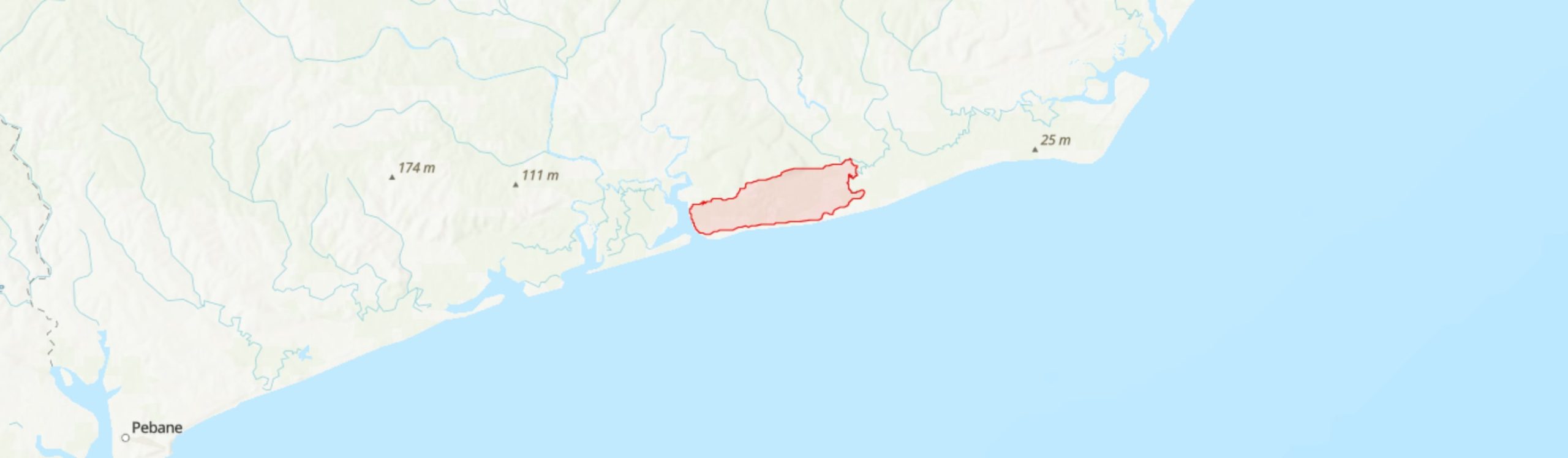
Central co-ordinates: 17.0451 S, 38.75080 E
Area: 71km²
Qualifying IPA Criteria
A(i)Site contains one or more globally threatened species, C(iii)Site contains nationally threatened or restricted habitat or vegetation types, AND/OR habitats that have severely declined in extent nationally
IPA assessment rationale
Moebase qualifies as an Important Plant Area under criterion A(i) as it is the only known extant site for Triceratella drummondii (CR), and holds a globally important population of Icuria dunensis (EN). It is also deemed to contain over 5% of the global population of Warneckea sessilicarpa (CR) which is known from only four sites, one of which may no longer be extant - Moebase is likely to be a critical site for the survival of this species. It also qualifies under criterion C(iii) as the Icuria-dominated coastal dry forest of the Rovuma Centre of Endemism is a nationally threatened and range-restricted habitat, and the Moebase IPA contains the largest known example of this forest type.
Site description
The Moebase IPA is located in Pebane District of Zambézia Province. It lies immediately south of the coastal village of Moebase, ca. 215 km ENE of the seaport of Quelimane. The site falls within the southern extension of the proposed Rovuma Centre of Plant Endemism [CoE] (Burrows & Timberlake 2011; Darbyshire et al. 2019a) and comprises a small area of dune systems with coastal dry forest patches and interdunal slacks on heavy mineral-rich coastal sands.
Botanical significance
This site is of high botanical importance for the presence of three rare and threatened species of the Rovuma CoE. Firstly, it is the southern-most locality for the globally Endangered endemic tree Icuria dunensis (‘icuri’ or ‘ncuri’). The Moebase IPA holds the largest confirmed patches of Icuria-dominated forest, totalling ca. 9 km2, and it is one of only three Icuria forests assessed to be in “very good condition” using a Forest Ecological Condition Index (A. Massingue, unpubl. data). This is also the first site at which Icuria was recognised as a distinct forest tree during surveys in August 1995 (Lubke et al. 2018). Secondly, the seasonal wetlands in the dune slacks at Moebase hold the only known extant population of the diminutive wetland herb Triceratella drummondii, which is assessed as Critically Endangered (S. Richards, in press). This species was previously known also from the Gwanda area of Zimbabwe, over 1,000 km inland from Moebase, but it has not been observed at that locality since the 1960s despite three searches undertaken between 1996 and 2001 to no avail (Barker et al. 2001). Around twenty individuals were observed within a single population was observed during an Environmental Impact Assessment at Moebase in 1997 (Barker et al. 2001). Finally, evidence has recently come to light that the Critically Endangered endemic shrub Warneckea sessilicarpa occurs within the Icuria forests - this is derived from a specimen (Boana #154) collected in 1997 which had previously been misidentified as W. sousae but is confirmed to be W. sessilicarpa by the global expert on this group, R.D. Stone (pers. comm.). Further discoveries of rare species are likely to be made with further exploration of these forest patches.
Habitat and geology
The Icuria forest is highly impressive here, forming dense, mono-dominant dry forest stands with many mature individuals, some reaching up to 40 m in height (A. Msssingue, pers. obs.), and with substantial recruitment evident. These forests occur on low-lying, seasonally damp, ancient sand dune systems behind the foredunes, between 1 km and 4 km from the shoreline (Lubke et al. 2018). The sands of these dunes are rich in heavy minerals including ilmenite (titanium ore), which may be of interest for mining (URS/Scott Wilson 2011). Icuria patches are surrounded by open dune scrub and woodland with typical species including Garcinia livingstonei and Strychnos spinosa (Barker et al. 2001). The interdunal slacks have a high water table and include areas of free-standing water in the wet season. Dominant species recorded in these wetlands include Eragrostis ciliaris, Xyris anceps and Utricularia sp.; Triceretalla drummondii was found in these slacks growing on open wet sands together with the Digitaria eriantha and Bulbostylis hispidula (Barker et al. 2001).
Extensive areas of miombo woodland were previously found on the raised, freely drained decksand deposits to the east of the village and north of the Icuria patches, but this woodland has been seriously depleted in recent decades as the village and associated subsistence agriculture has expanded - these miombo woodlands are excluded from the IPA delineation. To the west, the Moebase Estuary has extensive stands of mangroves, and there are also mangroves along the eastern boundary.
A habitat survey was conducted as part of an initial Environmental Impact Assessment conducted on the Moebase mining exploration concession (see Conservation Issues) but a full species inventory would be desirable and may well uncover further rare and threatened species.
The climate at Moebase is highly seasonal, with rainfall peaking in December to March; the average annual precipitation is approximately 1350 mm.
Conservation issues
This IPA falls within the extensive (>8,000 km2) Primeiras & Segundas Environmental Protection Area (APAIPS) which extends along the coast south to Pebane and north to Angoche. However, the emphasis here is on offshore and marine protection, and there is little evidence of conservation action at Moebase at present.
The surrounding area is subject to high population pressure from the expanding settlement of Moebase and encroachment of subsistence agriculture into natural habitats. A previously large area of miombo woodland on the eastern edge of the village has been largely destroyed over the past 30 – 40 years and it is feared that, now that this wood resource has been largely exhausted, the local population may target the Icuria patches more frequently (Darbyshire et al. 2019b). However, at present the Icuria patches are largely intact. The primary threats currently are clearance for access routes to the beach, uncontrolled burning, and the stripping of Icuria bark for making ropes (A. Massingue, pers. obs.). Areas of fixed dunes in both the west and east of the IPA have been converted to mashambas.
A significant future threat to this IPA is that it falls within a mining concession (License 4623C, Moebase and Naburi deposits, currently owned by Pathfinder Minerals plc), and has commercially viable concentrations of heavy minerals (URS/Scott Wilson 2011). There is continued interest in the exploitation of these deposits.
The Moebase IPA overlaps with the Moebase Region Important Bird Area (BirdLife International 2020) which covers the Moebase Estuary and surrounding coastal habitats. The area is also of interest for other faunal groups including reptiles. This site is included within the extensive APAIPS Key Biodiversity Area. As Moebase is the only known extant locality for the Critically Endangered species, Triceratella drummondii, it would also qualify as an Alliance for Zero Extinction site.
Ecosystem services
This IPA is considered to provide a range of ecosystem services. The stands of Icuria in particular help to stabilise and protect the coastal sand deposits and so prevent excessive erosion during extreme weather events. The forest also provides provisioning services for the local community, which could be managed at sustainable levels. It also provides important habitat and supporting services for a range of fauna.
Site assessor(s)
Iain Darbyshire, Royal Botanic Gardens, Kew
Alice Massingue, Universidade Eduardo Mondlane
IPA criterion A species
| Species | Qualifying sub-criterion | ≥ 1% of global population | ≥ 5% of national population | 1 of 5 best sites nationally | Entire global population | Socio-economically important | Abundance at site |
|---|---|---|---|---|---|---|---|
| Icuria dunensis Wieringa | A(i) |  |
|
|
 |
|
Abundant |
| Warneckea sessilicarpa (A.Fern. & R.Fern.) Jacq.-Fel. | A(i) | |
|
|
|
|
Unknown |
| Triceratella drummondii Brenan | A(i) | |
|
|
|
|
Scarce |
Icuria dunensis Wieringa
Qualifying sub-criterion:
A(i)
≥ 1% of global population:
≥ 5% of national population:
1 of 5 best sites nationally:
Entire global population:
Socio-economically important:
Abundance at site:
Abundant
Warneckea sessilicarpa (A.Fern. & R.Fern.) Jacq.-Fel.
Qualifying sub-criterion:
A(i)
≥ 1% of global population:
≥ 5% of national population:
1 of 5 best sites nationally:
Entire global population:
Socio-economically important:
Abundance at site:
Unknown
Triceratella drummondii Brenan
Qualifying sub-criterion:
A(i)
≥ 1% of global population:
≥ 5% of national population:
1 of 5 best sites nationally:
Entire global population:
Socio-economically important:
Abundance at site:
Scarce
IPA criterion C qualifying habitats
| Habitat | Qualifying sub-criterion | ≥ 5% of national resource | ≥ 10% of national resource | 1 of 5 best sites nationally | Areal coverage at site |
|---|---|---|---|---|---|
| Rovuma Icuria Coastal Dry Forest | C(iii) | |
|
|
8.95 |
Rovuma Icuria Coastal Dry Forest
Qualifying sub-criterion:
C(iii)
≥ 5% of national resource:
≥ 10% of national resource:
Areal coverage at site:
8.95
General site habitats
| General site habitat | Percent coverage | Importance |
|---|---|---|
| Forest - Subtropical/Tropical Dry Forest | |
Major |
| Shrubland - Subtropical/Tropical Dry Shrubland | |
Major |
| Marine Coastal/Supratidal - Coastal Sand Dunes | |
Major |
| Savanna - Moist Savanna | |
Minor |
| Artificial - Terrestrial - Arable Land | |
Minor |
Forest - Subtropical/Tropical Dry Forest
Percent coverage:
Importance:
Major
Shrubland - Subtropical/Tropical Dry Shrubland
Percent coverage:
Importance:
Major
Marine Coastal/Supratidal - Coastal Sand Dunes
Percent coverage:
Importance:
Major
Savanna - Moist Savanna
Percent coverage:
Importance:
Minor
Artificial - Terrestrial - Arable Land
Percent coverage:
Importance:
Minor
Land use types
| Land use type | Percent coverage | Importance |
|---|---|---|
| Tourism / Recreation | |
Major |
| Harvesting of wild resources | |
Unknown |
| Agriculture (arable) | |
Minor |
Tourism / Recreation
Percent coverage:
Importance:
Major
Harvesting of wild resources
Percent coverage:
Importance:
Unknown
Agriculture (arable)
Percent coverage:
Importance:
Minor
Threats
| Threat | Severity | Timing |
|---|---|---|
| Agriculture & aquaculture - Annual & perennial non-timber crops - Small-holder farming | Medium | Ongoing - trend unknown |
| Biological resource use - Gathering terrestrial plants | Medium | Ongoing - increasing |
| Energy production & mining - Mining & quarrying | Unknown | Future - inferred threat |
Agriculture & aquaculture - Annual & perennial non-timber crops - Small-holder farming
Severity:
Medium
Timing:
Ongoing - trend unknown
Biological resource use - Gathering terrestrial plants
Severity:
Medium
Timing:
Ongoing - increasing
Energy production & mining - Mining & quarrying
Severity:
Unknown
Timing:
Future - inferred threat
Protected areas
| Protected area name | Protected area type | Relationship with IPA | Areal overlap |
|---|---|---|---|
| Primeiras & Segundas | Environmental Protection Area | protected/conservation area encompasses IPA | |
Primeiras & Segundas
Protected area type:
Environmental Protection Area
Relationship with IPA:
protected/conservation area encompasses IPA
Areal overlap:
Conservation designation
| Designation name | Protected area | Relationship with IPA | Areal overlap |
|---|---|---|---|
| Moebase Region | Important Bird Area | protected/conservation area overlaps with IPA | |
| APAIPS | Key Biodiversity Area | protected/conservation area encompasses IPA | |
Moebase Region
Protected area:
Important Bird Area
Relationship with IPA:
protected/conservation area overlaps with IPA
Areal overlap:
APAIPS
Protected area:
Key Biodiversity Area
Relationship with IPA:
protected/conservation area encompasses IPA
Areal overlap:
Management type
| Management type | Description | Year started | Year finished |
|---|---|---|---|
| No management plan in place | |
|
No management plan in place
Year started:
Year finished:
Bibliography
Icuria dunensis. The IUCN Red List of Threatened Species 2019: e.T136532836A136538183.
The IUCN Red List of Threatened Species Available online
The endemic plants of Mozambique: diversity and conservation status
PhytoKeys, Vol 136, page(s) 45-96 Available online
Mozambique’s centres of endemism, with special reference to the Rovuma Centre of Endemism of NE Mozambique and SE Tanzania.
South African Journal of Botany, Vol 77, page(s) 518
Important Bird Areas factsheet: Primeiras and Segundas Environmental Protection Area (APAIPS).
Scoping Study Report on the Moebase and Naburi Mineral Sands Deposits, Mozambique. Report prepared for Pathfinder Minerals plc.
A new species of tree, Icuria dunensis (Icurri), of undescribed coastal forests in north-eastern Mozambique.
South African Journal of Botany, Vol 115, page(s) 292-293 Available online
Rediscovery of Triceratella drummondii, and comments on its relationships and position within the family.
Bothalia, Vol 31, page(s) 37-39
Triceratella drummondii. The IUCN Red List of Threatened Species.


Recommended citation
Iain Darbyshire, Alice Massingue (2024) Tropical Important Plant Areas Explorer: Moebase (Mozambique). https://tipas.kew.org/site/moebase-2/ (Accessed on 27/07/2024)