Country: Ethiopia
Administrative region: Oromia (Regional State)
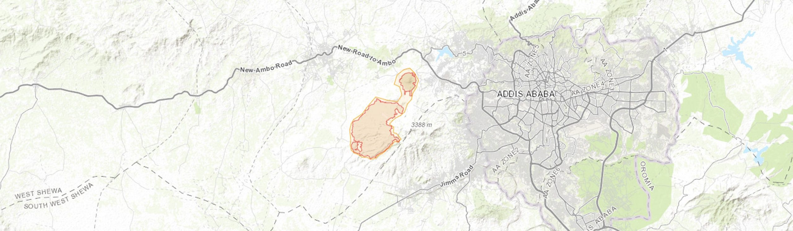
Central co-ordinates: 8.97720 N, 38.55015 E
Area: 35km²
Qualifying IPA Criteria
A(i)Site contains one or more globally threatened species, C(iii)Site contains nationally threatened or restricted habitat or vegetation types, AND/OR habitats that have severely declined in extent nationally
IPA assessment rationale
Menagesha-Suba Forest is an important remnant of the nationally threatened Dry Afromontane Forest, therefore qualifying as an IPA under criterion C(iii). It also qualifies under criterion A(i) due to the presence of the globally threatened species, Chrysojasminum stans (VU), Gymnosporia addat (VU) and Hyparrhenia tuberculata (VU). The site is threatened from unsustainable use and conversion of forest to agricultural land.
Also of note is the presence of the widespread but globally threatened timber species Prunus africana (VU), and the economically important timber species, Juniperus procera (LC, decreasing). These do not trigger IPA status but could in the future.
Site description
Menagesha-Suba Forest is situated approximately 20-30 km southwest of Addis Ababa, within the West Shewa Zone of Oromia Regional State. It lies within the Shewa floristic region, on the central Ethiopian Plateau. The Menagesha-Suba Forest is one of the few remaining extensive examples of the nationally threatened Dry Afromontane Forest in Ethiopia. The forest name derives from the nearby town and village, Menagesha and Suba respectively.
The IPA is comprised of two disjunct forest blocks; the smaller Menagesha Forest in the northeast of the IPA (399 ha) situated on a small volcanic cone, and the larger Suba Forest in the southwest of the IPA (3,096 ha) lying on the southern slope of Mount Wechacha, an extinct volcano (Sebsebe, 1988; Tekalign, 2019). These two mountainous regions are surrounded by low-lying plains that have been intensively farmed for centuries.
Menagesha-Suba Forest is thought to be the oldest preserved forest in Ethiopia (Tekalign, 2019). The original Juniperus forest was largely degraded from over-exploitation until the 15th century when Emperor Zera Yakob ordered the replanting of Menagesha-Suba Forest using seeds of Juniperus procera Hochst. ex Endl. from Wof-Washa Forest (Sebsebe, 1988).
Menagesha-Suba Forest is designated as a National Forest priority Area (NFPA), Important Bird Area (IBA), and Key Biodiversity Area (KBA).
Botanical significance
Dry Afromontane Forests once covered an extensive area of the Ethiopian Highlands but have been reduced to remnant fragments. Menagesha-Suba Forest is one of the best and most extensive remaining examples of this nationally threatened habitat on the central Ethiopian plateau.
Menagesha-Suba Forest is a key locality for three globally threatened, Ethiopian Highlands endemic species: Chrysojasminum stans (VU), Gymnosporia addat Loes. (formerly Maytenus addat; VU) and Hyparrhenia tuberculata Clayton (VU). Additionally, there has been a recent record of the endemic tree, Acacia negrii Pic.Serm. (currently NT, but a priority for reassessment as it is likely to be globally threatened). Tilahun et al. (2011) recorded 16 endemic species in the smaller Menagesha forest alone.
Two globally threatened species, Carex monostachya A.Rich. (VU) and the Ethiopian endemic Indigofera rothii Baker (EN), were recorded in the KBA assessment, however this appears to be incorrect. [requires further investigation]
Also of note is the widespread but globally threatened medicinal timber species, Prunus africana (Hook.f.) Kalkman (VU), present within the forest. However, this IPA is not thought to be a globally important site for this widespread species. Juniperus procera (LC, but decreasing globally) is the dominant species within the forest and a highly economically important tree species in Ethiopia.
Habitat and geology
Menagesha-Suba Forest is one of the few remnant Dry Afromontane Forests in Ethiopia, dominated by Juniperus procera and Olea europea subsp. cuspidata (Wall. & G.Don) Cif. (Sebsebe, 1988). It is floristically similar to the nearby Chilimo Forest IPA (Bekele, 1993).
The topology of Menagesha-Suba Forest is characterised by rolling hills and mountainous terrain of the extinct volcanic cone of Mount Wechecha and nearby smaller volcanic cone, dissected by rivers and streams (Sebsebe, 1988; Tekalign, 2019). The surrounding areas are characterised by plains comprised of an intensive agricultural mosaic including agroforestry, cropland, and rangeland. Rock types within the IPA and surrounding area vary from white, coarsely porphyritic trachyte to green, often porphyritic trachyte (Sebsebe, 1988). The volcanic bedrock on which the IPA lies is thought to date back to the upper Pliocene (Eshetu et al., 2004). Soils are predominantly chromic luvisols (reddish clay-sand), derived from the trachyte rocks (Sebsebe, 1988; Eshetu & Högberg, 2000). Nitisols have also been reported (Eshetu et al., 2004; Jones et al., 2013). Soil pH has been found to range from 5.2 to 7.3 (Wubet et al., 2003).
The forest has its lower boundary at 2255 m and upper limit at 3075 m. Higher elevations of the forest are occupied by Juniperus procera, Hagenia abyssinica (Bruce) J.F.Gmel, Olea europea subsp. cuspidata, Erica arborea L., and smaller trees and shrubs such as Myrsine melanophloeos (L.) R.Br. ex Sweet and Rosa abyssinica R.Br. ex Lindl. (Tilahun et al., 2015; Tekalign, 2019). Afrocarpus gracilior (Pilg.) C.N.Page (Podocarpus gracilior) dominates at lower elevations and in sheltered valleys (Sebsebe, 1988). Prunus africana is scattered throughout the forest (Tekalign, 2019). Overall, the four most dominant species within the forest are Juniperus procera, Afrocarpus gracilior, Olea europaea subsp. cuspidata, and Olinia rochetiana A.Juss. (Sebsebe, 1988; Bekele, 1993). Sebsebe (1988) recorded 29 shrub, 14 tree, 16 herb, 11 fern, 10 liana, five epiphyte, three sedge, and two grass species. A recent floristic survey of the Menagesha component of the Menagesha-Suba Forest reported over 200 species representing 182 genera and 76 families, with Asteraceae being the most diverse family (Tilahun et al., 2011).
The IPA also contains plantations of exotic species, namely Cupressus lusitanica Mill., Eucalyptus camaldulensis Dehnh., Eucalyptus globulus Labill., Pinus radiata D.Don, and Pinus patula Schiede ex Schltdl. & Cham., and plantations of the indigenous Juniperus procera (Sebsebe, 1988; Tekalign, 2019).
The climate of Menagesha-Suba Forest is classified as tropical alpine (Tekalign, 2019). Rainfall is bimodal with a long wet season running from mid-June to September, and a short wet season from April to May (Eshetu et al., 2004; Duguma et al., 2009). The mean annual rainfall ranges from 1,017 mm to 1,225 mm (Teketay, 1997; Eshetu et al., 2004). Mean annual temperatures range from 11°C to 22°C (Bekele, 1996). Daily temperatures as low as 2.4°C have been recorded in Holeta town (Bekele, 1993).
Conservation issues
Menagesha-Suba Forest has been heavily degraded and exploited for the last five centuries (Sebsebe, 1988). Shortage of land for agriculture, poor land productivity, and lack of other forested areas have led to the overexploitation of the site (Duguma et al., 2009; Duguma et al., 2019). Duguma et al. (2009) reported that 1000 m3 of charcoal derived from the forest is sold at local markets annually. Increasing populations have caused a rising demand for forest products; settlements in the neighbouring Holetta watershed are thought to have increased from 4,752 ha to 10,563 ha between 1984 and 2006 (Feyissa et al., 2014). Another factor affecting Menagesha-Suba Forest is resource governance issues; forest policies implemented by the last three administrations have been drivers in both forest cover gain and loss (Duguma et al., 2019; Tekalign, 2019), and governance over the forest has led to conflicts between local communities and the forest administrations (Tekalign et al., 2018).
In the late 1930s forest cover was thought to be less than 1,000 ha, but by the 1960s it was thought to have increased to ca. 3,000-3,500 ha. This was followed by a period of decline and by 1988 the forest extent had fallen to 2,720 ha, before increasing again to 3,590 ha by 1998 (Sebsebe, 1988; Duguma et al., 2009; Duguma et al., 2019; Tekalign, 2019). The current estimate is ca. 3,495 ha, of which 2,350 ha comprises of indigenous forest and 1,150 ha of plantation forest (Tekalign, 2019). Satellite imagery taken between 1984 and 2019 shows that the forest has increased in some areas and decreased in others, often with patches inside the forest being cleared (Google Earth, 2021). Deforestation from the middle of the forest area is likely from plantation cutting for income (Tekalign, 2019).
Menagesha-Suba Forest is thought to be the oldest state forest in Ethiopia. In ancient times the original Juniperus forest had been devastated due to agricultural conversion to support the growing populations from Addis Ababa, Menagesha, Holeta, and Sebetta (Eshetu et al., 2004). This is supported by evidence from soil analysis which suggests long periods of cultivation or grassland were present before the current forest (Eshetu & Högberg, 2000). In the 15th century, Emperor Zera Yakob ordered the reforestation of the Menagesha area using Juniperus procera seeds sourced from Wof-Washa forest northeast of Addis Ababa, and declared Menagesha-Suba as a crown forest (Sebsebe, 1988; Eshetu & Högberg, 2000). This is supported by the findings of Sertse et al. (2011), which showed that the Juniperus procera populations of Menagesha-Suba and Wof-Washa are not significantly different genetically.
The first forest regulation was introduced by Emperor Menelik II in 1888 by royal decree; he employed guards to protect the forest and banned the cutting of trees without prior permission (Sebsebe, 1988). During Emperor Menelik’s reign, exotic Eucalyptus spp. were introduced as a fast growing source of fuelwood and construction material (Tekalign, 2019).
In 1900, forest utilization was granted to a German industrialist who established a sawmill within the forest, resulting in a large decline of forest cover (Sebsebe, 1988). An estimated 150-200 m3 of timber was exported monthly from the Menagesha sawmill (Logan, 1946, in Bekele, 1993). During the Italian occupation (1936-1941), over 1,000 ha of mainly Juniperus procera was cut down and a railway was constructed to facilitate timber export (Tekalign, 2019). In 1949, Emperor Haile Selassie ordered the establishment of a tree nursery, and suspended the operation of the sawmill in the mid 1950s (Tekalign, 2019). In 1956, the Ministry of Agriculture initiated a reforestation programme of Menagesha-Suba Forest (Sebsebe, 1988). During the Derg regime, the forest became strictly protected under the 1975 land reform (Tekalign, 2019). Menagesha-Suba Forest was designated as a National Forest Priority Area (NFPA) in 1981.
Menagesha-Suba Forest was first delineated in 1984. An area of 9,557 ha was designated as state forest; this included conversion of agricultural land belonging to the local communities into state-owned plantations (Sebsebe, 1988; Tekalign, 2019). These plantations were created not only to increase forest cover and a sustainable source of timber but to create a buffer between the indigenous forest and local communities (Duguma et al., 2009; Tekalign, 2019). Under this regime, forest cover increased but there was little regard for the local community, and hundreds of people were displaced (Duguma et al., 2019). Use of the forest was restricted, with the exception of minor fuelwood collection. These rules were reinforced by the law, resulting in intense conflicts and court proceedings (Duguma et al., 2019).
When the Derg regime ended in 1991, local communities started to utilize the forest unsustainably, resulting in a reduction of forest cover. In 2007 the Menagesha-Suba NFPA was transferred to the administration of Oromia Forest and Wildlife Enterprise (Tekalign, 2019). In 2009, despite the presence of a forest management office and guards, illegal logging of trees including Cupressus lusitanica and Juniperus procera was evident (Duguma et al., 2009). Tekalign (2019) reports that participatory forest management (PFM) was attempted between 2011 and 2013, supported by Gesellschaft für Internationale Zusammenarbeit (GIZ), but failed due to disagreements between beneficiaries and the PFM.
In 2015, a ten year project known as the Oromia Forested Landscape Programme (OFLP) started. The project is one of the national REDD+ pilots in Africa, aiming to reduce net greenhouse gas emissions from forest cover change and to improve the enabling environment for sustainable forest management and investment in Oromia Regional State (OFLP, 2017). The project encompasses all forests in the Oromia Regional State, however the direct implications for Menagesha-Suba Forest is unknown.
Deforestation and the topology of the area make Menagesha-Suba Forest prone to erosion. In some areas the soils have been reduced and bare rock exposed (Sebsebe, 1988).
The IPA is encompassed by the Menagesha-Suba NFPA, Menagesha-Suba State Forest Important Bird Area (IBA), and Menagesha-Suba State Forest Key Biodiversity Area (KBA). The IBA was designated in 1996 under criterion A3 based on the occurrence of 27 threatened bird species; however, these are now all classified as Least Concern (LC) under the IUCN Red List (BirdLife, 2021). In 2001, the forest was designated as a KBA; triggered by the presence of Carex monostachya (VU) and Indigofera rothii (then VU, now EN) (Key Biodiversity Areas, 2020). However, the records of these species at this site are likely to be erroneous, though further investigation is needed.
Ecosystem services
The forest is a source of valuable products such as timber and poles, and non-timber products such as animal feed and wild edible plants (Duguma et al., 2009). The forest is also highly valued as a water catchment, and source of medicinal plants, such as Prunus africana. The forest vegetation also helps prevent soil erosion. Due to restrictions on the forest use, local communities surrounding the forest largely rely on agriculture as their main source of income; agricultural crops include teff, wheat, and beans (Duguma et al., 2009). However, Menagesha-Suba is the only nearby forest and therefore illegal use continues as many rely on the products it provides (Tekalign, 2019).
Menagesha-Suba Forest is a tourist location for bird watching, game viewing, hiking and forest walks. The Oromia Forest and Wildlife Enterprise (2021) note a decade long history of tourism with over 10,000 tourists annually. Currently the forest contains five hiking trails, an exhibition centre, guesthouses and four campsites (Tekalign et al., 2018; Oromia Forest and Wildlife Enterprise, 2021). As of 2018, local communities were not involved with tourism in the forest, and all income generated went to the Government (Tekalign et al., 2018). This leaves significant potential for tourism expansion involving the local communities and cultural tourism. Tekalign (2019) suggested that tourism in Menagesha-Suba Forest is in the initial stages and that historical features such as the abandoned sawmill from 1900 and old railway could be exploited as tourist attractions, along with the improvement of visitor facilities and local involvement. Recently the Ethiopian Government has made plans to establish a baseline for proposed eco-tourism within the site (Ermias Lulekal pers. comm.).
The IPA also contains places of spiritual importance including the Menagesha Medhane Alem and Menagesha Amba Mariam (St. Mary) historical monasteries within the smaller Menagesha forest.
Fauna that have been recorded within the IPA include the Caracal (Caracal caracal), Leopard (Panthera pardus, VU), Bushpig (Potamochoerus larvatus), Abyssinian Hare (Lepus habessinicus), Aardvark (Orycteropus afer), Anubis Baboon (Papio anubis), Black-and-White Colobus Monkey (Colobus guereza), and the Ethiopian endemic Menelik’s Bushbuck (Tragelaphus scriptus subsp. meneliki) (Bekele, 1996; Tekalign, 2019). Menagesha Forest is known to contain over 108 bird species, including the Ethiopian endemics/near-endemics Abyssinian Woodpecker (Dendropicos abyssinicus), Abyssinian Catbird (Parophasma galinieri), Black-winger Lovebird (Agapornis taranta), and Yellow Fronted Parrot (Poicephalus flavifrons) (Bekele, 1996; Tekalign, 2019). At least 12 rodent species are known to occur within the forest, including the Ethiopian endemics Gray-tailed Narrow-headed Rat (Stenocephalemys griseicauda) and Praomys albipes (Bekele, 1996).
Site assessor(s)
Assessed by:
Eden House, Royal Botanic Gardens, Kew
Iain Darbyshire, Royal Botanic Gardens, Kew
Ermias Lulekal, Addis Ababa University
Sebsebe Demissew, Addis Ababa University
Sileshi Nemomissa, Addis Ababa University
Tesfaye Awas, Ethiopian Biodiversity Institute
Birhanu Belay Telake, Gullele Botanic Garden
IPA criterion A species
| Species | Qualifying sub-criterion | ≥ 1% of global population | ≥ 5% of national population | 1 of 5 best sites nationally | Entire global population | Socio-economically important | Abundance at site |
|---|---|---|---|---|---|---|---|
| Gymnosporia addat Loes. | A(i) |  |
|
|
 |
|
|
| Prunus africana (Hook.f.) Kalkman | A(i) | |
|
|
|
|
|
| Chrysojasminum stans (Pax) Banfi | A(i) | |
|
|
|
|
|
| Hyparrhenia tuberculata Clayton | A(i) | |
|
|
|
|
Gymnosporia addat Loes.
Qualifying sub-criterion:
A(i)
≥ 1% of global population:
≥ 5% of national population:
1 of 5 best sites nationally:
Entire global population:
Socio-economically important:
Abundance at site:
Prunus africana (Hook.f.) Kalkman
Qualifying sub-criterion:
A(i)
≥ 1% of global population:
≥ 5% of national population:
1 of 5 best sites nationally:
Entire global population:
Socio-economically important:
Abundance at site:
Chrysojasminum stans (Pax) Banfi
Qualifying sub-criterion:
A(i)
≥ 1% of global population:
≥ 5% of national population:
1 of 5 best sites nationally:
Entire global population:
Socio-economically important:
Abundance at site:
Hyparrhenia tuberculata Clayton
Qualifying sub-criterion:
A(i)
≥ 1% of global population:
≥ 5% of national population:
1 of 5 best sites nationally:
Entire global population:
Socio-economically important:
Abundance at site:
IPA criterion C qualifying habitats
| Habitat | Qualifying sub-criterion | ≥ 5% of national resource | ≥ 10% of national resource | 1 of 5 best sites nationally | Areal coverage at site |
|---|---|---|---|---|---|
| Dry Afromontane Forest | C(iii) | |
|
|
2350 |
Dry Afromontane Forest
Qualifying sub-criterion:
C(iii)
≥ 5% of national resource:
≥ 10% of national resource:
Areal coverage at site:
2350
General site habitats
| General site habitat | Percent coverage | Importance |
|---|---|---|
| Forest - Subtropical/Tropical Moist Montane Forest | |
Major |
| Rocky Areas | |
Minor |
| Artificial - Terrestrial - Plantations | |
Major |
Forest - Subtropical/Tropical Moist Montane Forest
Percent coverage:
Importance:
Major
Rocky Areas
Percent coverage:
Importance:
Minor
Artificial - Terrestrial - Plantations
Percent coverage:
Importance:
Major
Land use types
| Land use type | Percent coverage | Importance |
|---|---|---|
| Forestry | |
Major |
| Harvesting of wild resources | |
Minor |
| Tourism / Recreation | |
Major |
Forestry
Percent coverage:
Importance:
Major
Harvesting of wild resources
Percent coverage:
Importance:
Minor
Tourism / Recreation
Percent coverage:
Importance:
Major
Threats
| Threat | Severity | Timing |
|---|---|---|
| Agriculture & aquaculture - Wood & pulp plantations - Agro-industry plantations | High | Past, not likely to return |
| Biological resource use - Logging & wood harvesting - Intentional use: large scale (species being assessed is the target) [harvest] | High | Ongoing - trend unknown |
| Biological resource use - Logging & wood harvesting | High | Ongoing - trend unknown |
Agriculture & aquaculture - Wood & pulp plantations - Agro-industry plantations
Severity:
High
Timing:
Past, not likely to return
Biological resource use - Logging & wood harvesting - Intentional use: large scale (species being assessed is the target) [harvest]
Severity:
High
Timing:
Ongoing - trend unknown
Biological resource use - Logging & wood harvesting
Severity:
High
Timing:
Ongoing - trend unknown
Protected areas
| Protected area name | Protected area type | Relationship with IPA | Areal overlap |
|---|---|---|---|
| Menagesha-Suba | National Forest Priority Area | protected/conservation area overlaps with IPA | |
Menagesha-Suba
Protected area type:
National Forest Priority Area
Relationship with IPA:
protected/conservation area overlaps with IPA
Areal overlap:
Conservation designation
| Designation name | Protected area | Relationship with IPA | Areal overlap |
|---|---|---|---|
| Menagesha-Suba State Forest IBA | Important Bird Area | protected/conservation area overlaps with IPA | |
| Menagesha-Suba State Forest KBA | Key Biodiversity Area | protected/conservation area overlaps with IPA | |
Menagesha-Suba State Forest IBA
Protected area:
Important Bird Area
Relationship with IPA:
protected/conservation area overlaps with IPA
Areal overlap:
Menagesha-Suba State Forest KBA
Protected area:
Key Biodiversity Area
Relationship with IPA:
protected/conservation area overlaps with IPA
Areal overlap:
Management type
| Management type | Description | Year started | Year finished |
|---|---|---|---|
| Site management plan in place | In 2007 the forest was transferred to the Oromia Forest and Wildlife Enterprise; management largely seems to focus on plantation management, guarding the forest from exploitation, and tourism. Specifics on their management are unknown. | 2007 | |
Site management plan in place
In 2007 the forest was transferred to the Oromia Forest and Wildlife Enterprise; management largely seems to focus on plantation management, guarding the forest from exploitation, and tourism. Specifics on their management are unknown.
Year started:
2007
Year finished:
Bibliography
Google Earth
Satellite Imagery Available online
Soil Atlas of Africa
Vegetation ecology of remnant Afromontane forests on the Central Plateau of Shewa, Ethiopia.
Acta Phytogeographica Suecica, Vol 79, page(s) 1-61
Rodents of the Menagesha State Forest, Ethiopia with an emphasis on the endemic Praomys albipes Ruppel 1842.
Tropical Zoology, Vol 9(1), page(s) 201-212
Menagesha State Forest Important Bird Area (IBA).
The floristic composition of the Menagesha State Forest and the need to conserve such forests in Ethiopia.
Mountain Research and Development, Vol 8(2/3), page(s) 243-247
The community-state forest interaction in Menagesha Suba area, Ethiopia: The challenges and possible solutions.
Forests, Trees and Livelihoods, Vol 19, page(s) 111-128
Deforestation and Forest Degradation as an Environmental Behavior: Unpacking Realities Shaping Community Actions.
Land, Vol 8, page(s) 26
Reconstruction of Forest Site History in Ethiopian Highlands Based on 13C Natural Abundance of Soils.
Ambio, Vol 29(2), page(s) 83-89
Historical land use patterns affects the chemistry of forest soils in the Ethiopian highlands.
Geoderma, Vol 118, page(s) 149-165
Assessment of Habitat Changes in Holeta Watershed, Central Oromiya, Ethiopia.
International Journal of Earth Sciences and Engineering, Vol 7(4), page(s) 1370-1375
Menagesha Sate Forest Key Biodiversity Area (KBA).
Oromia National Regional State Forested Landscape Program (Project ID P156475). Project Implementation Manual: Final Draft (2017-2022).
Suba Menagesha Forest.
Anthropogenic and natural causes influencing population genetic structure of Juniperus procera Hochst. ex Endl. in the Ethiopian highlands.
Genetic Resources and Crop Evolution, Vol 58, page(s) 849-859
Seedling populations and regeneration of woody species in dry Afromontane forests of Ethiopia.
Forest Ecology and Management, Vol 98, page(s) 149-165
Forest ecosystem services and resilience of the social-ecological system in a protected forest of the central highlands of Ethiopia. PhD Thesis.
Do Tourists’ Preferences Match the Host Community’s Initiatives? A Study of Sustainable Tourism in One of Africa’s Oldest Conservation Areas.
Sustainability, Vol 10, page(s) 4167
Structure and Regeneration Status of Menagesha Amba Mariam Forest (Egdu Forest) in Central Highlands of Shewa, Ethiopia.
Advances in Life Science and Technology, Vol 34, page(s) 60-80
Mycorrhizal status of indigenous trees in dry Afromontane forests of Ethiopia.
Forest Ecology and Management, Vol 179, page(s) 387-399
Floristic Composition and Community Analysis of Menagesha Amba Mariam Forest (Egdu Forest) in Central Shewa, Ethiopia.
Ethiopian. J. Biol. Sci., Vol 10(2), page(s) 111-136

Recommended citation
Eden House, Iain Darbyshire, Ermias Lulekal, Sebsebe Demissew, Sileshi Nemomissa, Tesfaye Awas, Birhanu Belay Telake (2025) Tropical Important Plant Areas Explorer: Menagesha-Suba Forest (Ethiopia). https://tipas.kew.org/site/menagesha-suba-forest/ (Accessed on 30/06/2025)