Country: Mozambique
Administrative region: Inhambane (Province)
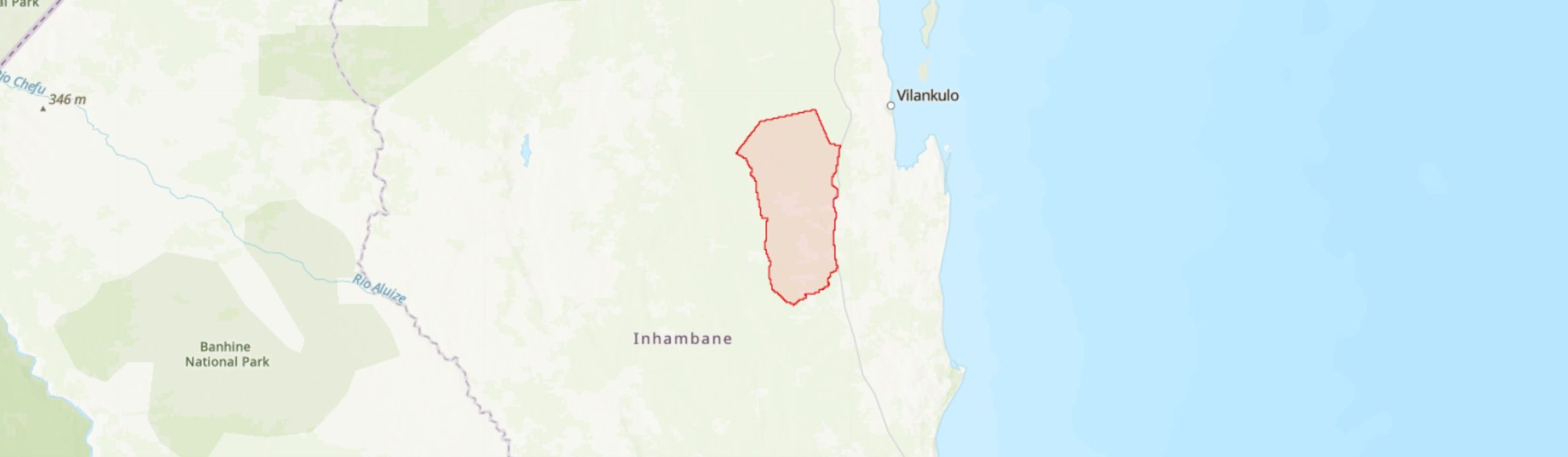
Central co-ordinates: 22.44511 S, 35.05208 E
Area: 2070km²
Qualifying IPA Criteria
A(i)Site contains one or more globally threatened species
IPA assessment rationale
Mapinhane qualifies as an IPA under criterion A(i) in view of the site holding globally important populations of four species of high conservation importance, namely Bauhinia burrowsii (EN), Croton inhambanensis (VU), Ozoroa gomesiana (VU) and Xylia mendoncae (VU).
In total, this IPA supports 14 species that are endemic or near-endemic to Mozambique according to Darbyshire et al. (2019). However, as only eight of these qualify under sub-criterion B(ii), this site does not meet the threshold (3%) of Mozambican species of high conservation importance within the site, but it is possible that further B(ii) species will be uncovered here following more intensive botanical surveys.
Site description
The Mapinhane IPA is shared by Vilanculos and Massinga Districts in northern Inhambane Province. It is situated to the west of the EN1 road, extending beyond Mapinhane village in the north and Chicomo village in the south, and covering an area of 2,070 km2 between the latitudes -22.01° to -22.71° and longitudes 35.72° to 35.33°. The boundaries of this IPA were delineated to encompass important habitats that support a notable number of plant species endemic to Mozambique, including four threatened species, and a range of ecosystems service that the habitats provide. This site is heavily impacted by deforestation due to timber exploitation, subsistence agriculture and settlement expansion, and is further impacted by fire events associated with local communities, resulting in the transformation and degradation of its ecosystems.
Botanical significance
This IPA is of high botanical importance because of the presence, throughout the miombo woodlands and mixed deciduous forests and woodlands, of several endemic and restricted species of the proposed Inhambane (sub-) Centre of Plant Endemism (Darbyshire et al. 2019). Mapinhane holds some of the most extensive populations of four threatened species endemic to northern Inhambane Province: Bauhinia burrowsii (EN), Croton inhambanensis (VU), Ozoroa gomesiana (VU) and Xylia mendoncae (VU), although the latter is rather scarce here.
Overall, this IPA supports eight national endemic plant taxa and six near-endemic plant taxa. The endemic species consist of the four previously mentioned threatened species plus an additional four Least Concern endemics.
Habitat and geology
In the broad sense, the Mapinhane region lies within the Swahilian-Maputaland Regional Transition Zone phytogeographical region according to Clarke (1998), which covers much of central, coastal-belt of Mozambique, and the Southern Zanzibar-Inhambane Coastal Forest Mosaic Ecoregion according to Schipper & Burgess (2015), which stretches for ca. 2,200 km from southern Tanzania to Xai-Xai (Gaza Province) in Mozambique. In a narrower phytogeographical sense, this area constitutes the northern extension of the Maputaland Centre of Endemism, recently proposed as the Inhambane (sub-) Centre of Endemism (Darbyshire et al. 2019).
The climate in the IPA is influenced by the warm current from the Mozambique Channel, and is characterized as tropical dry, with two seasons. The hot and rainy season runs from October to March, while the cool and dry season runs from April to September. Annual rainfall average ranges from 1,000-1,200 mm, whilst temperatures peak in January (28.6°C) and reach a minimum in July (19.0°C) (MAE 2005a, 2005b; MICOA 2012a, 2012b). The geographical elevation of the Mapinhane IPA ranges from 20 – 150 m (Google Earth 2021). A range of soils are present, classified into three groups: (1) sodic soils (mananga soils), (2) sandy soils, and (3) red clay soils (MICOA 2012a, 2012b).
The Environmental Profile Assessment reports by MICOA (2012a, 2012b) for Vilanculos and Massinga Districts respectively provide an overview of the habitat mosaics and plant diversity of the Mapinhane IPA. Two main types of vegetation can be distinguished at this site. (1) Miombo woodlands dominated by Julbernardia globiflora and Brachystegia spiciformis and accompanied by a range of other tree species such as Afzelia quanzensis, Albizia adianthifolia, Garcinia livingstonei, Pterocarpus angolensis and the palm Hyphaene coriacea. (2) Deciduous forests mixed with woodlands also featuring miombo species noted above but with a number of additional taxa including Acacia nigrescens, Balanites maughamii, Cordyla africana, Kirkia acuminata, Sterculia africana, and Suregada zanzibariensis (MICOA 2012a). The grass communities of the IPA are varied, but particularly dominant species include Chloris gayana, C. virgata, Dactyloctenium aegyptium, D. giganteum, Melinis repens and Pogonarthria squarrosa (A. Massingue, pers. comm. 2021).
In addition, as is noted at Temane IPA (approximately 11 km to the north), the miombo woodland and mixed forest-woodland vegetation types of this site are sometimes interspersed with small patches of sand thicket mosaic (Lötter et al. in prep.). More generally, the area covered by Mapinhane IPA encompasses three habitats according to the classification of Lotter et al. (in prep.): mainly Urronga Lowland Dry Woodland and Vilanculos Coastal Miombo with small areas of Pande Sand Thicket.
Conservation issues
The Mapinhane IPA does not lie within a formal protected area. However, the northern portion of the IPA is covered by the recently identified Inhassoro-Vilankulos Key Biodiversity Area (WCS et al. 2021).
This IPA is heavily subject to habitat loss (deforestation) and fragmentation due to timber exploitation, and subsistence agriculture through slash-and-burn methods. The most widley cultivated crops are maize, peanuts, beans and cassava (MAE 2005a, 2005b). Settlement expansion and increased fire frequency through deliberate burning by local communities are further threats (MICOA 2012a, 2012b; A. Massingue. pers. comm. 2021). The MICOA (2012a) report notes that fire events recorded throughout the Mapinhane IPA are also derived from palm wine extraction from Hyphaene coriacea, where fire is used to clear palm leaf thicket and access the sap more easily. Palm wine constitutes one of the main income sources for local households. There is no information available on the threat from invasive plant species on site. However, there are a range of exotic trees planted, such as coconut, citrus fruits, cashew and mango, which occur in small numbers in abandoned areas. All of these above-mentioned activities impact negatively on the IPA through the transformation and degradation of its ecosystems.
Ecosystem services
This IPA of entirely terrestrial habitats contributes significantly to carbon storage and climate regulation, particularly related to the precipitation cycle. Moreover, the forests and woodlands stretching across the IPA also provide a range of provisioning services for the local community, which could be managed at sustainable levels, notably harvesting of firewood, wild fruits, medicinal plants and palm wine extraction from Hyphaene coriacea. These habitats also provide important habitat and supporting services for a range of fauna.
Site assessor(s)
Castigo Datizua, Agricultural Research Institute of Mozambique (IIAM)
Clayton Langa, Agricultural Research Institute of Mozambique (IIAM)
Iain Darbyshire, Royal Botanic Gardens, Kew
Sophie Richards, Royal Botanic Gardens, Kew
IPA criterion A species
| Species | Qualifying sub-criterion | ≥ 1% of global population | ≥ 5% of national population | 1 of 5 best sites nationally | Entire global population | Socio-economically important | Abundance at site |
|---|---|---|---|---|---|---|---|
| Bauhinia burrowsii E.J.D.Schmidt | A(i) |  |
|
|
 |
|
Frequent |
| Croton inhambanensis Radcl.-Sm. | A(i) | |
|
|
|
|
Common |
| Ozoroa gomesiana R.Fern. & A.Fern. | A(i) | |
|
|
|
|
Frequent |
| Xylia mendoncae Torre | A(i) | |
|
|
|
|
Scarce |
Bauhinia burrowsii E.J.D.Schmidt
Qualifying sub-criterion:
A(i)
≥ 1% of global population:
≥ 5% of national population:
1 of 5 best sites nationally:
Entire global population:
Socio-economically important:
Abundance at site:
Frequent
Croton inhambanensis Radcl.-Sm.
Qualifying sub-criterion:
A(i)
≥ 1% of global population:
≥ 5% of national population:
1 of 5 best sites nationally:
Entire global population:
Socio-economically important:
Abundance at site:
Common
Ozoroa gomesiana R.Fern. & A.Fern.
Qualifying sub-criterion:
A(i)
≥ 1% of global population:
≥ 5% of national population:
1 of 5 best sites nationally:
Entire global population:
Socio-economically important:
Abundance at site:
Frequent
Xylia mendoncae Torre
Qualifying sub-criterion:
A(i)
≥ 1% of global population:
≥ 5% of national population:
1 of 5 best sites nationally:
Entire global population:
Socio-economically important:
Abundance at site:
Scarce
General site habitats
| General site habitat | Percent coverage | Importance |
|---|---|---|
| Forest - Subtropical/Tropical Dry Forest | |
Major |
| Shrubland - Subtropical/Tropical Dry Shrubland | |
Major |
| Grassland - Subtropical/Tropical Dry Lowland Grassland | |
Major |
| Artificial - Terrestrial - Arable Land | |
Major |
| Artificial - Terrestrial - Subtropical/Tropical Heavily Degraded Former Forest | |
Major |
| Savanna - Moist Savanna | |
Major |
Forest - Subtropical/Tropical Dry Forest
Percent coverage:
Importance:
Major
Shrubland - Subtropical/Tropical Dry Shrubland
Percent coverage:
Importance:
Major
Grassland - Subtropical/Tropical Dry Lowland Grassland
Percent coverage:
Importance:
Major
Artificial - Terrestrial - Arable Land
Percent coverage:
Importance:
Major
Artificial - Terrestrial - Subtropical/Tropical Heavily Degraded Former Forest
Percent coverage:
Importance:
Major
Savanna - Moist Savanna
Percent coverage:
Importance:
Major
Land use types
| Land use type | Percent coverage | Importance |
|---|---|---|
| Agriculture (arable) | |
Unknown |
| Agriculture (pastoral) | |
Major |
| Forestry | |
Unknown |
| Residential / urban development | |
Major |
| Harvesting of wild resources | |
Major |
Agriculture (arable)
Percent coverage:
Importance:
Unknown
Agriculture (pastoral)
Percent coverage:
Importance:
Major
Forestry
Percent coverage:
Importance:
Unknown
Residential / urban development
Percent coverage:
Importance:
Major
Harvesting of wild resources
Percent coverage:
Importance:
Major
Threats
| Threat | Severity | Timing |
|---|---|---|
| Residential & commercial development - Housing & urban areas | High | Ongoing - increasing |
| Agriculture & aquaculture - Annual & perennial non-timber crops - Shifting agriculture | High | Ongoing - increasing |
| Agriculture & aquaculture - Wood & pulp plantations - Small-holder plantations | Low | Ongoing - trend unknown |
| Agriculture & aquaculture - Livestock farming & ranching - Small-holder grazing, ranching or farming | Medium | Ongoing - trend unknown |
| Transportation & service corridors - Roads & railroads | Medium | Ongoing - trend unknown |
| Biological resource use - Gathering terrestrial plants | High | Ongoing - trend unknown |
| Biological resource use - Logging & wood harvesting | High | Ongoing - increasing |
| Natural system modifications - Fire & fire suppression - Increase in fire frequency/intensity | High | Ongoing - trend unknown |
| Invasive & other problematic species, genes & diseases - Invasive non-native/alien species/diseases | Unknown | Ongoing - trend unknown |
Residential & commercial development - Housing & urban areas
Severity:
High
Timing:
Ongoing - increasing
Agriculture & aquaculture - Annual & perennial non-timber crops - Shifting agriculture
Severity:
High
Timing:
Ongoing - increasing
Agriculture & aquaculture - Wood & pulp plantations - Small-holder plantations
Severity:
Low
Timing:
Ongoing - trend unknown
Agriculture & aquaculture - Livestock farming & ranching - Small-holder grazing, ranching or farming
Severity:
Medium
Timing:
Ongoing - trend unknown
Transportation & service corridors - Roads & railroads
Severity:
Medium
Timing:
Ongoing - trend unknown
Biological resource use - Gathering terrestrial plants
Severity:
High
Timing:
Ongoing - trend unknown
Biological resource use - Logging & wood harvesting
Severity:
High
Timing:
Ongoing - increasing
Natural system modifications - Fire & fire suppression - Increase in fire frequency/intensity
Severity:
High
Timing:
Ongoing - trend unknown
Invasive & other problematic species, genes & diseases - Invasive non-native/alien species/diseases
Severity:
Unknown
Timing:
Ongoing - trend unknown
Conservation designation
| Designation name | Protected area | Relationship with IPA | Areal overlap |
|---|---|---|---|
| Inhassoro-Vilankulos | Key Biodiversity Area | protected/conservation area overlaps with IPA | 50 |
Inhassoro-Vilankulos
Protected area:
Key Biodiversity Area
Relationship with IPA:
protected/conservation area overlaps with IPA
Areal overlap:
50
Management type
| Management type | Description | Year started | Year finished |
|---|---|---|---|
| No management plan in place | |
|
No management plan in place
Year started:
Year finished:
Bibliography
The endemic plants of Mozambique: diversity and conservation status
PhytoKeys, Vol 136, page(s) 45-96 Available online
Google Earth Satellite Imagery
Historical Vegetation Map and Red List of Ecosystems Assessment for Mozambique – Version 1.0 – Final report
A new regional centre of endemism in Africa. In: Aspects of the ecology, taxonomy and chorology of the floras of Africa and Madagascar.
Kew Bulletin Additional Series (pub. Royal Botanic Gardens, Kew)
Southern-east Africa: Mozambique, Tanzania, Malawi and Zimbabwe
Key Biodiversity Areas (KBAs) Identified in Mozambique: Factsheets VOL. II. Red List of threatened species and ecosystems, identification and mapping of key biodiversity areas (KBAs) in Mozambique. USAID / SPEED+
Perfil do Distrito de Vilanculos –Província de Inhambane
Perfil do Distrito de Massinga - Província de Inhambane
Perfil Ambiental e Mapeamento do Uso Actual da Terra nos Distritos da Zona Costeira de Moçambique. Distrito de Vilanculos. Versão Preliminar
Perfil Ambiental e Mapeamento do Uso Actual da Terra nos Distritos da Zona Costeira de Moçambique. Distrito de Massinga. Versão Preliminar


Recommended citation
Castigo Datizua, Clayton Langa, Iain Darbyshire, Sophie Richards (2024) Tropical Important Plant Areas Explorer: Mapinhane (Mozambique). https://tipas.kew.org/site/mapinhane/ (Accessed on 27/07/2024)