Country: Mozambique
Administrative region: Cabo Delgado (Province)
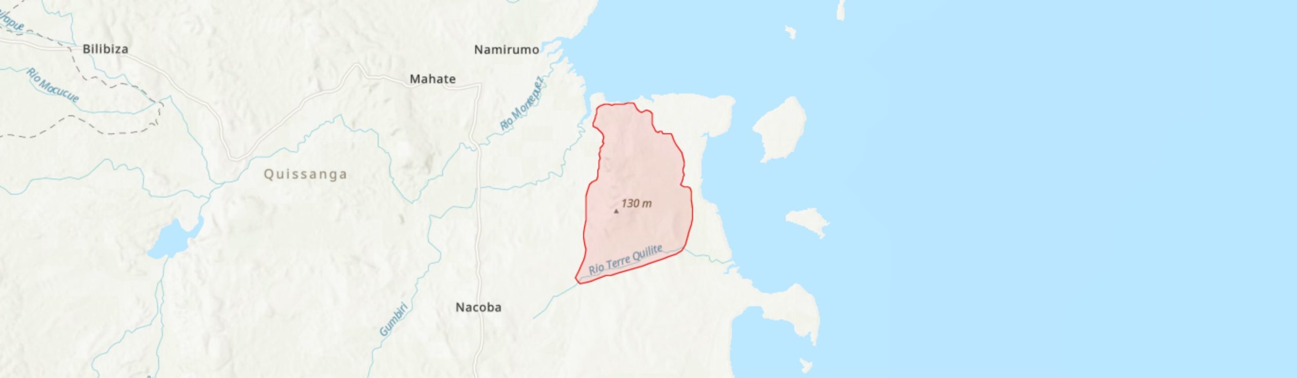
Central co-ordinates: 12.5777 S, 40.51470 E
Area: 57km²
Qualifying IPA Criteria
A(i)Site contains one or more globally threatened species, C(iii)Site contains nationally threatened or restricted habitat or vegetation types, AND/OR habitats that have severely declined in extent nationally
IPA assessment rationale
The Lupangua Peninsula qualifies as an Important Plant Area under criterion A(i), as it contains important populations of one Endangered species, Hildegardia migeodii, and two Vulnerable species, Micklethwaitia carvalhoi and Premna schliebenii. It is believed to be the most important site globally for the Micklethwaitia, and so also qualifies under criterion C(iii) in containing over 10% of the national resource of Rovuma Micklethwaitia-dominated Coastal Dry Forest. It is considered highly likely that this under-explored locality will contain other globally threatened and/or range-restricted species.
Site description
The Lupangua Peninsula IPA is located on the coast of Quissanga District in Cabo Delgado Province, northeastern Mozambique. It lies ca. 12 km to the south of the coastal fishing village of Quissanga, close to the village of Mahate. This site, with an area of 57 km2, is within the Quirimbas National Park and is adjacent to the islands of Mefunvo and Quisiva in the Quirimbas Archipelago. The peninsula comprises coastal lowlands and a series of low hills, rising up to 132 m elevation on Lupangua Hill, but with the western ridge of the peninsula reaching 80 m elevation. It contains an important example of coastal dry forest of the proposed Rovuma Centre of Plant Endemism (CoE) (Burrows & Timberlake 2011; Darbyshire et al. 2019).
Botanical significance
Lupangua is of botanical importance primarily for its ca. 25 km2 of near-pristine coastal dry forest, dominated by the globally threatened tree species Micklethwaitia carvalhoi (VU), which is endemic to Mozambique (Clarke 2010). The population of this species at Lupangua is estimated at over 10,000 individuals (Burrows et al. 2014) and is believed to be the largest and most secure population of this species globally (Clarke 2010). It was on this basis that this site was highlighted as one of the four highest priority sites for conservation in a recent review of coastal dry forests of Cabo Delgado (Timberlake et al. 2010). It is one of the few sizable remnant dry forest areas within the proposed Rovuma CoE. This site had apparently not been explored by biologists prior to a reconnaissance survey by a small team in November 2009. In addition to discovering the important Micklethwaitia population, this brief survey focusing on the western ridge also found the first known site in Mozambique for the globally Endangered Hildegardia migeodii (since also found at Pemba Bay) and a population of Premna schliebenii (VU). Other interesting discoveries included a potential new species of Erythrina, which requires further investigation, and the second known Mozambican population of Kabuyea hastifolia, a monotypic genus endemic to East Africa (Clarke 2010). The botanical inventory of this site is highly incomplete and further species of high conservation concern are likely to be uncovered following more exhaustive surveys. A provisional species list, comprising only 28 taxa, is provided by Clarke (2010).
Habitat and geology
Clarke (2010) provides a preliminary assessment of the main vegetation types of this site. The peninsula is surrounded to the north, west and east by extensive mangrove swamps and adjacent salt flats; these are not included within the IPA. Above the salt flats, the low-lying coastal areas support a coastal woodland dominated by Terminalia sambesiaca (which is common in all habitats throughout the site), Acacia nigrescens and A. robusta subsp. usambarensis; some of the woodland and wooded grassland on the peninsula appears to be secondary in nature. Further inland and upslope, there are areas of scrub forest with a broken canopy at ca. 8 m and a more complete lower canopy of ca. 3 – 4 m, with a mixed species assemblage including Dobera loranthifolia, Manilkara mochisia and Monodora junodii. On the ridges and hill tops there are large stands of Micklethwaitia-dominated coastal dry forest, typically with a canopy at ca. 8 m; Monodora junodii is co-dominant with Micklethwaitia in the understorey layer. Occasional emergent trees including Adansonia digitata are noted on parts of the peninsula. This forest type also extends down to sea level in steep gullies that are protected from fire. The soils on the surveyed parts of the peninsula are heavy clays with numerous interspersed calcareous rocks, which are also abundantly scattered on the soil surface. The Micklethwaitia forest favours well-drained soils (Clarke 2010).
Average annual rainfall at nearby Quissanga is 1,320 mm per year, with the main rainy season being December to April, with a prolonged dry season between May and November (climate-data.org).
Conservation issues
The whole of the Lupangua peninsula is contained within the Quirimbas National Park and UNESCO Biosphere Reserve, but there is no active conservation management of the site at present. The human population is currently small and the peninsula is not easily accessible as it is not served by any sizable roads. Some small non-permanent fishing settlements are found on the coast, and a large village is located to the southeast of the main forest block (Clarke 2010). Some notable expansion of agricultural activity is visible on recent satellite imagery (Google Earth 2020) which has, post-2003, encroached into the forest in the northeast and, in particular, the southeast of the site. However, the soils on the hills are thin and rocky and so unlikely to be of agricultural value. A single cut-line running north-south along the peninsula is also clearly visible on satellite imagery and probably dates back to oil exploration in the early 1980s (Clarke 2010).
The Micklethwaitia is used here as a source of poles for construction, as its timber is hard and termite resistant. However, this species coppices well and the 2009 survey found evidence of it regenerating from stumps (Clarke 2010; Burrows et al. 2018). A more significant threat is from fire to which this species appears to have very little resistance. Fires are set deliberately by humans primarily to control wild animals (Clarke 2010).
The Lupangua Peninsula is included within the Quiterajo Key Biodiversity Area.
Ecosystem services
The site is primarily of importance for its habitat and biodiversity supporting services. It is also a locally important source of materials for local communities, notably the sourcing of timber. Tourism potential at this site is low in view of its inaccessibility, and it would be favourable to keep this as such as any increase in access is likely to lead to accelerated losses of forest.
Site assessor(s)
Iain Darbyshire, Royal Botanic Gardens, Kew
Phil Clarke,
IPA criterion A species
| Species | Qualifying sub-criterion | ≥ 1% of global population | ≥ 5% of national population | 1 of 5 best sites nationally | Entire global population | Socio-economically important | Abundance at site |
|---|---|---|---|---|---|---|---|
| Micklethwaitia carvalhoi (Harms) G.P.Lewis & Schrire | A(i) |  |
|
|
 |
|
Abundant |
| Hildegardia migeodii (Exell) Kosterm. | A(i) | |
|
|
|
|
Occasional |
| Premna schliebenii Werderm. | A(i) | |
|
|
|
|
Unknown |
Micklethwaitia carvalhoi (Harms) G.P.Lewis & Schrire
Qualifying sub-criterion:
A(i)
≥ 1% of global population:
≥ 5% of national population:
1 of 5 best sites nationally:
Entire global population:
Socio-economically important:
Abundance at site:
Abundant
Hildegardia migeodii (Exell) Kosterm.
Qualifying sub-criterion:
A(i)
≥ 1% of global population:
≥ 5% of national population:
1 of 5 best sites nationally:
Entire global population:
Socio-economically important:
Abundance at site:
Occasional
Premna schliebenii Werderm.
Qualifying sub-criterion:
A(i)
≥ 1% of global population:
≥ 5% of national population:
1 of 5 best sites nationally:
Entire global population:
Socio-economically important:
Abundance at site:
Unknown
IPA criterion C qualifying habitats
| Habitat | Qualifying sub-criterion | ≥ 5% of national resource | ≥ 10% of national resource | 1 of 5 best sites nationally | Areal coverage at site |
|---|---|---|---|---|---|
| Rovuma Micklethwaitia Coastal Dry Forest | C(iii) | |
|
|
25 |
Rovuma Micklethwaitia Coastal Dry Forest
Qualifying sub-criterion:
C(iii)
≥ 5% of national resource:
≥ 10% of national resource:
Areal coverage at site:
25
General site habitats
| General site habitat | Percent coverage | Importance |
|---|---|---|
| Forest - Subtropical/Tropical Dry Forest | |
Major |
| Savanna - Moist Savanna | |
Major |
| Grassland - Subtropical/Tropical Dry Lowland Grassland | |
Minor |
| Artificial - Terrestrial - Subtropical/Tropical Heavily Degraded Former Forest | |
Minor |
Forest - Subtropical/Tropical Dry Forest
Percent coverage:
Importance:
Major
Savanna - Moist Savanna
Percent coverage:
Importance:
Major
Grassland - Subtropical/Tropical Dry Lowland Grassland
Percent coverage:
Importance:
Minor
Artificial - Terrestrial - Subtropical/Tropical Heavily Degraded Former Forest
Percent coverage:
Importance:
Minor
Land use types
| Land use type | Percent coverage | Importance |
|---|---|---|
| Nature conservation | |
Major |
| Agriculture (arable) | |
Minor |
| Harvesting of wild resources | |
Minor |
Nature conservation
Percent coverage:
Importance:
Major
Agriculture (arable)
Percent coverage:
Importance:
Minor
Harvesting of wild resources
Percent coverage:
Importance:
Minor
Threats
| Threat | Severity | Timing |
|---|---|---|
| Agriculture & aquaculture - Annual & perennial non-timber crops - Small-holder farming | Low | Ongoing - increasing |
| Natural system modifications - Fire & fire suppression - Increase in fire frequency/intensity | Low | Ongoing - trend unknown |
| Biological resource use - Gathering terrestrial plants | Low | Ongoing - trend unknown |
Agriculture & aquaculture - Annual & perennial non-timber crops - Small-holder farming
Severity:
Low
Timing:
Ongoing - increasing
Natural system modifications - Fire & fire suppression - Increase in fire frequency/intensity
Severity:
Low
Timing:
Ongoing - trend unknown
Biological resource use - Gathering terrestrial plants
Severity:
Low
Timing:
Ongoing - trend unknown
Protected areas
| Protected area name | Protected area type | Relationship with IPA | Areal overlap |
|---|---|---|---|
| Quirimbas National Park | National Park | protected/conservation area encompasses IPA | |
| Quirimbas Biosphere Reserve | UNESCO Biosphere Reserve | protected/conservation area encompasses IPA | |
Quirimbas National Park
Protected area type:
National Park
Relationship with IPA:
protected/conservation area encompasses IPA
Areal overlap:
Quirimbas Biosphere Reserve
Protected area type:
UNESCO Biosphere Reserve
Relationship with IPA:
protected/conservation area encompasses IPA
Areal overlap:
Conservation designation
| Designation name | Protected area | Relationship with IPA | Areal overlap |
|---|---|---|---|
| Quiterajo | Key Biodiversity Area | protected/conservation area encompasses IPA | |
Quiterajo
Protected area:
Key Biodiversity Area
Relationship with IPA:
protected/conservation area encompasses IPA
Areal overlap:
Management type
| Management type | Description | Year started | Year finished |
|---|---|---|---|
| Protected Area management plan in place | Ministry of Tourism (2012). Parque Nacional das Quirimbas: Plano de Maneio 2013-22. | 2013 | 2022 |
Protected Area management plan in place
Ministry of Tourism (2012). Parque Nacional das Quirimbas: Plano de Maneio 2013-22.
Year started:
2013
Year finished:
2022
Bibliography
The endemic plants of Mozambique: diversity and conservation status
PhytoKeys, Vol 136, page(s) 45-96 Available online
Report on a reconnaissance visit to Lupangua Hill, Quissanga District, Cabo Delgado Province, Mozambique, with notes about Micklethwaitia carvalhoi.
Micklethwaitia carvalhoi. The IUCN Red List of Threatened Species 2014: e.T62494244A62494265.
Coastal Dry Forests in Cabo Delgado Province, Northern Mozambique: Botany and Conservation.
Google Earth Satellite Imagery
Mozambique’s centres of endemism, with special reference to the Rovuma Centre of Endemism of NE Mozambique and SE Tanzania.
South African Journal of Botany, Vol 77, page(s) 518


Recommended citation
Iain Darbyshire, Phil Clarke (2024) Tropical Important Plant Areas Explorer: Lupangua Peninsula (Mozambique). https://tipas.kew.org/site/lupangua-peninsula-2/ (Accessed on 27/07/2024)