Country: Sierra Leone
Administrative region: Southern (Province)
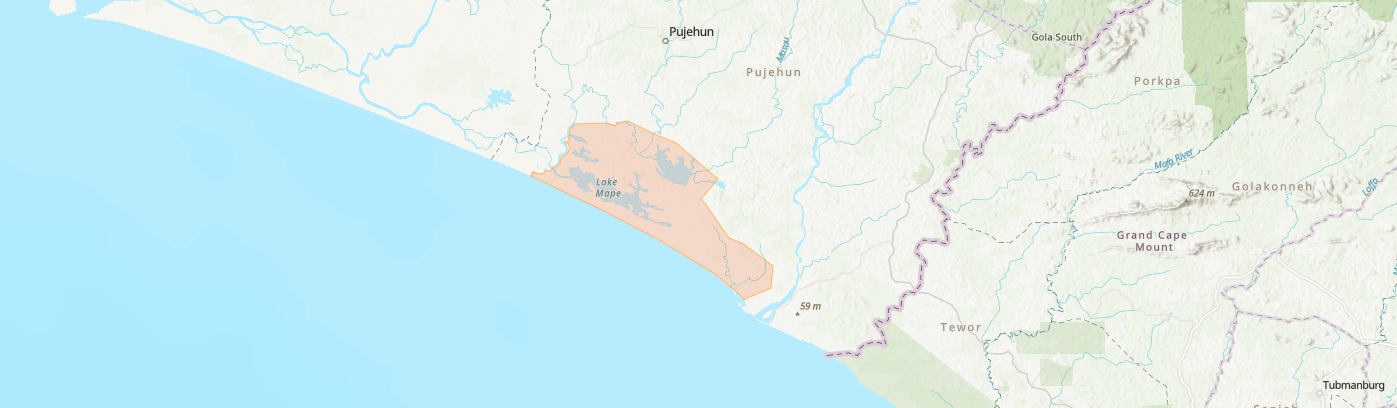
Central co-ordinates: 7.20000 N, 11.7 W
Area: 95km²
Qualifying IPA Criteria
A(i)Site contains one or more globally threatened species
IPA assessment rationale
This site qualifies as an IPA based on criterion A(i), hosting populations of two globally threatened taxa.
Site description
The Lake Mape and Mabesi IPA is situated within Pujehun District, in the Southern Province of Sierra Leone. This IPA is adjacent to the Moa River and in proximity to the coastline. The site encompasses the eponymous National Park. It also includes the Sulima Mangrove Swamp Strict Nature Reserve and Gbekema-Kanayema Forest Reserve (Protected Planet, 2024). Access to the site is notably restricted, being inaccessible by vehicle year-round and reachable only by motorbike during the dry season.
Botanical significance
This IPA is hypothesized to share botanical affinities with the Sulima IPA, approximately 16 km southward. Primary forest is documented at this site (Global Forest Watch, 2024). The IPA is critically important as it contains the only two documented occurrences of the globally threatened species Habropetalum dawei (EN), identified as a flagship species for Sierra Leone (Svahnström et al., 2023). Historical records also include notable species such as Fegimanra accumatissima (VU) and Terminalia scutifera (NT). Comprehensive botanical surveys are required to fully document the site’s floristic diversity.
Habitat and geology
The IPA includes a mosaic of habitat types, including mangroves, coastal thicket, 'coastal park savanna', freshwater lakes, swamp forest and grassland (Cole 1968, UNCCD 2004, Sankoh et al. 2016).
Mangroves are found in tidal creeks abutting small streams, and are less common than Avicennia (Acanthaceae) mangroves which are present on firmer dandy soil under more saline conditions. Rhizophora mangroves often merge with coastal thicket, dominated by Dichrostachys cinerea subsp. africana (Fabaceae) and coastal thicket is a continuation of closed forest vegetation of the upland near the coast (Cole 1968).'Coastal park savanna' (CPS) itself is a mosaic of woodland on sandy flats dissected by coastal thicket and forest on the ridges, visible in found on distinctive ridges that run parallel to the coastline on lateritic sandy soil (Cole 1968, Google Earth Imagery 2025). Species common in CPS are trees such as Chrysobalanus spp., Neocarya macrophylla and Terminalia scutifera, as well as caespitose grasses such as Ctenium newtonii and Panicum congoense (Cole, 1968). This IPA contains some of the most intact and largest stands of the CPS vegetation type. Swamp forest and grassland occur in seasonally flooded areas. Peatland has also been mapped in this region, however this is yet to be ground-truthed (Melton, J et al., 2022; Austin et al., 2025).
Conservation issues
Despite remoteness providing some natural protection, the area lacks a formal management plan and has negligible ranger presence, resulting in non-existent enforcement of park regulations. The official designation date of the national park remains unclear. Major threats within the include rice cultivation and frequent anthropogenic bushfires (UNCCD, 2004).
Habropetalum dawei is frequently harvested locally for ropes and construction materials, observed at the Sulima IPA, where it faces reproductive limitations due to frequent fires and slash-and-burn agriculture. Similar threats may also occur at this site.
Ecosystem services
The IPA provides essential ecosystem services, including nursery habitats for fish and vegetation buffering against storms and natural hazards. It supports approximately 20 small villages through provisioning services, primarily fishing. Mangrove harvesting for wood, fish smoking, and construction is prevalent, which is in conflict with the maintainance of ecosysem services they provide as habitat and protection against storms. Historically, Sierra Leone’s coastal mangroves have been heavily utilized for fish smoking, fuelwood, and traditional fishing activities (Chong, 1987; Johnson & Johnson, 1991, 1992). Environmentally, mangroves function as coastal barriers against storms, flooding, erosion, and as nursery habitats for marine fauna (Sankoh et al., 2016). The IPA also provides critical habitat for the West African manatee (Trichechus senegalensis, VU), though recent population data are lacking and numbers are presumed low due to past persecution (Reeves et al., 1988). The site’s isolation and limited accessibility currently preclude ecotourism development.
Site assessor(s)
Assessed by:
Gabriella Hoban, Royal Botanic Gardens, Kew
Date of first assessment: 15th Jan 2025
Reviewed by:Xander van der Burgt, The Royal Botanic Gardens Kew
Martin Cheek, The Royal Botanic Gardens Kew
IPA criterion A species
| Species | Qualifying sub-criterion | ≥ 1% of global population | ≥ 5% of national population | 1 of 5 best sites nationally | Entire global population | Socio-economically important | Abundance at site |
|---|---|---|---|---|---|---|---|
| Habropetalum dawei (Huchinson & Dalziel) Airy Shaw | A(i) |  |
|
|
 |
|
Unknown |
| Fegimanra acuminatissima Keay | A(i) | |
|
|
|
|
Unknown |
Habropetalum dawei (Huchinson & Dalziel) Airy Shaw
Qualifying sub-criterion:
A(i)
≥ 1% of global population:
≥ 5% of national population:
1 of 5 best sites nationally:
Entire global population:
Socio-economically important:
Abundance at site:
Unknown
Fegimanra acuminatissima Keay
Qualifying sub-criterion:
A(i)
≥ 1% of global population:
≥ 5% of national population:
1 of 5 best sites nationally:
Entire global population:
Socio-economically important:
Abundance at site:
Unknown
General site habitats
| General site habitat | Percent coverage | Importance |
|---|---|---|
| Forest - Subtropical/Tropical Swamp Forest | |
|
| Forest - Subtropical/Tropical Mangrove Forest Vegetation Above High Tide Level | |
|
| Grassland - Subtropical/Tropical Seasonally Wet/Flooded Lowland Grassland | |
|
| Wetlands (inland) - Permanent Rivers, Streams, Creeks [includes waterfalls] | |
|
| Wetlands (inland) - Bogs, Marshes, Swamps, Fens, Peatlands [generally over 8 ha] | |
|
| Savanna - Moist Savanna | |
|
| Marine Intertidal - Sandy Shoreline and/or Beaches, Sand Bars, Spits, etc. | |
|
| Other | |
Forest - Subtropical/Tropical Swamp Forest
Percent coverage:
Importance:
Forest - Subtropical/Tropical Mangrove Forest Vegetation Above High Tide Level
Percent coverage:
Importance:
Grassland - Subtropical/Tropical Seasonally Wet/Flooded Lowland Grassland
Percent coverage:
Importance:
Wetlands (inland) - Permanent Rivers, Streams, Creeks [includes waterfalls]
Percent coverage:
Importance:
Wetlands (inland) - Bogs, Marshes, Swamps, Fens, Peatlands [generally over 8 ha]
Percent coverage:
Importance:
Savanna - Moist Savanna
Percent coverage:
Importance:
Marine Intertidal - Sandy Shoreline and/or Beaches, Sand Bars, Spits, etc.
Percent coverage:
Importance:
Other
Percent coverage:
Importance:
Land use types
| Land use type | Percent coverage | Importance |
|---|---|---|
| Nature conservation | |
|
| Agriculture (arable) | |
|
| Agriculture (pastoral) | |
|
| Harvesting of wild resources | |
Nature conservation
Percent coverage:
Importance:
Agriculture (arable)
Percent coverage:
Importance:
Agriculture (pastoral)
Percent coverage:
Importance:
Harvesting of wild resources
Percent coverage:
Importance:
Protected areas
| Protected area name | Protected area type | Relationship with IPA | Areal overlap |
|---|---|---|---|
| Lake Mape/Mabesi | National Park | IPA encompasses protected/conservation area | |
| Sulima Mangrove Swamp | National Nature Reserve | IPA encompasses protected/conservation area | |
Lake Mape/Mabesi
Protected area type:
National Park
Relationship with IPA:
IPA encompasses protected/conservation area
Areal overlap:
Sulima Mangrove Swamp
Protected area type:
National Nature Reserve
Relationship with IPA:
IPA encompasses protected/conservation area
Areal overlap:
Bibliography
Google Earth Satellite Imagery
Global Forest Watch
On the Dioncophyllaceae, a remarkable new family of flowering plants
Kew Bulletin, Vol 6, page(s) 327-347
On The Implementation of the United Nations Convention to Combat Desertification
Habropetalum dawei
The IUCN Red List of Threatened Species
Distribution and exploitation of manatees in Sierra Leone." Oryx 22, no. 2 (1988): 75-84.
Oryx, Vol 22, page(s) 5-84
Intergrated Coastal Zone Management Plan for Sierra Leone 2016-2020
Mismatch Between Global Importance of Peatlands and the Extent of Their Protection
Conservation Letters, Vol 18
A Map of Global Peatland Extent Created Using Machine Learning (Peat-ML)
Geoscientific Model Development, Vol 15, page(s) 4709–4738

Recommended citation
Gabriella Hoban (2025) Tropical Important Plant Areas Explorer: Lake Mape and Mabesi (Sierra Leone). https://tipas.kew.org/site/lake-mape-and-mabesi/ (Accessed on 01/07/2025)