Country: Mozambique
Administrative region: Inhambane (Province)
Central co-ordinates: 21.72211 S, 35.18269 E
Area: 953km²
Qualifying IPA Criteria
A(i)Site contains one or more globally threatened species, A(iv)Site contains one or more range restricted endemic species that are potentially threatened, B(ii)Site contains an exceptional number of species of high conservation importance
IPA assessment rationale
Inhassoro-Vilanculos qualifies as an IPA under criterion A(i), as this area supports important populations of seven globally threatened species, namely Ecbolium hastatum (EN), Elaeodendron fruticosum (VU), Ozoroa gomesiana (VU), Psychotria amboniana subsp. mosambicensis (VU), Solanum litoraneum (EN), Triaspis suffulta (EN) and Xylia mendoncae (VU). It also qualifies under Criterion A(iv), due to the occurrence of Encephalartos ferox subsp. emersus, as this subspecies is range restricted and potentially threatened and the majority of its known global population lies within this IPA.
This IPA holds 12 national endemic species and falls within the top 15 sites nationally for endemic and range restricted species; Inhassoro-Vilanculos therefore qualifies under sub-criterion B(ii) of the IPA criteria. The coastal miombo on primary dunes is a range restricted and threatened habitat covered by this IPA which supports seven endemic species. With further research, this site may qualify under criterion C(iii) of the IPA criteria in future, due to the presence of this habitat type.
Site description
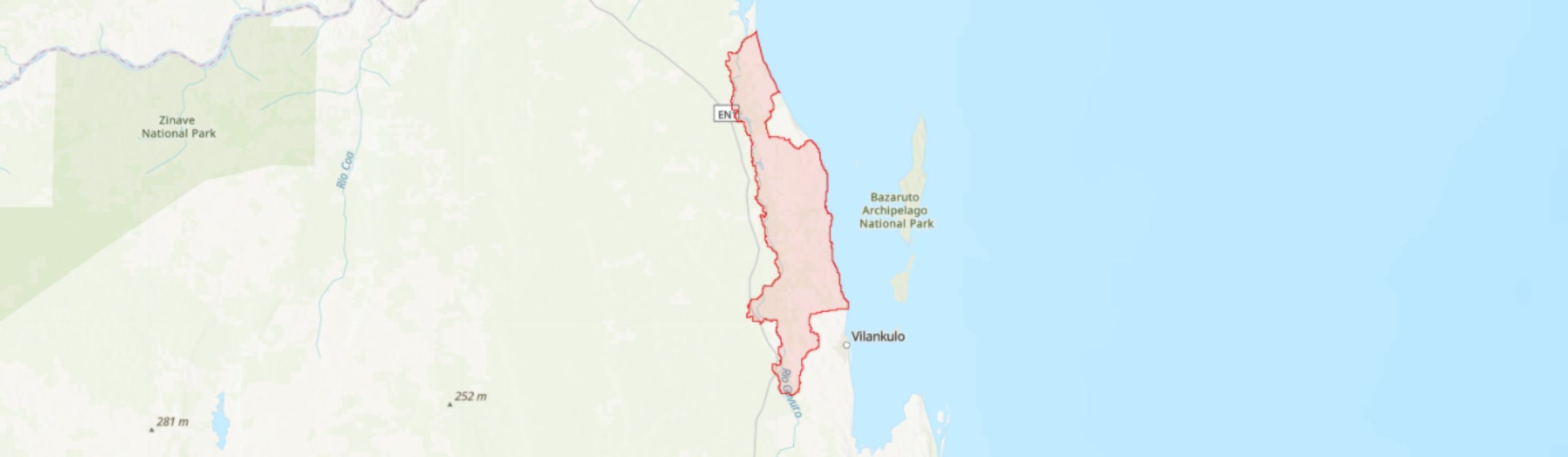
The Inhassoro-Vilanculos IPA is located along the coast of northern Inhambane Province within the Inhassoro and Vilanculos Districts. It covers an area of 953 km2 between the latitudes -21.34° to -22.11° and longitudes 35.09° to 35.4°. This IPA falls within the proposed Inhambane (sub-)Centre of Plant Endemism (CoE) (Darbyshire et al. 2019). To the east of this site is the Indian Ocean coast, while in the south is Vilanculos town, in north the mangroves of Govuro District and to the west the site boundary runs largely parallel to the EN1 road. The town of Inhassoro has been excluded from the site boundary.
The vegetation of this IPA is under significant human pressure, including the expansion of tourism which is particularly prominent along the coastal dunes (MICOA 2012; Massingue 2019). Despite the human pressure, this site contains a range of terrestrial habitats that support a notable number of plant species endemic to Mozambique, including deciduous miombo woodland, freshwater depressions, and semi-deciduous to evergreen dune thicket (Lötter et al. in prep.). In addition, Massingue (2019) notes the presence of coastal miombo on primary dunes, a range-restricted habitat that is only known from Inhassoro and Vilanculos Districts.
Neighbouring this site are Temane IPA [MOZTIPA055] to the west and Mapinhane IPA [MOZTIPA056] to the south-west, while approximately 30 – 35 km offshore is the Bazaruto Archipelago IPA [MOZTIPA042]. The site also overlaps with the Inhassoro-Vilanculos Key Biodiversity Area (KBA) but is not formally protected at present.
Botanical significance
Inhassoro-Vilanculos hosts seven range-restricted and globally threatened plant species. This includes three Endangered species: Ecbolium hastatum and the wild relative of the aubergine, Solanum litoraneum (both endemic to southern Mozambique); and the woody climber, Triaspis suffulta (a strict endemic of the Inhambane CoE). In addition, there are four Vulnerable species known from this site: Elaeodendron fruticosum (endemic to the Inhambane CoE, occurring across coastal areas of Gaza and Inhambane Provinces); Ozoroa gomesiana (a strict endemic of northern Inhambane Province, mostly within the Mapinhane, Inhassoro and Vilanculos IPAs); Psychotria amboniana subsp. mosambicensis (endemic to southern Mozambique) and Xylia mendoncae (a strict endemic of northern Inhambane Province, occurring in Vilanculos, Inhassoro and Govuro Districts). The largest population globally of X. mendoncae occurs within this IPA, which is therefore the global stronghold for this species, with more than 65% of its population estimated to be within this IPA. From satellite imagery (Google Earth 2021), it is notable that this species prefers coastal deciduous miombo woodland, with Brachystegia sp. and Julbernardia globiflora, close to freshwater depressions. The habitats around the freshwater depressions are preferred areas for machambas. Despite this, X. mendoncae appears to be able to regenerate in secondary regrowth following shifting agriculture.
A further species of conservation interest is the cycad Encephalartos ferox subsp. emersus. Provisionally assessed as Endangered, this subspecies has now been confirmed to be endemic to the Inhambane CoE, in Inhambane coastal districts of Inhassoro, Vilanculos and Jangamo (Massingue 2019), occurring on ancient termitaria in seasonally flooded coastal plains (Burrows et al. 2018). This IPA contains a majority of the global population.
This IPA holds within its boundaries 12 national endemic species and six near-endemic species. The Mozambican endemics comprise the seven previously mentioned globally threatened or potentially threatened species, plus four Least Concern species, Ammannia fernandesiana (for which this may be the most important site globally), Chamaecrista paralias, Triainolepis sancta and Zanthoxylum delagoense.
Near-endemic plant taxa known from this site include Commiphora schlechteri (LC), Crotalaria dura subsp. mozambica, Cussonia arenicola and Pavetta gracillima. Additionally of interest is the saltmarsh species Caroxylon littoralis, restricted to the coastlines on the Mozambique Channel with an Area of Occupancy of around 48 km2 (Friis & Holt 2017). This IPA represents one of only three locations for this species in Mozambique.
In addition to this, Vilanculos-Inhassoro hosts significant areas of coastal miombo on primary dunes. Throughout most of Mozambique, coastal miombo occurs towards the rear of the dune system; however, in this IPA miombo also occurs on primary dunes. Nationally this habitat is highly restricted, limited to a small area around Vilanculos and Inhassoro Districts, and is also threatened by encroaching agriculture and expanding townships (Massingue 2019). This IPA is, therefore, of great conservation importance for this habitat type.
Habitat and geology
In the broad sense, the Inhassoro-Vilanculos IPA region lies within the Swahilian-Maputaland Regional Transition Zone phytogeographical region according to Clarke (1998), covering much of coastal-belt Mozambique, and in the Southern Zanzibar-Inhambane Coastal Forest Mosaic Ecoregion according to Schipper & Burgess (2015), which stretches for ca. 2,200 km along the eastern coast of the African continent, from southern Tanzania to Xai-Xai (Gaza Province) in Mozambique. In a narrower phytogeographical sense, this IPA falls within the northern extension of the Maputaland Centre of Endemism, recently proposed as the Inhambane (sub-) CoE (Darbyshire et al. 2019), which was proposed due to the high concentration of plant endemism found only within this area (Massingue 2019).
The climate is influenced by the warm current from the Mozambique Channel and is characterized to be a humid to sub-humid tropical climate, with two seasons (Lambrechts 2003; Cumbe 2007; Massingue 2019): a hot rainy season from August to February, and a dry and relatively cool season from February to July. In the rainy season, the average temperatures vary between 28 – 30°C, while in the dry season the temperatures vary between 18 – 27°C. Average annual rainfall ranges from 865 – 936 mm, with highest rainfall on the coast (Lambrechts 2003, Governo do Distrito de Inhassoro 2011, EOH 2015a, World Resources Institute 2021). The elevation of the IPA ranges from 0 – 55 m. It is part of the great coastal plains that stretch along a large extent of coastal Mozambique and is characterized by unconsolidated sandy soils of fine texture, with a very low clay content, originated from wind and/or marine activities, interspersed with areas of hydromorphic soils and soils derived from marine sediments soils found along the coastline. Red clay soils and sodic soils (mananga soils) dominating the inland zones (MICOA 2012).
The coastal vegetation of the Inhassoro-Vilanculos IPA is highly fragmented through a combination of threats (see below). Despite this, there are still significant areas of intact coastal habitats remaining that are of high conservation concern. In recent years, this IPA has been subject to several botanical surveys, which have helped to add, update, and confirm our understanding of plant diversity in the Inhassoro IPA region and improve understanding of the mosaic of habitats within this IPA. It lies within a frequently flooded landscape and so features a range of wetland types notably: riverine floodplains with swamps, seasonal coastal streams, coastal lakes and lagoons, and mangrove forests at the coast. Among these wetlands the most important are the Nhangonzo stream by the coast in the eastern most corner of this IPA (-21.72°, 35.24°) and the Govuro River floodplain further inland to the south (-21.75°, 35.14°), dominated by emergent and inundated vegetation and characterized by the presence of Phragmites australis and Nymphaea within the water bodies, and the abundance of Hyphaene coriacea and Phoenix reclinata, associated with termite mounds (MICOA 2012; Deacon 2014).
In the east of the IPA, there is a small extent of mangroves with Rhizophora mucronata, Bruguiera gymnorrhiza, Avicennia marina and Ceriops tagal. Associated with this habitat are coastal saltmarshes, with scattered to dense samphires (Sarcocornia sp.) (MICOA 2012; Lötter et al. in prep.).
The coastal dunes support a mosaic of semi-deciduous to evergreen thicket and forest, ranging in density and structure. This vegetation type is dominated by Acacia kraussiana, A. robusta var. usambarensis, Acokanthera oblongifolia, and Acridocarpus natalitius, with plants of conservation interest including Commiphora schlechteri and, notably, Ecbolium hastatum (Lötter et al. in prep.).
Littoral miombo woodland covers significant areas of the IPA, dominated by Brachystegia spiciformis, B. torrei and Julbernardia globiflora (Lötter et al. in prep.). Towards the coastline, the canopy is more closed (75% tree and shrub cover) and the understorey is dominated by the grass Halopyrum mucronatum together with shrubby Scaevola plumieri. Further inland, the canopy is more open (35% canopy cover) and herbaceous cover is greater, featuring grasses such as Eragrostis chapelieri, Melinis repens, Perotis patens, Schizachyrium sanguineum and Sporobolus pyramidalis (Deacon 2014; EOH 2015b). Interestingly, this site also hosts miombo on primary dunes, a nationally scarce and threatened habitat known only from Vilanculos to Inhassoro, which is dominated by Julbernardia globiflora and rarely Brachystegia spiciformis (Massingue 2019). This important habitat protects inland terrestrial ecosystems from excessive marine influences and holds important plants for conservation interest including the Endangered Triaspis suffulta and Ecbolium hastatum among others.
Further inland are deciduous forest and woodland mosaics, often with an open woodland of medium-sized trees and shrubs (of 30% cover) and with an herbaceous ground cover (60%) of Megathyrsus maximus, Schizachyrium sanguineum and Sporobolus pyramidalis. This habitat holds similar tree species to the miombo woodland, with Brachystegia spiciformis and Julbernardia globiflora, but is dominated by deciduous species such as Afzelia quanzensis, Balanites maughamii, Sideroxylon inerme subsp. diospyroides, and Suregada zanzibariensis (MICOA 2012; Lötter et al. in prep.). Moreover, this habitat holds several plants of conservation interest, namely Chamaecrista paralias, Commiphora schlechteri, Psychotria amboniana subsp. mosambicensis and Zanthoxylum delagoense.
In the west of this site are a number of seasonal wetlands, associated with savanna vegetation. The woody component is dominated by Hyphaene coriacea accompanied by Albizia versicolor, Annona senegalensis, Dichrostachys cinerea, Ozoroa obovata and, Sclerocarya birrea, alongside the endemic species Chamaecrista paralias; these wetlands are also where the endemic shrubby herb Ammannia fernandesiana can be found.
Conservation issues
Despite its importance for plant diversity and endemism, the Inhassoro-Vilanculos IPA does not lie within a formal protected area. However, most of the region is included within the recently identified Inhassoro-Vilankulos KBA (WCS et al. 2021). The area is not currently recognised as a RAMSAR site, despite the diversity of wetlands which are suitable for waterbirds and migratory birds (Lambrechts 2003; Golder Associates 2014; EOH 2015a; EOH 2015b; Google Earth 2021). IMPACTO (2018) determined that 63.4 ha of thicket/coastal dune forest located in a narrow strip along the northern and southern part of the Nhangonzo Estuary qualifies as a “Critical Habitat”. Moreover, the restricted primary dune miombo, a habitat type of conservation significance, also occurs within the coastal dune vegetation (Massingue 2019).
Along the coast, the Nhangonzo humid zone has recently been subjected to drilling of pools for prospecting of petroleum and natural gas, and seismic research. These activities have increased vegetation damage by opening new access routes, and intensification of land use by local communities. However, according to the recent report by IMPACTO (2018), these areas will be no longer exploited, as it would contravene requirements present in the current exploitation license for Sasol Lda, which prohibits activities related to oil and gas exploitation within a range of 500 m from the coast.
Botanical surveys carried out in some areas of this site, especially the critical area of Nhangonzo, pointed out the existence of invasive plant species in the vicinity of villages and agricultural areas, such as Agave sisalana, Lantana camara, Melinis repens and Opuntia ficus-indica. There are also some exotic trees, such as cashew, mango and Casuarina equisetifolia, which occur in small numbers in disturbed areas (EOH 2015a, 2015b).
More generally, this IPA is currently under high pressure and degradation by local communities because of the harvesting of firewood, charcoal production, livestock grazing, agriculture with an associated increase in fire frequency, and expansion of settlements (MICOA 2012; Massingue 2019; World Resources Institute 2021; Google Earth 2021). The cultivated areas are concentrated by wetlands and along access roads and paths, and notably near Sasol’s oil flowlines which are widespread along the coastal stretch of Inhassoro IPA and themselves cause a level of habitat degradation (Deacon 2014; EOH 2015a 2015b; Google Earth 2021). It is also likely that the expansion of tourism infrastructure observed within this IPA, especially along the coastline, is also negatively affecting the integrity of the dune ecosystems, by gradually replacing the primary dune miombo vegetation (Massingue 2019).
Coastal forest and woodland restoration and prevention of further habitat loss or degradation should be considered high priorities to enable the conservation of the threatened plant species of this IPA. Urgent action is required to protect the remaining vegetation given the scale of habitat loss to date.
Ecosystem services
The ecosystem services of this IPA can be divided into terrestrial and marine/aquatic services. On the terrestrial side (the focus of the IPA), the coastal thickets and forests contribute significantly to carbon storage and climate regulation, particularly related to the precipitation cycle. In addition, they help to maintain the natural integrity of the coast by protecting against coastal erosion from the ocean and winds, as well as being important catchment basins in the protection of groundwater hydrological processes (EOH 2015a; 2015b; Massingue 2019). Further, these habitats are also important for a range of fauna (e.g. endemic reptiles such as Panaspis and Atractaspis spp.). Moreover, the local human populations also take advantage of these terrestrial habitats, where they harvest firewood, wild fruits, and medicinal plants (EOH 2015a 2015b; A. Massingue, pers. comm. 2020).
The aquatic/marine ecosystems are represented at Inhassoro-Vilanculos IPA by riverine floodplains, coastal streams, coastal lakes and lagoons, and mangroves. The mangrove forests are mostly associated with estuaries and provide several environmental, economic, and social services. They are important in preventing coastal erosion, alleviating floods and in the reproduction cycles of various species. Mangroves are also of socio-economic value, not only through their association with fishing activities but also because they are utilised by local households for construction, as a source of traditional medicines and firewood (MICOA 2012; EOH 2015a, 2015b). Some estuarine ecosystems play important ecological roles due to their high productivity, providing a source of nutrients and organic matter to other ecosystems, and providing shelter for many species and nurseries for migratory species (MICOA 2012). The wetland flats also act as corridors for fauna that utilise dense cover to move or migrate (Deacon 2014).
The tourist potential of the IPA region is concentrated on the coast and dunes (Governo do Distrito de Inhassoro 2011; MICOA 2012). However, there are also notable areas of interest in inland ecosystems, for example the wetlands that support migratory birds and therefore may have some value as a birdwatching spot.
Site assessor(s)
Assessed by:
Clayton Langa, Agricultural Research Institute of Mozambique (IIAM)
Castigo Datizua, Agricultural Research Institute of Mozambique (IIAM)
Iain Darbyshire, Royal Botanic Gardens, Kew
Sophie Richards, Royal Botanic Gardens, Kew
IPA criterion A species
| Species | Qualifying sub-criterion | ≥ 1% of global population | ≥ 5% of national population | 1 of 5 best sites nationally | Entire global population | Socio-economically important | Abundance at site |
|---|---|---|---|---|---|---|---|
| Ecbolium hastatum Vollesen | A(i) |  |
|
|
 |
|
Unknown |
| Elaeodendron fruticosum N.Robson | A(i) | |
|
|
|
|
Unknown |
| Psychotria amboniana K.Schum. subsp. mosambicensis (E.M.A.Petit) Verdc. | A(i) | |
|
|
|
|
Occasional |
| Ozoroa gomesiana R.Fern. & A.Fern. | A(i) | |
|
|
|
|
Common |
| Xylia mendoncae Torre | A(i) | |
|
|
|
|
Occasional |
| Triaspis suffulta Launert | A(i) | |
|
|
|
|
Scarce |
| Encephalartos ferox G.Bertol subsp. emersus P.Rousseau, Vorster & A.E.van Wyk | A(iv) | |
|
|
|
|
Scarce |
| Solanum litoraneum A.E.Gonç. | A(i) | |
|
|
|
|
Common |
Ecbolium hastatum Vollesen
Qualifying sub-criterion:
A(i)
≥ 1% of global population:
≥ 5% of national population:
1 of 5 best sites nationally:
Entire global population:
Socio-economically important:
Abundance at site:
Unknown
Elaeodendron fruticosum N.Robson
Qualifying sub-criterion:
A(i)
≥ 1% of global population:
≥ 5% of national population:
1 of 5 best sites nationally:
Entire global population:
Socio-economically important:
Abundance at site:
Unknown
Psychotria amboniana K.Schum. subsp. mosambicensis (E.M.A.Petit) Verdc.
Qualifying sub-criterion:
A(i)
≥ 1% of global population:
≥ 5% of national population:
1 of 5 best sites nationally:
Entire global population:
Socio-economically important:
Abundance at site:
Occasional
Ozoroa gomesiana R.Fern. & A.Fern.
Qualifying sub-criterion:
A(i)
≥ 1% of global population:
≥ 5% of national population:
1 of 5 best sites nationally:
Entire global population:
Socio-economically important:
Abundance at site:
Common
Xylia mendoncae Torre
Qualifying sub-criterion:
A(i)
≥ 1% of global population:
≥ 5% of national population:
1 of 5 best sites nationally:
Entire global population:
Socio-economically important:
Abundance at site:
Occasional
Triaspis suffulta Launert
Qualifying sub-criterion:
A(i)
≥ 1% of global population:
≥ 5% of national population:
1 of 5 best sites nationally:
Entire global population:
Socio-economically important:
Abundance at site:
Scarce
Encephalartos ferox G.Bertol subsp. emersus P.Rousseau, Vorster & A.E.van Wyk
Qualifying sub-criterion:
A(iv)
≥ 1% of global population:
≥ 5% of national population:
1 of 5 best sites nationally:
Entire global population:
Socio-economically important:
Abundance at site:
Scarce
Solanum litoraneum A.E.Gonç.
Qualifying sub-criterion:
A(i)
≥ 1% of global population:
≥ 5% of national population:
1 of 5 best sites nationally:
Entire global population:
Socio-economically important:
Abundance at site:
Common
General site habitats
| General site habitat | Percent coverage | Importance |
|---|---|---|
| Savanna - Dry Savanna | |
Major |
| Forest - Subtropical/Tropical Dry Forest | |
Major |
| Shrubland - Subtropical/Tropical Dry Shrubland | |
Major |
| Marine Intertidal - Salt Marshes (Emergent Grasses) | |
Minor |
| Marine Coastal/Supratidal - Coastal Sand Dunes | |
Major |
| Artificial - Terrestrial - Arable Land | |
Minor |
| Savanna - Moist Savanna | |
Major |
| Forest - Subtropical/Tropical Mangrove Forest Vegetation Above High Tide Level | |
Minor |
| Wetlands (inland) - Seasonal/Intermittent/Irregular Rivers, Streams, Creeks | |
Minor |
Savanna - Dry Savanna
Percent coverage:
Importance:
Major
Forest - Subtropical/Tropical Dry Forest
Percent coverage:
Importance:
Major
Shrubland - Subtropical/Tropical Dry Shrubland
Percent coverage:
Importance:
Major
Marine Intertidal - Salt Marshes (Emergent Grasses)
Percent coverage:
Importance:
Minor
Marine Coastal/Supratidal - Coastal Sand Dunes
Percent coverage:
Importance:
Major
Artificial - Terrestrial - Arable Land
Percent coverage:
Importance:
Minor
Savanna - Moist Savanna
Percent coverage:
Importance:
Major
Forest - Subtropical/Tropical Mangrove Forest Vegetation Above High Tide Level
Percent coverage:
Importance:
Minor
Wetlands (inland) - Seasonal/Intermittent/Irregular Rivers, Streams, Creeks
Percent coverage:
Importance:
Minor
Land use types
| Land use type | Percent coverage | Importance |
|---|---|---|
| Agriculture (arable) | |
Major |
| Tourism / Recreation | |
Minor |
| Extractive industry | |
Minor |
| Residential / urban development | |
Major |
| Harvesting of wild resources | |
Major |
| Forestry | |
Unknown |
Agriculture (arable)
Percent coverage:
Importance:
Major
Tourism / Recreation
Percent coverage:
Importance:
Minor
Extractive industry
Percent coverage:
Importance:
Minor
Residential / urban development
Percent coverage:
Importance:
Major
Harvesting of wild resources
Percent coverage:
Importance:
Major
Forestry
Percent coverage:
Importance:
Unknown
Threats
| Threat | Severity | Timing |
|---|---|---|
| Residential & commercial development - Housing & urban areas | Medium | Ongoing - trend unknown |
| Residential & commercial development - Tourism & recreation areas | Medium | Ongoing - trend unknown |
| Agriculture & aquaculture - Annual & perennial non-timber crops - Shifting agriculture | Medium | Ongoing - trend unknown |
| Biological resource use - Logging & wood harvesting | Medium | Ongoing - trend unknown |
| Residential & commercial development - Commercial & industrial areas | Medium | Ongoing - trend unknown |
| Agriculture & aquaculture - Livestock farming & ranching - Small-holder grazing, ranching or farming | Low | Ongoing - trend unknown |
| Energy production & mining - Oil & gas drilling | Medium | Ongoing - trend unknown |
| Energy production & mining - Mining & quarrying | Unknown | Ongoing - trend unknown |
| Transportation & service corridors - Roads & railroads | High | Ongoing - trend unknown |
| Natural system modifications - Fire & fire suppression - Increase in fire frequency/intensity | Unknown | Ongoing - trend unknown |
| Invasive & other problematic species, genes & diseases - Invasive non-native/alien species/diseases | Medium | Ongoing - trend unknown |
| Human intrusions & disturbance - Recreational activities | High | Ongoing - trend unknown |
Residential & commercial development - Housing & urban areas
Severity:
Medium
Timing:
Ongoing - trend unknown
Residential & commercial development - Tourism & recreation areas
Severity:
Medium
Timing:
Ongoing - trend unknown
Agriculture & aquaculture - Annual & perennial non-timber crops - Shifting agriculture
Severity:
Medium
Timing:
Ongoing - trend unknown
Biological resource use - Logging & wood harvesting
Severity:
Medium
Timing:
Ongoing - trend unknown
Residential & commercial development - Commercial & industrial areas
Severity:
Medium
Timing:
Ongoing - trend unknown
Agriculture & aquaculture - Livestock farming & ranching - Small-holder grazing, ranching or farming
Severity:
Low
Timing:
Ongoing - trend unknown
Energy production & mining - Oil & gas drilling
Severity:
Medium
Timing:
Ongoing - trend unknown
Energy production & mining - Mining & quarrying
Severity:
Unknown
Timing:
Ongoing - trend unknown
Transportation & service corridors - Roads & railroads
Severity:
High
Timing:
Ongoing - trend unknown
Natural system modifications - Fire & fire suppression - Increase in fire frequency/intensity
Severity:
Unknown
Timing:
Ongoing - trend unknown
Invasive & other problematic species, genes & diseases - Invasive non-native/alien species/diseases
Severity:
Medium
Timing:
Ongoing - trend unknown
Human intrusions & disturbance - Recreational activities
Severity:
High
Timing:
Ongoing - trend unknown
Conservation designation
| Designation name | Protected area | Relationship with IPA | Areal overlap |
|---|---|---|---|
| Inhassoro-Vilankulos | Key Biodiversity Area | protected/conservation area overlaps with IPA | 70 |
Inhassoro-Vilankulos
Protected area:
Key Biodiversity Area
Relationship with IPA:
protected/conservation area overlaps with IPA
Areal overlap:
70
Management type
| Management type | Description | Year started | Year finished |
|---|---|---|---|
| No management plan in place | |
|
No management plan in place
Year started:
Year finished:
Bibliography
The endemic plants of Mozambique: diversity and conservation status
PhytoKeys, Vol 136, page(s) 45-96 Available online
Trees and Shrubs Mozambique
Google Earth Satellite Imagery
Global Forest Watch
Ecological Assessment and Biogeography of Coastal Vegetation and Flora in Southern Mozambique
Historical Vegetation Map and Red List of Ecosystems Assessment for Mozambique – Version 1.0 – Final report
Salsola sp. A of Flora Zambesiaca from the coast of Mozambique is Caroxylon littoralis (Amaranthaceae subfam. Salsoloideae), hitherto only known from Madagascar
Webbia, Vol 72, page(s) 63-69 Available online
O Património Geológico de Moçambique: Proposta de Metodologia de Inventariação, Caracterização e Avaliação
Biodiversity Management Plan for Vilanculos Coastal Wildlife Sanctuary
Perfil Ambiental e Mapeamento do Uso Actual da Terra nos Distritos da Zona Costeira de Moçambique: Distrito de Vilankulos
A new regional centre of endemism in Africa. Aspects of the ecology, taxonomy and chorology of the floras of Africa and Madagascar.
Kew Bulletin Additional Series (pub. Royal Botanic Gardens, Kew)
Environmental Impact Assessment for Sasol PSA and LPG Project: Terrestrial Fauna Impact Assessment. Specialist Report 10. SASOL Petroleum Mozambique Limitada & Sasol Petroleum Temane Lda
Nhangonzo Coastal Stream Critical Habitat Biodiversity Assessment: Integrated Summary Report.
Nhangonzo Coastal Stream Critical Habitat Biodiversity Assessment: Vegetation and Floristic Baseline Survey.
Sasol Petroleum Mozambique Limitada and Sasol Petroleum Temane Limitada. PSA Development and LPG Project, Final Impact Assessment Report. Report Number: 1302793-12655-6.
Plano Estratégico de Desenvolvimento Distrital (2011-2015)
Sasol Petroleum Mozambique. Categorização da Área de Nhangonzo, Inhambane, Moçambique. Referência do Documento: MSSP1701-IMP180407 – Rev 01.
Southern-east Africa: Mozambique, Tanzania, Malawi and Zimbabwe
Key Biodiversity Areas (KBAs) Identified in Mozambique: Factsheets VOL. II. Red List of threatened species and ecosystems, identification and mapping of key biodiversity areas (KBAs) in Mozambique. USAID / SPEED+

Recommended citation
Clayton Langa, Castigo Datizua, Iain Darbyshire, Sophie Richards (2025) Tropical Important Plant Areas Explorer: Inhassoro-Vilanculos (Mozambique). https://tipas.kew.org/site/inhassoro-vilanculos/ (Accessed on 30/06/2025)