Country: Cameroon
Administrative region: Southwest (Region)
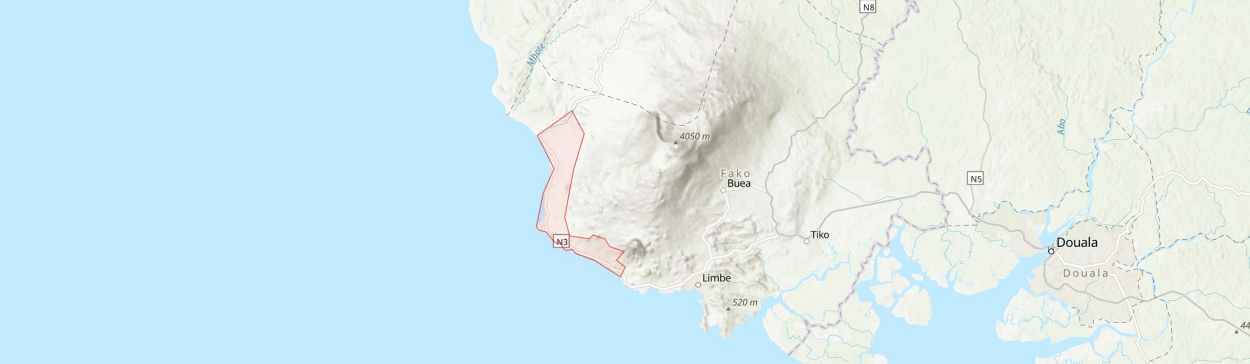
Central co-ordinates: 4.09400 N, 9.01300 E
Area: 114km²
Qualifying IPA Criteria
A(i)Site contains one or more globally threatened species
IPA assessment rationale
Although little natural habitat remains, the many rare and threatened species recorded from this area qualify it as an IPA under criterion A(i).
Site description
The Idenau-Batoke coastal forest is a much degraded but unique, very wet, lowland evergreen rain forest strip beneath the boundary of the Mt Cameroon National Park. The area here demarcated includes 114 km2 but this includes approximately 55 km2 designated as palm oil plantations, as well as other cultivated and degraded areas and the settlements of Idenau, Njonji, Bakingili and Cape Debundscha. Populations of several recorded species may already be lost from this site. The site borders three other proposed IPAs, Mt Cameroon National Park, Mokoko-Onge, and Eastern Mt Cameroon. While several species are shared with one or more of these sites, major variation in local climate and topography, as well as the highly threatened status of these other sites, justify its additional inclusion.


Botanical significance
The much larger total area of the Mt Cameroon massif contains the highest recorded diversity of vascular plants in tropical Africa with 2345 species (Cable & Cheek, 1998). It is the only remaining area in Africa with a continuous gradient of vegetation from lowland rainforest at sea-level to subalpine summit grassland (Cheek et al., 1996; Forboseh et al., 2011). Although a large part of this is protected as the Mt Cameroon National Park, the lower slopes and foothills of the massif lie largely outside this zone, are highly threatened, and are botanically very significant due to the rarity of lowland coastal forest and the exceptional climate conditions created by Mt Cameroon. In contrast, many species from the upper areas are more secure from immediate threats and often occur at several other montane sites along the Cameroon volcanic line (Cable & Cheek, 1998).
At least one species, Carappa littoralis (provisionally EN) is considered globally endemic to these remaining scraps of forest. A large proportion of the other listed threatened species, and also several not listed here but included for Mt Cameroon N.P., are found close to the boundary of the National Park which is imperfectly protected and suffering from incursions and border effects. It is unlikely that these populations can survive without efforts to conserve and restore habitat below the N.P. boundary.
Habitat and geology
At over 4000m and by far the highest peak in West and Central Africa, Mt Cameroon has a profound influence on local climate, with great variation in rainfall even along the c.30 km length of this coastal site. Cape Debundscha is considered one of the wettest places on earth, frequently cited as having an average of over 10 m of rain per year based on data from Courade (1974). More recently published long term annual averages extending from 1965-1993 show this reduced somewhat to 9086 mm, with a maximum of nearly 17 m (Fraser et al., 1998). Rainfall is also very high further west at Idenau, with a mean of 8392 per annum. However, at Mokundange at the southeastern tip of this site, only 19 km from Debundscha, the mean per annum drops to 4935 mm. Further inland (outside the site) only 2-3 m falls in the rainshadow on Mt Cameroon's eastern flanks. Rainfall is strongly seasonal throughout the site, with southwesterly prevailing winds driving a wet season peaking in July and August, and then replaced by the dry and dusty northeasterly Harmattan as the intertropical convergence zone moves south. At Mokundange, there is frequently less than 50 mm of rain per month during December and January.
Mean monthly maximum and minimum temperatures vary very little seasonally but minima are a few degrees lower at Mokundange (17.1-18.9 °C) than at Debuschanda (21.6-23.3 °C) and maxima a little higher (27.9-31.7 versus 27.2-30 °C).
Mt Cameroon is the only active volcano in mainland Africa west of the Virunga mountains in eastern DRC. It is formed of alkali basalt and basanite lavas overlying Cretacious to Miocene (or more recent) sediments, which in turn rest on precambrian metamorphic basement rocks (Dereulle et al, 1987; Mathieu et al., 2011). The mountain is considered to be a horst structure by Dereulle et al., 1987): ie. its height is constituted by uplift from below rather than just by accumulation of lava. The age of surface lavas is unclear, with upper Mioecene age estimated by Vincent (1971) and 10 Ma by Fitton (1983) but <3 Ma by Marzoli et al. (2000) and other sources (Mathieu et al., 2011), and recent geological dating suggesting 1-2 Ma (Wembenyui et al. 2020). The unusual nephelinitc lava (Etindite) of Mt Etinde, the southern slopes of which are partly located within this TIPA site, have been dated to 0.65 Ma and are considered approximately simultaneous with Mt Cameroon (Nkoumbou et al, 1995; Ntoumbe et al., 2016) but have previously been estimated to represent an earlier, Miocene, volcanic formation to the main massif (Dereulle et al., 1987; Cable & Cheek, 1998). Seven eruptions were recorded in the 20th century from various Mt Cameroon vents, with a further brief eruption in 2012. Only two of these eruptions, reached this site, the 1922 eruption which flowed down the western slope to meet the sea at Bibundi-Idenau and the 1999 eruption which descended 2500 m down the southern flank to stop just before the sea to the west of Bakingili (Geiger et al., 2016). Recent alluvial soils are also exposed near Idenau (Cable & Cheek, 1999). The soils of this coastal strip, except around Etinde and the insufficiently weathered 20th century lavas, are generally highly fertile and have been targeted for agri-plantations, while further west in the Onge reserve area they are apparently less rich and contain areas of white sand (Cable & Cheek, 1999). Many cinder cones are also present on the southern flanks, a few of these within the site boundaries.
Conservation issues
Much of the coastal strip between the lower National Park boundary and the coast has already been replaced with oil palm plantations where the original vegetation is entirely destroyed (MINFOF & WRI, 2021). Outside the plantations, small-scale agriculture and logging have severely degraded most of the area (Birdlife International, 2021). A hard-surfaced road also runs between Idenau and LImbe, separating the extreme coastal fringe from the mountain and connecting the various settlements. Limbe is now connected to Mokundange and Batoke by continuous urban sprawl which has engulfed former plantation areas. A major new "Limbe Deep Sea Port" is planned at Ngeme, east of Mokundange, which is anticipated to bring 20,000 jobs and stimulate development in the area (Ngah, 2016;. There is also an oil refinery at Mokundange and there is oil prospecting in the area. According to Birdlife International (2021), the best surviving forest of the whole mountain is around Mt Etinde, which has its lower slopes outside the National Park partly in this proposed IPA. Continued development around Batoke and the deep sea port will inevitably further threaten these slopes unless serious conservation efforts are made. The port is also anticipated to increase tourism to the area which, if managed well, could be positive for conservation (Olsen et al., 2001). The DFID and German Government funded Mount Cameroon Project, established in 1994, funded development projects in the area in collaboration with MINEF under a Participatory Biodiversity Conservation Strategy. The proposed IPA area incorporates the Bakingili community forest, established in 2000. REDD+ initiatives have been developed elsewhere around the mountain but apparently not in this area (Awono et al., 2014). Native reforestation efforts within exhausted palm oil plantation zones could be investigated and could be worthwhile because of the unique climate conditions; such projects have been implemented elsewhere on the mountain (ERUDEF, 2021; Truscott, 2021).
Ecosystem services
The area has great potential for ecotourism which could be increased if coastal forests were able to regenerate. Landslides and flooding are a risk to local communities and are mitigated by forested slopes (Payton, 1993; Thierry et al., 2008; Mathieu et al., 2011). The site would previously have helped support the rich fauna of the area but its value has been greatly diminished in this respect.
Site assessor(s)
Bruce Murphy, Royal Botanic Gardens, Kew
IPA criterion A species
| Species | Qualifying sub-criterion | ≥ 1% of global population | ≥ 5% of national population | 1 of 5 best sites nationally | Entire global population | Socio-economically important | Abundance at site |
|---|---|---|---|---|---|---|---|
| Belonophora ongensis S.E.Dawson & Cheek | A(i), A(iii) |  |
 |
|
|
|
|
| Ardisia schlechteri Gilg | A(i) | |
|
|
|
|
|
| Chlorophytum petrophilum K.Krause | A(i) | |
|
|
|
|
|
| Cola praecuta Brenan & Keay | A(i) | |
|
|
|
|
|
| Pavetta brachycalyx Hiern | A(i) | |
|
|
|
|
|
| Uvariopsis korupensis Gereau & Kenfack | A(i) | |
|
|
|
|
|
| Psychotria elephantina Lachenaud & Cheek | A(i) | |
|
|
|
|
|
| Anopyxis klaineana (Pierre) Engl. | A(i) | |
|
|
|
|
|
| Diospyros crassiflora Hiern | A(i) | |
|
|
|
|
|
| Uvariodendron giganteum (Engl.) R.E.Fr. | A(i) | |
|
|
|
|
|
| Vepris lecomteana (Pierre) Cheek & T.Heller | A(i) | |
|
|
|
|
|
| Deinbollia maxima Gilg ex Engl. | A(i) | |
|
|
|
|
|
| Leplaea thompsonii (Sprague & Hutch.) E.J.M.Koenen & J.J.de Wilde | A(i) | |
|
|
|
|
|
| Piptostigma macrophyllum Ghogue, Sonké & Couvreur | A(i) | |
|
|
|
|
|
| Leeuwenbergia africana Letouzey & N.Hallé | A(i) | |
|
|
|
|
|
| Boutiquea platypetala (Engl. & Diels) Le Thomas | A(i) | |
|
|
|
|
|
| Begonia mbangaensis Sosef | A(i) | |
|
|
|
|
|
| Leptoderris aurantiaca, Leguminosae | A(i) | |
|
|
|
|
|
| Drypetes staudtii (Pax) Hutch. | A(i) | |
|
|
|
|
|
| Afrofittonia silvestris Lindau | A(i) | |
|
|
|
|
|
| Strychnos staudtii Gilg | A(i) | |
|
|
|
|
|
| Hymenocoleus glaber Robbr. | A(i) | |
|
|
|
|
|
| Psychotria podocarpa Petit | A(i) | |
|
|
|
|
|
| Rutidea nigerica Bridson | A(i) | |
|
|
|
|
|
| Dorstenia prorepens Engl. | A(i) | |
|
|
|
|
|
| Psychotria darwiniana Cheek | A(i) | |
|
|
|
|
|
| Psychotria asterogramma O.Lachenaud | A(i) | |
|
|
|
|
|
| Impatiens hians Hook.f. var. bipindensis (Gilg) Grey-Wilson | A(i) | |
|
|
|
|
|
| Cheirostylis divina (Guinea) Summerh. var. ochyrae Szlach. & Olszewski | A(i) | |
|
|
|
|
|
| Uvariopsis zenkeri Engl. | A(i) | |
|
|
|
|
|
| Chazaliella obanensis (Wernham) Petit & Verdc. | A(i) | |
|
|
|
|
|
| Eugenia kameruniana Engl. | A(i) | |
|
|
|
|
|
| Diospyros korupensis Gosline | A(i) | |
|
|
|
|
|
| Allophylus zenkeri Gilg ex Radlk. | A(i) | |
|
|
|
|
|
| Drypetes burnleyae Cheek | A(i) | |
|
|
|
|
|
| Bulbophyllum porphyrostachys Summerh. | A(i) | |
|
|
|
|
|
| Asystasia lindauiana Hutch. & Dalziel | A(i) | |
|
|
|
|
|
| Mischogyne gabonensis (Pellegr. ex Le Thomas) Gosline | A(i) | |
|
|
|
|
|
| Pachylobus igaganga (Aubrév. & Pellegr.) Byng & Christenh. | A(i) | |
|
|
|
|
|
| Garcinia afzelii Engl. | A(i) | |
|
|
|
|
|
| Globulostylis minor Wernham | A(iii) | |
|
|
|
|
|
| Rinorea dewitii Achound. | A(i) | |
|
|
|
|
Belonophora ongensis S.E.Dawson & Cheek
Qualifying sub-criterion:
A(i), A(iii)
≥ 1% of global population:
≥ 5% of national population:
1 of 5 best sites nationally:
Entire global population:
Socio-economically important:
Abundance at site:
Ardisia schlechteri Gilg
Qualifying sub-criterion:
A(i)
≥ 1% of global population:
≥ 5% of national population:
1 of 5 best sites nationally:
Entire global population:
Socio-economically important:
Abundance at site:
Chlorophytum petrophilum K.Krause
Qualifying sub-criterion:
A(i)
≥ 1% of global population:
≥ 5% of national population:
1 of 5 best sites nationally:
Entire global population:
Socio-economically important:
Abundance at site:
Cola praecuta Brenan & Keay
Qualifying sub-criterion:
A(i)
≥ 1% of global population:
≥ 5% of national population:
1 of 5 best sites nationally:
Entire global population:
Socio-economically important:
Abundance at site:
Pavetta brachycalyx Hiern
Qualifying sub-criterion:
A(i)
≥ 1% of global population:
≥ 5% of national population:
1 of 5 best sites nationally:
Entire global population:
Socio-economically important:
Abundance at site:
Uvariopsis korupensis Gereau & Kenfack
Qualifying sub-criterion:
A(i)
≥ 1% of global population:
≥ 5% of national population:
1 of 5 best sites nationally:
Entire global population:
Socio-economically important:
Abundance at site:
Psychotria elephantina Lachenaud & Cheek
Qualifying sub-criterion:
A(i)
≥ 1% of global population:
≥ 5% of national population:
1 of 5 best sites nationally:
Entire global population:
Socio-economically important:
Abundance at site:
Anopyxis klaineana (Pierre) Engl.
Qualifying sub-criterion:
A(i)
≥ 1% of global population:
≥ 5% of national population:
1 of 5 best sites nationally:
Entire global population:
Socio-economically important:
Abundance at site:
Diospyros crassiflora Hiern
Qualifying sub-criterion:
A(i)
≥ 1% of global population:
≥ 5% of national population:
1 of 5 best sites nationally:
Entire global population:
Socio-economically important:
Abundance at site:
Uvariodendron giganteum (Engl.) R.E.Fr.
Qualifying sub-criterion:
A(i)
≥ 1% of global population:
≥ 5% of national population:
1 of 5 best sites nationally:
Entire global population:
Socio-economically important:
Abundance at site:
Vepris lecomteana (Pierre) Cheek & T.Heller
Qualifying sub-criterion:
A(i)
≥ 1% of global population:
≥ 5% of national population:
1 of 5 best sites nationally:
Entire global population:
Socio-economically important:
Abundance at site:
Deinbollia maxima Gilg ex Engl.
Qualifying sub-criterion:
A(i)
≥ 1% of global population:
≥ 5% of national population:
1 of 5 best sites nationally:
Entire global population:
Socio-economically important:
Abundance at site:
Leplaea thompsonii (Sprague & Hutch.) E.J.M.Koenen & J.J.de Wilde
Qualifying sub-criterion:
A(i)
≥ 1% of global population:
≥ 5% of national population:
1 of 5 best sites nationally:
Entire global population:
Socio-economically important:
Abundance at site:
Piptostigma macrophyllum Ghogue, Sonké & Couvreur
Qualifying sub-criterion:
A(i)
≥ 1% of global population:
≥ 5% of national population:
1 of 5 best sites nationally:
Entire global population:
Socio-economically important:
Abundance at site:
Leeuwenbergia africana Letouzey & N.Hallé
Qualifying sub-criterion:
A(i)
≥ 1% of global population:
≥ 5% of national population:
1 of 5 best sites nationally:
Entire global population:
Socio-economically important:
Abundance at site:
Boutiquea platypetala (Engl. & Diels) Le Thomas
Qualifying sub-criterion:
A(i)
≥ 1% of global population:
≥ 5% of national population:
1 of 5 best sites nationally:
Entire global population:
Socio-economically important:
Abundance at site:
Begonia mbangaensis Sosef
Qualifying sub-criterion:
A(i)
≥ 1% of global population:
≥ 5% of national population:
1 of 5 best sites nationally:
Entire global population:
Socio-economically important:
Abundance at site:
Leptoderris aurantiaca, Leguminosae
Qualifying sub-criterion:
A(i)
≥ 1% of global population:
≥ 5% of national population:
1 of 5 best sites nationally:
Entire global population:
Socio-economically important:
Abundance at site:
Drypetes staudtii (Pax) Hutch.
Qualifying sub-criterion:
A(i)
≥ 1% of global population:
≥ 5% of national population:
1 of 5 best sites nationally:
Entire global population:
Socio-economically important:
Abundance at site:
Afrofittonia silvestris Lindau
Qualifying sub-criterion:
A(i)
≥ 1% of global population:
≥ 5% of national population:
1 of 5 best sites nationally:
Entire global population:
Socio-economically important:
Abundance at site:
Strychnos staudtii Gilg
Qualifying sub-criterion:
A(i)
≥ 1% of global population:
≥ 5% of national population:
1 of 5 best sites nationally:
Entire global population:
Socio-economically important:
Abundance at site:
Hymenocoleus glaber Robbr.
Qualifying sub-criterion:
A(i)
≥ 1% of global population:
≥ 5% of national population:
1 of 5 best sites nationally:
Entire global population:
Socio-economically important:
Abundance at site:
Psychotria podocarpa Petit
Qualifying sub-criterion:
A(i)
≥ 1% of global population:
≥ 5% of national population:
1 of 5 best sites nationally:
Entire global population:
Socio-economically important:
Abundance at site:
Rutidea nigerica Bridson
Qualifying sub-criterion:
A(i)
≥ 1% of global population:
≥ 5% of national population:
1 of 5 best sites nationally:
Entire global population:
Socio-economically important:
Abundance at site:
Dorstenia prorepens Engl.
Qualifying sub-criterion:
A(i)
≥ 1% of global population:
≥ 5% of national population:
1 of 5 best sites nationally:
Entire global population:
Socio-economically important:
Abundance at site:
Psychotria darwiniana Cheek
Qualifying sub-criterion:
A(i)
≥ 1% of global population:
≥ 5% of national population:
1 of 5 best sites nationally:
Entire global population:
Socio-economically important:
Abundance at site:
Psychotria asterogramma O.Lachenaud
Qualifying sub-criterion:
A(i)
≥ 1% of global population:
≥ 5% of national population:
1 of 5 best sites nationally:
Entire global population:
Socio-economically important:
Abundance at site:
Impatiens hians Hook.f. var. bipindensis (Gilg) Grey-Wilson
Qualifying sub-criterion:
A(i)
≥ 1% of global population:
≥ 5% of national population:
1 of 5 best sites nationally:
Entire global population:
Socio-economically important:
Abundance at site:
Cheirostylis divina (Guinea) Summerh. var. ochyrae Szlach. & Olszewski
Qualifying sub-criterion:
A(i)
≥ 1% of global population:
≥ 5% of national population:
1 of 5 best sites nationally:
Entire global population:
Socio-economically important:
Abundance at site:
Uvariopsis zenkeri Engl.
Qualifying sub-criterion:
A(i)
≥ 1% of global population:
≥ 5% of national population:
1 of 5 best sites nationally:
Entire global population:
Socio-economically important:
Abundance at site:
Chazaliella obanensis (Wernham) Petit & Verdc.
Qualifying sub-criterion:
A(i)
≥ 1% of global population:
≥ 5% of national population:
1 of 5 best sites nationally:
Entire global population:
Socio-economically important:
Abundance at site:
Eugenia kameruniana Engl.
Qualifying sub-criterion:
A(i)
≥ 1% of global population:
≥ 5% of national population:
1 of 5 best sites nationally:
Entire global population:
Socio-economically important:
Abundance at site:
Diospyros korupensis Gosline
Qualifying sub-criterion:
A(i)
≥ 1% of global population:
≥ 5% of national population:
1 of 5 best sites nationally:
Entire global population:
Socio-economically important:
Abundance at site:
Allophylus zenkeri Gilg ex Radlk.
Qualifying sub-criterion:
A(i)
≥ 1% of global population:
≥ 5% of national population:
1 of 5 best sites nationally:
Entire global population:
Socio-economically important:
Abundance at site:
Drypetes burnleyae Cheek
Qualifying sub-criterion:
A(i)
≥ 1% of global population:
≥ 5% of national population:
1 of 5 best sites nationally:
Entire global population:
Socio-economically important:
Abundance at site:
Bulbophyllum porphyrostachys Summerh.
Qualifying sub-criterion:
A(i)
≥ 1% of global population:
≥ 5% of national population:
1 of 5 best sites nationally:
Entire global population:
Socio-economically important:
Abundance at site:
Asystasia lindauiana Hutch. & Dalziel
Qualifying sub-criterion:
A(i)
≥ 1% of global population:
≥ 5% of national population:
1 of 5 best sites nationally:
Entire global population:
Socio-economically important:
Abundance at site:
Mischogyne gabonensis (Pellegr. ex Le Thomas) Gosline
Qualifying sub-criterion:
A(i)
≥ 1% of global population:
≥ 5% of national population:
1 of 5 best sites nationally:
Entire global population:
Socio-economically important:
Abundance at site:
Pachylobus igaganga (Aubrév. & Pellegr.) Byng & Christenh.
Qualifying sub-criterion:
A(i)
≥ 1% of global population:
≥ 5% of national population:
1 of 5 best sites nationally:
Entire global population:
Socio-economically important:
Abundance at site:
Garcinia afzelii Engl.
Qualifying sub-criterion:
A(i)
≥ 1% of global population:
≥ 5% of national population:
1 of 5 best sites nationally:
Entire global population:
Socio-economically important:
Abundance at site:
Globulostylis minor Wernham
Qualifying sub-criterion:
A(iii)
≥ 1% of global population:
≥ 5% of national population:
1 of 5 best sites nationally:
Entire global population:
Socio-economically important:
Abundance at site:
Rinorea dewitii Achound.
Qualifying sub-criterion:
A(i)
≥ 1% of global population:
≥ 5% of national population:
1 of 5 best sites nationally:
Entire global population:
Socio-economically important:
Abundance at site:
General site habitats
| General site habitat | Percent coverage | Importance |
|---|---|---|
| Artificial - Terrestrial - Urban Areas | 5 | |
| Artificial - Terrestrial - Subtropical/Tropical Heavily Degraded Former Forest | 55 | |
| Artificial - Terrestrial - Plantations | 40 |
Artificial - Terrestrial - Urban Areas
Percent coverage:
5
Importance:
Artificial - Terrestrial - Subtropical/Tropical Heavily Degraded Former Forest
Percent coverage:
55
Importance:
Artificial - Terrestrial - Plantations
Percent coverage:
40
Importance:
Land use types
| Land use type | Percent coverage | Importance |
|---|---|---|
| Agriculture (arable) | 50 | Major |
| Residential / urban development | 5 |
Agriculture (arable)
Percent coverage:
50
Importance:
Major
Residential / urban development
Percent coverage:
5
Importance:
Threats
| Threat | Severity | Timing |
|---|---|---|
| Agriculture & aquaculture - Annual & perennial non-timber crops - Agro-industry farming | High | Ongoing - trend unknown |
| Energy production & mining - Oil & gas drilling | Unknown | Future - inferred threat |
| Agriculture & aquaculture - Annual & perennial non-timber crops - Small-holder farming | High | Ongoing - stable |
| Transportation & service corridors - Roads & railroads | Medium | Ongoing - increasing |
| Biological resource use - Logging & wood harvesting | Medium | Ongoing - trend unknown |
| Residential & commercial development - Commercial & industrial areas | Medium | Ongoing - increasing |
Agriculture & aquaculture - Annual & perennial non-timber crops - Agro-industry farming
Severity:
High
Timing:
Ongoing - trend unknown
Energy production & mining - Oil & gas drilling
Severity:
Unknown
Timing:
Future - inferred threat
Agriculture & aquaculture - Annual & perennial non-timber crops - Small-holder farming
Severity:
High
Timing:
Ongoing - stable
Transportation & service corridors - Roads & railroads
Severity:
Medium
Timing:
Ongoing - increasing
Biological resource use - Logging & wood harvesting
Severity:
Medium
Timing:
Ongoing - trend unknown
Residential & commercial development - Commercial & industrial areas
Severity:
Medium
Timing:
Ongoing - increasing
Protected areas
| Protected area name | Protected area type | Relationship with IPA | Areal overlap |
|---|---|---|---|
| Mount Cameroon National Park | National Park | protected/conservation area is adjacent to IPA | |
Mount Cameroon National Park
Protected area type:
National Park
Relationship with IPA:
protected/conservation area is adjacent to IPA
Areal overlap:
Conservation designation
| Designation name | Protected area | Relationship with IPA | Areal overlap |
|---|---|---|---|
| Mount Cameroon and Mokoko-Onge | Key Biodiversity Area | protected/conservation area overlaps with IPA | 15 |
| Mount Cameroon and Mokoko-Onge | Important Bird Area | protected/conservation area overlaps with IPA | 15 |
| Mount Cameroon and Mokoko-Onge | Alliance for Zero Extinction Site | protected/conservation area overlaps with IPA | 15 |
Mount Cameroon and Mokoko-Onge
Protected area:
Key Biodiversity Area
Relationship with IPA:
protected/conservation area overlaps with IPA
Areal overlap:
15
Mount Cameroon and Mokoko-Onge
Protected area:
Important Bird Area
Relationship with IPA:
protected/conservation area overlaps with IPA
Areal overlap:
15
Mount Cameroon and Mokoko-Onge
Protected area:
Alliance for Zero Extinction Site
Relationship with IPA:
protected/conservation area overlaps with IPA
Areal overlap:
15
Management type
| Management type | Description | Year started | Year finished |
|---|---|---|---|
| No management plan in place | A management plan for the neighbouring National Park succeeding that expiring in 2019 has not been seen but is likely to exist. | |
|
No management plan in place
A management plan for the neighbouring National Park succeeding that expiring in 2019 has not been seen but is likely to exist.
Year started:
Year finished:
Bibliography
Red Data Book of the flowering plants of Cameroon
The Plants of Mount Cameroon: A Conservation Checklist.
Commentaire des cartes. Atlas régional. Ouest 1.
The Cameroon Volcanic Line Revisited: Petrogenesis of Continental Basaltic Magmas from Lithospheric and Asthenospheric Mantle Sources
Journal of Petrology, Vol 41, page(s) 87-109
Climate of the Mount Cameroon Region: long and medium term rainfall, temperature and sunshine data. University of Wales, Bangor; Mount Cameroon Project and Cameroon Development Corporation. School of Agricultural and Forest Sciences Publication Number 16.
Important Bird Areas factsheet: Mount Cameroon and Mokoko-Onge
A Community Wildlife Management Model from Mount Cameroon
Network Paper - Rural Development Forestry Network, Vol 25e (pub. Over) Available online
REDD+ around Mount Cameroon, southwest region of Cameroon
REDD+ on the ground: a case book of subnational initiatives across the globe Available online
Limbe deep seaport: Ngeme, not Isonge, will host site
Cameroon Tribune, 06 October 2016 Available online
Mount Cameroon: an active volcano of the Cameroon Line
Journal of African Earth Sciences, Vol 6(2), page(s) 197-214
Petrology of Mt Etinde Nephelinite Series
Journal of Petrology, Vol 36(2), page(s) 373-393
New Petrological and Geochemical Data of the Nephelinitic Lavas and Geodynamic Implications of Mount Etinde (Cameroon)
Journal of Geosciences and Geomatics, Vol 7, page(s) 1452-1470
Tree Population Dynamics of Three Altitudinal Vegetation Communities on Mount Cameroon (1989-2004)
Journal of Mountain Science, Vol 8, page(s) 495–504.
Microberlinia bisulcata Project in the Mokoko Forest Reserve & Mt. Cameroon
Illegal logging threatens rare Cameroonian hardwood with extinction
Mongabay, 4 October 2021 Available online
New data about Cameroon Mountain volcano
J. Geol. Soc. Lond, Vol 127, page(s) 414-415
Active versus passive continental rifting: evidence from the West African rift system
Tectonophvsics, Vol 94, page(s) 473-481
Locating the depth of magma supply for volcanic eruptions, insights from Mt. Cameroon
Scientific Reports, Vol 6:33629
Mapping plant biodiversity on Mount Cameroon
The Biodiversity of African Plants. Springer, Dordrecht (pub. Springer)
Forest Atlas of Cameroon


Recommended citation
Bruce Murphy (2024) Tropical Important Plant Areas Explorer: Idenau-Batoke coastal forest (Cameroon). https://tipas.kew.org/site/ideanau-batoke-coastal-forest/ (Accessed on 27/07/2024)