Country: Ethiopia
Administrative region: Amhara (Regional State)
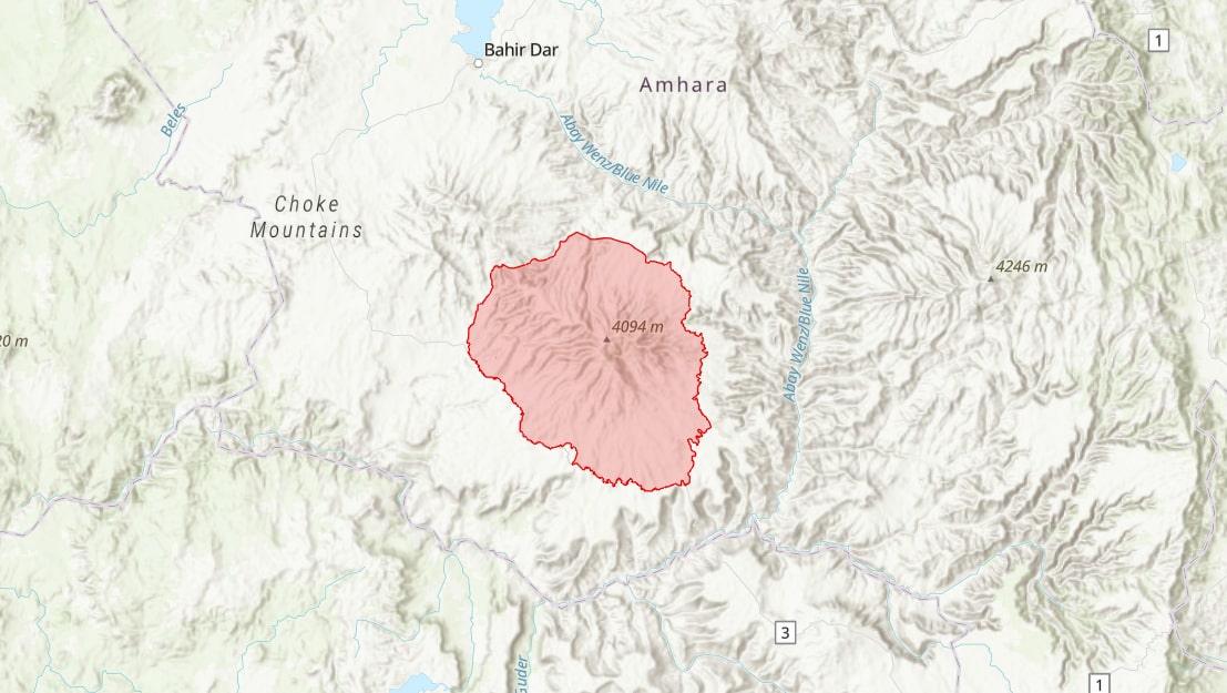
Central co-ordinates: 10.75641 N, 37.74826 E
Area: 5578km²
Qualifying IPA Criteria
A(i)Site contains one or more globally threatened species
IPA assessment rationale
The Choke Mountains qualifies as an IPA under criterion A(i) due to the presence of eleven globally threatened species: Crepis achyrophoroides (EN), Poa chokensis (EN), Habenaria excelsa (EN), Thunbergia hirsuta (EN), Ceropegia loranthiflora (VU), Crepis tenerrima (VU), Disperis galerita (VU), Helichrysum hedbergianu (VU), Hyparrhenia tuberculata (VU), Ledebouria urceolata (VU) and Senecio farinaceus (VU). There are significant threats to these species and the wider landscape, principally due to agricultural expansion across the mountain range over the last three decades. The presence of several endemic species that are yet to be Red Listed is also significant as future assessments may lead to further threatened species being identified within the IPA.
Site description
The Choke Mountains IPA is situated in the Gojam floristic region and East and West Gojam zones of Amhara Regional State, in the northwestern highlands of Ethiopia (Haile, 2015). The IPA is located to the south-southeast of Lake Tana, with the towns of Bahir Dar to the northwest, and Debre Markos to the south. The IPA has been extensively degraded through agricultural expansion, resource exploitation and overgrazing, with agricultural fields found as high as 3,800 m (Simane et al., 2013), thus threatening the site's biodiversity. Given that the IPA supports many endemic and globally threatened plant species, some of which are only found in one or two other locations globally, further degradation poses significant threats to the site's floristic diversity.
The Choke Mountains are considered to be one of East Africa's 'water towers', serving as the headwaters of surrounding streams and rivers, including the Upper Abbay (Blue Nile) River, the largest tributary of the Nile (Teferi et al., 2010; Haile, 2015). Over 50 of the Abbay's tributaries originate from the Choke Mountain range, accounting for over 85% of the river's total flow (Alemneh et al., 2017; Gessesse et al., 2019). The Choke Mountains are also designated as an Important Bird Area (IBA) and Key Biodiversity Area (KBA).
Botanical significance
The Choke Mountains IPA is an important site for ten globally threatened, Ethiopian endemic species: Crepis achyrophoroides (EN), Habenaria excelsa (EN), Thunbergia hirsuta (EN), Ceropegia loranthiflora (VU), Crepis tenerrima (VU), Disperis galerita (VU), Helichrysum hedbergianum (VU), Hyparrhenia tuberculata (VU), Ledebouria urceolata (VU) and Senecio farinaceus (VU). While none of these species are endemic to this site specifically, three (Crepis achyrophoroides, Crepis tenerrima and Thunbergia hirsuta) are only known to occur in one other locality and are thus particularly vulnerable to further habitat degradation and fragmentation. In addition, the IPA supports the near-endemic, globally threatened species, Poa chokensis (EN), which is only known to occur at one other site, on Mount Elgon in Uganda.
An additional 38 Ethiopian endemics or near-endemics are known to be present within the IPA, based on georeferenced herbarium records. Most of these species are yet to be Red Listed, so further threatened species may be added in due course. One notable species that has been assessed and occurs in the IPA is the important medicinal herb, Echinops kebericho (NT). Other extant species include Aloe trigonantha (LC), Thesium matteii (DD) and Vachellia (Acacia) negrii (NT). In addition to these 38 species, Fetene et al. (2014) report another endemic in the Choke Mountains, namely Euryops antinorii. This species is apparently locally abundant, although there are no known supporting herbarium vouchers to confirm its presence in the IPA.
Habitat and geology
The IPA is mountainous with deep incised valleys and gorges (Teme et al., 2018; Key Biodiversity Areas, 2020). Mount Choke is the highest peak at just over 4,070 m. Land cover types include grasslands, shrublands, agricultural land, urban areas and wetlands (Fetene et al., 2014; Simane et al., 2014). The Choke Mountains are a source of over 23 major rivers, including the Muga, Chemoga, Abeya and Techma rivers, and 273 streams that discharge into the Abbay (Blue Nile) River (Fetene et al., 2014; Haile, 2015). Agriculture within the IPA is largely mixed crop and livestock subsistence farming (Simane et al., 2014). In the highlands, the main crops are barley, potato, fava bean and engido (Avena spp.), whereas maize, tef and wheat are more common at mid elevations (Simane et al., 2013).
Historically, the Choke Mountains were covered by a mosaic of dense, dry Afromontane forest, shrubland and grassland and patches of Ericaceous bushland (Friis et al., 2010; Teferi et al., 2010; Fetene et al., 2014). However, due to extensive agricultural expansion, the mountain range has been largely cleared of its natural forests (Kerato, 2014). The summit is characterised by Afroalpine and sub-Afroalpine vegetation, dominated by shrublands, grasslands and moist moorlands (Simane et al., 2013; Haile, 2015). Moist moorlands are sparsely covered with Lobelia rhynchopetalum, Alchemilla spp., Festuca spp. and other grasses (Teferi et al., 2010; Simane et al., 2013; Fetene et al., 2014). Fetene et al. (2014) found Euryops antinorii to be the most dominant herbaceous plant, often utilised by local communities for fuel, in spite of the aforementioned absence of herbarium vouchers for this species in the IPA. Additionally, Subularia monticola is commonly found along streams (Fetene et al., 2014). Haile (2015) reported 142 species across 103 genera and 40 families within this Afroalpine zone.
The IPA has very little natural woody plant cover remaining; Erica arborea (LC) and Hypericum revolutum (LC) are only found in patches (Simane et al., 2013; Simane et al., 2014). Bamboo (Oldeania alpina) occurs naturally in sparse patches and homestead plantations (Teferi et al., 2010; Simane et al., 2014), and exotic Eucalyptus globulus plantations are extensive throughout the IPA, which many communities rely on as a source of income (Teferi et al., 2010; Simane et al., 2014). Adane et al. (2015) also reported the presence of the globally threatened but widespread timber species, Prunus africana (VU). Four community types are thought to exist across the Choke Mountain range (Kerato, 2014). The lower elevations and surrounding areas (c. 1050 m to 2800 m) are characterised by two dominant tree species (Vachellia (Acacia) abyssinica and Croton macrostachyus) and one dominant shrub species (Grewia bicolor). Between c. 1400 m and 1700 m, Tamarindus indica, Albizia isenbergiana and Dichrostachys cinerea are the three characteristic species. A third community is the Phytolacca dodecandra – Dombeya torrida community in the mid elevations of the IPA, comprising a variety of woody species, many of which match those reported by Simane et al. (2013). Above c. 3500 m, an Erica arborea community is found, where Erica arborea, Hypericum quartinianum, Helichrysum citrispinum and Euryops pinifolius predominate (Kerato, 2014; Haile, 2015).
The IPA has six major agroecosystem (AES) zones (Simane et al., 2013). Agricultural activity is intense in AES 1 to 4. The Lowland and Abbay valley (AES 1), found in the northern region of the IPA and surrounding areas, is characterised by rugged terrain and extensive land degradation. Bamboo (Oxytenanthera abyssinica) and Acacia spp. are especially common (Simane et al., 2013). The Midland plains with black soil (AES 2) are found on the IPA's eastern slopes, towards the towns of Felege Birhan, Bichena, and Dejen. Prunus africana, Hagenia abyssinica, Erythrina brucei and Oldeania alpina occur sparsely within this AES. The Midland plains with brown soil (AES 3) are found in the southern extremes of the IPA and the Midland sloping lands (AES 4) are located on its southern slopes, the latter dominated by Eucalyptus plantations. The Hilly and Mountainous highlands (AES 5) dominate the upper regions of the IPA (2800-3800 m), with dominant native species including Juniperus procera, Erica arborea, Hagenia abyssinica, Hypericum revolutum and Olea europaea. The summit of the IPA (>3800 m) - an important region for biodiversity and soil/water retention - is classed as Afro Alpine (AES 6), where the major natural habitat is moist moorlands.
The Choke Mountain range is comprised of inactive shield volcanoes, formed across the Oligocene and Miocene epochs, surrounded by flood basalts (Habtamu, 2003; Teferi et al., 2010; Fetene et al., 2014; Adane et al., 2015; Haile, 2015). The IPA consists of around ten main deposits, predominantly different varieties of basalt (Blond et al., 2015). Soils are principally haplic alisols, eutric vertsiols, eutric Leptosols, and luvisols (Teferi et al., 2010; Simane et al., 2013; Blond et al., 2015). Soils at higher elevations are typically greyish brown, derived from shield volcano lavas, whereas soils at lower elevations are reddish brown, derived from flood basalts (Simane et al., 2010; Blond et al., 2015).
The climate of the IPA falls within the Wurch (cool highlands, > 3000 m), Dega (cool highlands, 2500-3000 m), and Woina-Dega (temperate highlands, 1500-2500 m) agroclimatic zones (Haile, 2015). There is thus considerable local variability in rainfall and temperature associated with the IPA's topographic gradients (Zaitchik et al., 2012): the summit of the mountain has a mean annual temperature of 7.5 – 8C, while the base of the mountain range has a mean annual temperature of approximately 25 – 30.5C (Teferi et al., 2010; Simane et al., 2013; Kerato, 2014). Rainfall is unimodal, with the wet season occurring from May to October (Haile, 2015). Rainfall ranges from 600 mm to 2000 mm per year (Teferi et al., 2010; Adane et al., 2015), although the IPA's western slopes tend to be wetter than its eastern slopes (Simane et al., 2013).
Conservation issues
There is currently no formal site protection or management plan in place within the IPA. The Choke Mountains were designated as an Important Bird Area (IBA) in 1996 under criteria A1 and A3, based on the occurrence of 16 resident species (BirdLife, 2021). A 1995 survey reported 49 bird species, including the Abyssinian Longclaw (Macronyx flavicollis, NT) (BirdLife, 2021). The Choke Mountains Key Biodiversity Area (KBA) was last assessed in 2011 and is a priority for reassessment (Key Biodiversity Areas, 2020).
Some patches of ericaceous forest near the summit have been traditionally conserved by the local community since 1987 (Fetene et al., 2014). These patches are referred to as Aba Jime Forest, named after the monk who established their conservation (Fetene et al., 2014). Local priests also contribute to the protection of the forest by condemning forest clearance at Sunday Church programs (Fetene et al., 2014). However, conversion of montane vegetation to agricultural fields and pasture land continues (Fetene et al., 2014), in part due to increasing population pressures, which have contributed to cultivation, tree cover loss and natural habitat degradation at altitudes as high as 3,800 m (Simane et al., 2013). Forest was rapidly converted to cropland and pastureland, and was over-exploited for fuelwood and construction material, after the Derg Regime ceased in 1991 (Fetene et al., 2014). The remaining areas of intact forest are used as shade during drought periods and the vegetation is used to fatten livestock (Fetene et al., 2014). Areas that once contained dense stands of Hypericum revolutum are now bare, and the once abundant Ericaceous bushland is now largely fragmented (Fetene et al., 2014). Riverine trees within the Chemoga watershed declined by 79% between 1957 and 1998, largely due to cultivation (Bewket, 2002).
The Choke Mountain range is thus one of the most intensively cultivated areas in Ethiopia. Between 1986 and 2011, cropland increased by 206%, while forested areas decreased by 79%, grasslands by 40%, and shrublands by 17% (Fetene et al., 2014; Gessesse et al., 2019). Cultivated areas extend from the Abbay River gorge up to the summit of the Choke Mountains (Simane et al., 2013). Declining productivity of agricultural fields, due to unsustainable methods and soil degradation, has contributed to further agricultural expansion (Simane et al., 2012; Gessesse et al., 2019). Additionally, soil acidity is increasing and is likely causing a decline in crop yields (Simane et al., 2013). Erosion rates are also high, with soil erosion prominent across much of the mountain range (Simane et al., 2013; Blond et al., 2015; Gessesse et al., 2019). This is likely exacerbated by traditional crisscross ox-drawn tillage (Simane et al., 2013). It has also been estimated that agricultural land from the highland areas in the IPA area are a major sediment source into the Abbay River (Bewket & Teferi, 2009; Blond et al., 2015).
Additional threats include land conversion for Eucalyptus plantations and diversion of streams for irrigation (Simane et al., 2012; Fetene et al., 2014; Haile, 2015; Alemneh et al., 2017; Gessesse et al., 2019). Climate change is also thought to be a contributing factor, with an increase in regional temperatures and extreme rain events within the last 20 years (Simane et al., 2012). Studies have also shown that agricultural expansion in Choke is linked with a declining abundance of bird species and falling aquatic macro-invertebrate diversity (Alemneh et al., 2017; Takele & Afework, 2018).
Ecosystem services
The main land use within the IPA is agriculture, upon which the the majority of local communities depend (Zaitchik et al., 2012). Natural habitats are increasingly utilised for pasture and as a source of raw materials, such as fuel and timber. Honey production also occurs in remnant forest patches (Kerato, 2014). However, the IPA may have potential as a community-based eco- and agro-tourism site (Kerato, 2014; Aseres, 2015). Current tourism activities include trekking, wildlife viewing, swimming, boating and cultural eco-tourism (Aseres, 2015; Aseres & Simane, 2016). However, Aseres & Simane (2016) report that the IPA is generally lacking in tourism infrastructure, despite its great potential. Potential future tourism sites include the Aba Jime Forest, caves such as Mollale cave, and historic monasteries and churches (Aseres, 2015; Debre Markos University, 2017).
The Choke Mountains are also reported to support at least 24 mammal species, most notably the Leopard (Panthera pardus, VU) and nine rodent species, 50 bird species and three amphibian species (Takele & Afework, 2018; Teme et al., 2018). Additionally, the rare endemic rodents, Nilopegamys plumbeus and Otomys cheesmani, were described from the Choke Mountains, although they are now thought to be extremely rare and possibly extinct (Kostin et al., 2020).
Site assessor(s)
Eden House, Royal Botanic Gardens, Kew
Joe Langley, Royal Botanic Gardens, Kew
Iain Darbyshire, Royal Botanic Gardens, Kew
Sebsebe Demissew, Addis Ababa University
Sileshi Nemomissa, Addis Ababa University
Ermias Lulekal, Addis Ababa University
IPA criterion A species
| Species | Qualifying sub-criterion | ≥ 1% of global population | ≥ 5% of national population | 1 of 5 best sites nationally | Entire global population | Socio-economically important | Abundance at site |
|---|---|---|---|---|---|---|---|
| Crepis achyrophoroides Vatke | A(i) |  |
|
|
 |
|
Unknown |
| Crepis tenerrima Sch.Bip. ex Oliv. | A(i) | |
|
|
|
|
Unknown |
| Poa chokensis S.M.Phillips | A(i) | |
|
|
|
|
Unknown |
| Disperis galerita Rchb.f. | A(i) | |
|
|
|
|
Unknown |
| Habenaria excelsa S.Thomas & P.J.Cribb | A(i) | |
|
|
|
|
Unknown |
| Senecio farinaceus Sch.Bip. ex A.Rich. | A(i) | |
|
|
|
|
Unknown |
| Ledebouria urceolata Stedje | A(i) | |
|
|
|
|
Unknown |
| Hyparrhenia tuberculata Clayton | A(i) | |
|
|
|
|
Unknown |
| Thunbergia hirsuta T.Anderson | A(i) | |
|
|
|
|
Unknown |
| Ceropegia loranthiflora K.Schum. | A(i) | |
|
|
|
|
Unknown |
| Helichrysum hedbergianum Mesfin & T.Reilly | A(i) | |
|
|
|
|
Unknown |
| Prunus africana (Hook.f.) Kalkman | A(i) | |
|
|
|
|
Unknown |
Crepis achyrophoroides Vatke
Qualifying sub-criterion:
A(i)
≥ 1% of global population:
≥ 5% of national population:
1 of 5 best sites nationally:
Entire global population:
Socio-economically important:
Abundance at site:
Unknown
Crepis tenerrima Sch.Bip. ex Oliv.
Qualifying sub-criterion:
A(i)
≥ 1% of global population:
≥ 5% of national population:
1 of 5 best sites nationally:
Entire global population:
Socio-economically important:
Abundance at site:
Unknown
Poa chokensis S.M.Phillips
Qualifying sub-criterion:
A(i)
≥ 1% of global population:
≥ 5% of national population:
1 of 5 best sites nationally:
Entire global population:
Socio-economically important:
Abundance at site:
Unknown
Disperis galerita Rchb.f.
Qualifying sub-criterion:
A(i)
≥ 1% of global population:
≥ 5% of national population:
1 of 5 best sites nationally:
Entire global population:
Socio-economically important:
Abundance at site:
Unknown
Habenaria excelsa S.Thomas & P.J.Cribb
Qualifying sub-criterion:
A(i)
≥ 1% of global population:
≥ 5% of national population:
1 of 5 best sites nationally:
Entire global population:
Socio-economically important:
Abundance at site:
Unknown
Senecio farinaceus Sch.Bip. ex A.Rich.
Qualifying sub-criterion:
A(i)
≥ 1% of global population:
≥ 5% of national population:
1 of 5 best sites nationally:
Entire global population:
Socio-economically important:
Abundance at site:
Unknown
Ledebouria urceolata Stedje
Qualifying sub-criterion:
A(i)
≥ 1% of global population:
≥ 5% of national population:
1 of 5 best sites nationally:
Entire global population:
Socio-economically important:
Abundance at site:
Unknown
Hyparrhenia tuberculata Clayton
Qualifying sub-criterion:
A(i)
≥ 1% of global population:
≥ 5% of national population:
1 of 5 best sites nationally:
Entire global population:
Socio-economically important:
Abundance at site:
Unknown
Thunbergia hirsuta T.Anderson
Qualifying sub-criterion:
A(i)
≥ 1% of global population:
≥ 5% of national population:
1 of 5 best sites nationally:
Entire global population:
Socio-economically important:
Abundance at site:
Unknown
Ceropegia loranthiflora K.Schum.
Qualifying sub-criterion:
A(i)
≥ 1% of global population:
≥ 5% of national population:
1 of 5 best sites nationally:
Entire global population:
Socio-economically important:
Abundance at site:
Unknown
Helichrysum hedbergianum Mesfin & T.Reilly
Qualifying sub-criterion:
A(i)
≥ 1% of global population:
≥ 5% of national population:
1 of 5 best sites nationally:
Entire global population:
Socio-economically important:
Abundance at site:
Unknown
Prunus africana (Hook.f.) Kalkman
Qualifying sub-criterion:
A(i)
≥ 1% of global population:
≥ 5% of national population:
1 of 5 best sites nationally:
Entire global population:
Socio-economically important:
Abundance at site:
Unknown
General site habitats
| General site habitat | Percent coverage | Importance |
|---|---|---|
| Forest - Subtropical/Tropical Moist Montane Forest | |
Minor |
| Shrubland - Subtropical/Tropical High Altitude Shrubland | |
Major |
| Grassland - Subtropical/Tropical High Altitude Grassland | |
Major |
| Wetlands (inland) - Permanent Rivers, Streams, Creeks [includes waterfalls] | |
Major |
| Wetlands (inland) - Alpine Wetlands [includes temporary waters from snowmelt] | |
Major |
| Rocky Areas - Rocky Areas [e.g. inland cliffs, mountain peaks] | |
Major |
| Artificial - Terrestrial - Arable Land | |
Major |
| Artificial - Terrestrial - Pastureland | |
Major |
| Artificial - Terrestrial - Plantations | |
Major |
| Artificial - Terrestrial - Urban Areas | |
Minor |
| Artificial - Terrestrial - Subtropical/Tropical Heavily Degraded Former Forest | |
Major |
Forest - Subtropical/Tropical Moist Montane Forest
Percent coverage:
Importance:
Minor
Shrubland - Subtropical/Tropical High Altitude Shrubland
Percent coverage:
Importance:
Major
Grassland - Subtropical/Tropical High Altitude Grassland
Percent coverage:
Importance:
Major
Wetlands (inland) - Permanent Rivers, Streams, Creeks [includes waterfalls]
Percent coverage:
Importance:
Major
Wetlands (inland) - Alpine Wetlands [includes temporary waters from snowmelt]
Percent coverage:
Importance:
Major
Rocky Areas - Rocky Areas [e.g. inland cliffs, mountain peaks]
Percent coverage:
Importance:
Major
Artificial - Terrestrial - Arable Land
Percent coverage:
Importance:
Major
Artificial - Terrestrial - Pastureland
Percent coverage:
Importance:
Major
Artificial - Terrestrial - Plantations
Percent coverage:
Importance:
Major
Artificial - Terrestrial - Urban Areas
Percent coverage:
Importance:
Minor
Artificial - Terrestrial - Subtropical/Tropical Heavily Degraded Former Forest
Percent coverage:
Importance:
Major
Land use types
| Land use type | Percent coverage | Importance |
|---|---|---|
| Agriculture (arable) | |
Major |
| Agriculture (pastoral) | |
Unknown |
| Tourism / Recreation | |
Minor |
| Forestry | |
Minor |
| Residential / urban development | |
Minor |
| Harvesting of wild resources | |
Minor |
Agriculture (arable)
Percent coverage:
Importance:
Major
Agriculture (pastoral)
Percent coverage:
Importance:
Unknown
Tourism / Recreation
Percent coverage:
Importance:
Minor
Forestry
Percent coverage:
Importance:
Minor
Residential / urban development
Percent coverage:
Importance:
Minor
Harvesting of wild resources
Percent coverage:
Importance:
Minor
Threats
| Threat | Severity | Timing |
|---|---|---|
| Residential & commercial development - Housing & urban areas | Medium | Ongoing - trend unknown |
| Agriculture & aquaculture - Annual & perennial non-timber crops - Shifting agriculture | High | Ongoing - increasing |
| Agriculture & aquaculture - Wood & pulp plantations - Small-holder plantations | High | Ongoing - increasing |
| Agriculture & aquaculture - Livestock farming & ranching - Small-holder grazing, ranching or farming | High | Ongoing - trend unknown |
| Biological resource use - Logging & wood harvesting | High | Ongoing - trend unknown |
| Climate change & severe weather | Unknown | Ongoing - trend unknown |
| Agriculture & aquaculture - Annual & perennial non-timber crops - Small-holder farming | High | Ongoing - increasing |
Residential & commercial development - Housing & urban areas
Severity:
Medium
Timing:
Ongoing - trend unknown
Agriculture & aquaculture - Annual & perennial non-timber crops - Shifting agriculture
Severity:
High
Timing:
Ongoing - increasing
Agriculture & aquaculture - Wood & pulp plantations - Small-holder plantations
Severity:
High
Timing:
Ongoing - increasing
Agriculture & aquaculture - Livestock farming & ranching - Small-holder grazing, ranching or farming
Severity:
High
Timing:
Ongoing - trend unknown
Biological resource use - Logging & wood harvesting
Severity:
High
Timing:
Ongoing - trend unknown
Climate change & severe weather
Severity:
Unknown
Timing:
Ongoing - trend unknown
Agriculture & aquaculture - Annual & perennial non-timber crops - Small-holder farming
Severity:
High
Timing:
Ongoing - increasing
Protected areas
| Protected area name | Protected area type | Relationship with IPA | Areal overlap |
|---|---|---|---|
| Aba Jime Forest | Community conservation area | IPA encompasses protected/conservation area | |
Aba Jime Forest
Protected area type:
Community conservation area
Relationship with IPA:
IPA encompasses protected/conservation area
Areal overlap:
Conservation designation
| Designation name | Protected area | Relationship with IPA | Areal overlap |
|---|---|---|---|
| Choke Mountains IBA | Important Bird Area | IPA encompasses protected/conservation area | 1085 |
| Choke Mountains KBA | Key Biodiversity Area | IPA encompasses protected/conservation area | 1085 |
Choke Mountains IBA
Protected area:
Important Bird Area
Relationship with IPA:
IPA encompasses protected/conservation area
Areal overlap:
1085
Choke Mountains KBA
Protected area:
Key Biodiversity Area
Relationship with IPA:
IPA encompasses protected/conservation area
Areal overlap:
1085
Management type
| Management type | Description | Year started | Year finished |
|---|---|---|---|
| No management plan in place | |
|
No management plan in place
Year started:
Year finished:
Bibliography
Atlas of the Potential Vegetation of Ethiopia.
Ethiopian vegetation types, climate and topography
Plant Diversity, Vol 42, page(s) 302-311
The status of food availability in the face of climate change and variability in Choke Mountain Watersheds, Central Ethiopia
Journal of Development and Agricultural Economics, Vol 7, page(s) 358-372
Modelling the impact of highland settlements on ecological disturbance of streams in Choke Mountain Catchment: Macroinvertebrate assemblages and water quality
Ecological Indicator, Vol 73, page(s) 452-459
Assessment of the Potentials Tourism Resources of Choke Mountain and its Environs, Ethiopia.
Journal of Tourism & Hospitality, Vol 4, page(s) 164
Potentials of Community Participation in Community-based Ecotourism Development: Perspective of Sustainable Local Development a Case of Choke Mountain, Northern Ethiopia
Journal of Hotel & Business Management, Vol 4, page(s) 1
Development of Community-Based Ecotourism, A Case of Choke Mountain and Its Environs, Ethiopia: Challenges and Opportunities
Journal of Tourism, Hospitality and Sports, Vol 16
Pleistocene colonization of afro-alpine ‘sky islands’ by the arctic-alpine Arabis alpina.
Heredity, Vol 99, page(s) 133-142
Land Cover Dynamics Since the 1950s in Chemonga Watershed, Blue Nile Basin, Ethiopia
Mountain Research and Development, Vol 22, page(s) 263-269
Assessment of soil erosion hazard and prioritization for treatment at the watershed level: Case study in the Chemoga watershed, Blue Nile basin, Ethiopia
Land Degradation & Development, Vol 20, page(s) 609-622
Weathering of the Ethiopian volcanic province: A new weathering index to characterize and compare soils
American Mineralogist, Vol 100, page(s) 2518-2532
Choke Mountain
Land Use Dynamics and Base and Peak Flow Responses in the Choke Mountain Range, Upper Blue Nile Basin, Ethiopia
International Journal of River Basin management
Important Bird Areas Factsheet: Choke Mountains
Effects of Landuse and Land Cover Changes on the Extent and Distribution of Afroalpine Vegetation of Northern Western Ethiopia: The Case of Choke Mountains
Research Journal of Environmental Sciences, Vol 8, page(s) 17-28
Lord, Zega and peasant in Eastern Gojjam. MA Thesis
Ecological Study of the Vegetation in Choke-Koso Ber Mountain Range, Northwest Ethiopia. PhD Thesis
Utilization of Natural Resources and Conflict? The Case of Choke Mountain Watersheds, East Gojjam, Ethiopia
International Journal of Research in Geography, Vol 5, page(s) 13-21
Distribution of the Woody Vegetation along the Altitudinal range from Abay (Blue Nile) Gorge to Choke Mountain, East Gojjam Zone, Amhara National Regional State, Northwest Ethiopia. MSc Thesis
Key Biodiversity Areas factsheet: Choke mountains
Rodents of Choke Mountain and surrounding areas (Ethiopia): the Blue Nile gorge as a strong biogeographic barrier
Journal of Vertebrate Biology, Vol 69, page(s) 20016
Four New Grasses from North East Tropical Africa
Kew Bulletin, Vol 41, page(s) 1027-1030
Agroecosystem Analysis of the Choke Mountain Watersheds, Ethiopia
Sustainability, Vol 5, page(s) 592-616
Agroecosystem specific climate vulnerability analysis: application of the livelihood vulnerability index to a tropical highland region
Mitigation and Adaptation Strategies for Global Change, Vol 21, page(s) 39-65
A preliminary study on species composition, relative abundance and distribution of bird species in Choke Mountains, East Gojjam, Ethiopia
International Journal of Biodiversity and Conservation, Vol 10, page(s) 517-526
The use of remote sensing to quantify wetland loss in the Choke Mountain range, Upper Blue Nile basin, Ethiopia
Hydrology and Earth System Sciences, Vol 14, page(s) 2415-2428
Assessment of the wildlife and ecosystem status of Choke Mountain, North Western Ethiopia
Biological Diversity and Conservation, Vol 11, page(s) 125-132
Building Climate Resilience in the Blue Nile/Abay Highlands: A Role for Earth System Sciences
International Journal of Environmental Research and Public Health, Vol 9, page(s) 435-461


Recommended citation
Eden House, Joe Langley, Iain Darbyshire, Sebsebe Demissew, Sileshi Nemomissa, Ermias Lulekal (2024) Tropical Important Plant Areas Explorer: Choke Mountains (Ethiopia). https://tipas.kew.org/site/choke-mountains/ (Accessed on 27/07/2024)