Country: Ethiopia
Administrative region: Southern Nations, Nationalities, and Peoples' (Regional State)
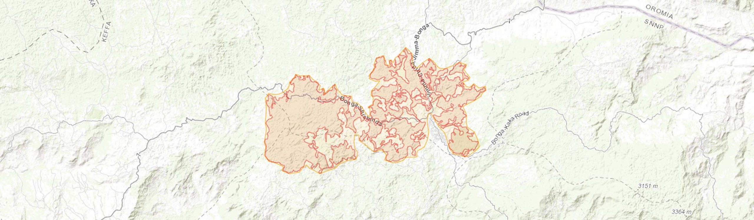
Central co-ordinates: 7.31083 N, 36.22979 E
Area: 311km²
Qualifying IPA Criteria
A(i)Site contains one or more globally threatened species
IPA assessment rationale
The forests of Bonga and Wushwush qualify as an IPA under criterion A(i) due to the presence of six globally threatened species for which this IPA is a site of primary importance and likely to be amongst the most secure sites: Crotalaria polhillii (EN), Dorstenia soerensenii (EN), Streptocarpus phaeotrichus (EN), Scadoxus nutans (VU), Sesbania melanocaulis (VU), and Coffea arabica (EN). These species are threatened by habitat degradation and encroachment.
Site description
The Forests of Bonga and Wushwush are located within the southwestern highlands of Ethiopia, in the Kefa floristic region and within the Southern Nations, Nationalities, and Peoples’ Regional State. The southwest highlands in Ethiopia are dominated by Moist Evergreen Afromontane Forest (Friis et al., 2010), the primary centre of diversity for the threatened Coffea arabica L. (Labouisse et al., 2008). Large areas of the forest are used for coffee production using shade-cropping agroforestry techniques. These forests support an interesting plant diversity, including several species that are endemic to southwest Ethiopia.
The topography of this site and the surrounding areas are characterised by undulating hills, mountainous terrain, and river valleys (NABU, 2017). Surrounding land type uses form a complex mosaic of disturbed and undisturbed forest, river systems, farmland, and settlements.
The forests of Bonga and Wushwush are partially encompassed by the UNESCO-MAB Kafa Biosphere Reserve core and buffer zonal regions, whilst the areas not within the reserve come under the Bonga National Forest Priority Area (NFPA). As well as being a NFPA, Bonga forest is designated as an Important Bird Area (IBA) and Key Biodiversity Area (KBA) (Key Biodiversity Areas Partnership, 2020; BirdLife, 2021).
Bordering this IPA are the towns of Bonga to the southeast (the administrative centre of the Kafa Zone), and Wushwush to the northwest. The town of Bonga was historically important to the ancient Kingdom of Kafa as a trade route. The forests contain ruins from the Kingdom which have now become places of cultural importance (Schmitt, 2006; Kafa Biosphere Reserve, 2009).
Botanical significance
Bonga and Wushwush are home to some of the best examples of remaining Moist Evergreen Montane forest in Ethiopia, which constitutes an important part of the Eastern Afromontane Biodiversity Hotspot (Friis et al., 2010; NABU, 2017). The montane rainforests of Ethiopia are particularly noteworthy of being the place of origin and an important gene pool for the endangered wild coffee, Coffea arabica (Kufa & Burkhardt, 2011; NABU, 2014). Wild and cultivated Coffea arabica are found extensively throughout this IPA (Kufa & Burkhardt, 2011).
Forested riverine fringes within the IPA are particularly important as they are mostly intact and have a higher diversity than other parts of the forest, including supporting some of the rare and threatened species. Of particular note are three threatened forest species endemic to Ethiopia for which this site is of global importance: Dorstenia soerensenii Friis (EN), Streptocarpus phaeotrichus Chiov. ex B.L.Burtt (EN) and Scadoxus nutans (Friis & I.Bjornstad) Friis & Nordal (VU). The forests of Bonga and Wushwush are also amongst the most important known locations for the near threatened Ethiopian endemic Barleria baluganii Ensermu. Two other threatened endemic species are noted from this IPA: Crotalaria polhillii Thulin (EN) which occurs in natural swampy grasslands, and Sesbania melanocaulis Bidgood & Friis (VU) which favours forest clearances. These species are each known from only a few locations and limited herbarium specimens. Through careful agroforestry management, and ideally the establishment of conservation zones along rivers, the Bonga-Wushwush forests should remain a site of critical importance for the rare and threatened species and plant diversity they contain.
Widespread but globally threatened timber species, Ocotea kenyensis (Chiov.) Robyns & R.Wilczek (VU) and Prunus africana (Hook.f.) Kalkman (VU) are present within the IPA. The main threat to P. africana comes from unsustainable harvesting of the bark for medicinal purposes (World Conservation Monitoring Centre, 1998; Jimu, 2011). However, the bark is not currently utilised within this IPA (Schmitt, 2006).
Habitat and geology
The topology of Bonga, Wushwush and the surrounding areas consists of undulating hills and mountainous terrain, dissected by rivers and streams (Schmitt et al., 2010). The area is characterised by Moist Evergreen Afromontane forest (Friis et al., 2010). Tree species of ecological importance include Pouteria adolfi-friedericii (Engl.) A.Meeuse, Olea welwitschii (Knobl.) Gilg & G.Schellenb., Allophylus abyssinicus (Hochst.) Radlk., Syzygium guineense DC., Vepris dainellii (Pic.Serm.) Kokwaro, Galiniera saxifraga (A.Rich.) Bridson, Dracaena steudneri Engl., and the tree fern Cyathea manniana Hook. (Schmitt, 2006; Nune, 2008). Ground vegetation includes Isoglossa punctata (Vahl) Brummitt & J.R.I.Wood, Centella asiatica (L.) Urb., Hypoestes forskaolii (Vahl) R.Br., Impatiens tinctoria A.Rich., and Crassocephalum macropappus S.Moore, together with numerous fern species (Nune, 2008). This IPA also contains bamboo thickets dominated by Oldeania alpina (K.Schum.) Stapleton (formerly Arundinaria alpina), riverine forest patches, and wild Coffea arabica (NABU, 2014). Forestry plantations exist around Bonga town and near Wushwush, largely comprised of Eucalyptus and Cupressus spp. (Chernet, 2008).
The IPA core zone consists of dense undisturbed forest, varying degrees of disturbed and managed forest, and wetlands (rivers, streams, springs, and waterfalls). Disturbed forest refers to areas that have been affected by settlements and agricultural activities (Nune, 2008), including agroforestry for shade-cropping of coffee. The buffer zone and surrounding area consists of a mosaic of land type uses including small and sometimes isolated patches of undisturbed and disturbed forest, together with wetlands, farmland, plantations, and settlements (Schmitt, 2006).
This IPA lies on the Jimma volcanic (upper sequence) formation, consisting of Tertiary volcanic rocks (Tsige et al., 2017). The upper surface of the site is characterised by sandstone, limestone, and volcanic rock such as trachite, ignimbrite, rhyolite, and tuff with minor basalt intrusions (NABU, 2017; Tsige et al., 2017). Soils are dominantly dystric nitisols (sand-clay rich), slightly acidic with an average pH of ca. 5.6, and a high magnesium and low calcium content (Kufa, 2011; NABU, 2017). Cambisols and regosols also occur (Schmitt et al., 2010). These soils are rich in humus, well-draining, and have a good water-holding capacity and are therefore ideal for coffee production (Schmitt, 2006).
The hydrogeology of Bonga and the surrounding area is characterised by extensive aquifers (Tsige et al., 2017). Most rivers and streams are perennial. Springs are also frequent. Water catchments from the IPA are drained by three main rivers, the Gojeb, Dinchia, and Woshi (Bekele, 2003).
The climate of Bonga and the surrounding area is humid. Between 2003 and 2005, the mean humidity was measured at 80% (Schmitt, 2006). Rainfall is unimodal with the wet season running from May to September; the average annual rainfall ranges from approximately 1,700 mm in Bonga, to approximately 1,800 mm in Wushwush (Schmitt, 2006; Kufa, 2011). The mean annual temperature ranges from 18.5°C to 19°C (Schmitt, 2006).
Conservation issues
The forests of Bonga and Wushwush are partially protected within the UNESCO-MAB Kafa Biosphere Reserve, designated in 2010 (UNESCO, 2018). This Biosphere Reserve contains over half of the remaining montane forests in Ethiopia (UNESCO, 2018). The Biosphere Reserve is divided into zonal regions (core zone, candidate core zone, buffer zone, and transition zone); the forests of Bonga and Wushwush partially overlap with the candidate core and buffer zones. The reserve aims to protect areas of intact forest and to implement sustainable agroforestry management.
The IPA overlaps with the Bonga National Forest Priority Area (NFPA), Bonga Important Bird Area (IBA), and Key Biodiversity Area (KBA). The NFPA nominally protects the forest; however legislation is not enforced and little to no protection is provided against population growth and agricultural encroachment. The Bonga NFPA was first delimited in 1985 and then expanded in 2002 (Schmitt et al., 2010). The Bonga IBA was last surveyed in 1996 (BirdLife, 2021). The Bonga KBA was designated in 2001 based on the occurrence of Clarke’s Banana Frog (Afrixalus clarkei; VU, now EN), Afrixalus enseticola (VU), Shoa Forest Treefrog (Leptopelis ragazzii, VU), Dime Forest Treefrog (Leptopelis vannutellii; then VU, now LC), and Macmillan’s shrew (Crocidura macmillani; then VU, now NT). The only threatened plant species noted in the KBA assessment was Prunus africana (VU) (Key Biodiversity Areas, 2020).
Between 1995 and 2010, NGOs including Farm Africa and SOS Sahel initiated and ran participatory forest management (PFM) at Bonga (Gobeze et al., 2009). The main objectives were to establish new sustainable forest management and to increase income to the local community. Gobeze et al. (2009) found that PFM areas around Bonga had a higher income and healthy vegetation structure than non-PFM areas. However, since 2010 PFM in and around Bonga has continued without external support and a noticeable decline in satisfactory forest protection has taken place, with increased logging from non-PFM members (Tekalign et al., 2015).
Bonga forest is known to have decreased in size since the 1970s (BirdLife, 2021). Despite the partial protection provided by the Biosphere Reserve since 2010, the forest has continued to decline. This IPA has three major threats. Firstly, population increase is putting pressure on the natural resources of the forests, increasing demand for timber, fuel wood, and land (Schmitt, 2006). A major road runs through this IPA providing easy export of timber and non-timber products to towns and cities such as Jimma and Addis Ababa. Secondly, agricultural expansion and the prioritization of food and cash crops over natural forests has resulted in deforestation and fragmentation (Nune, 2008). Natural forest is burned and cleared for cultivation of food crops such as tef, maize, and enset (Kassahun & Bender, 2020). In addition, areas within the IPA are naturally steeply sloped with sandy soils making them prone to soil erosion and landslides (Nune, 2008; Tsige et al., 2017). Conversion of forest to arable land could increase soil erosion and the likelihood of landslides. In the past, landslides have caused damage to local residences, primary and secondary roads, and disrupted water pipelines (Tsige et al., 2017). Thirdly, the expansion and management of tea and coffee plantations by investors and local communities (Chernet, 2008). Large areas of Bonga and Wushwush forest are subject to wild coffee management (Schmitt, 2006). Bordering the IPA to the northeast is the Wushwush Tea Plantation, one of the largest in Ethiopia, which has expanded into the surrounding forest. Coffee plantations require shade therefore only the understorey of the forest is removed, whereas tea plantations require the forest land to be completely cleared (Nune, 2008). Although less destructive than tea plantations, the removal of understorey vegetation for coffee management negatively impacts globally threatened species such as Dorstenia soerensenii and Scadoxus nutans (Lulekal et al., in press; Darbyshire et al., in press).
Although significant areas of the IPA buffer zone are degraded, some may have potential for forest restoration and creation of corridors to better connect some of the more isolated forest patches in the future.
Ecosystem services
This site is an important source of firewood, lianas, timber (for house, furniture, and beehive construction), and non-timber products such as grasses for thatch, honey and associated products, i.e. “tej” honey wine, wax, and spices (Aframomum corrorima (A.Braun) P.C.M.Jansen and Piper capense L.f.) for the local communities (Schmitt, 2006; Nune, 2008). Through careful management, these products can all be harvested sustainably.
Many medicinal plants found within the forest are utilised by local communities including Hagenia abyssinica (Bruce) J.F.Gmel., Astropanax abyssinicus (Hochst. ex A.Rich.) Seem. (Schefflera abyssinica), Syzygium guineense DC., and Fagaropsis angolensis (Engl.) H.M.Gardner which are used to treat both human and animal diseases (Bekele, 2003; Berhan & Bekele, 2006). Bekele (2003) suggests that there may be many more untapped medicinal species.
The forests are important culturally and economically, with the majority of the local economy coming from wild coffee management and agricultural crop production; over 90% of livelihoods depend on subsistence farming within the wider UNESCO-MAB Kafa Biosphere Reserve (Kassahun & Bender, 2020). Subsistence hunting and grazing of livestock are also known to occur but the extent is unknown (Nune, 2008). This IPA is representative of the environmental and socio-economic conditions that face the Afromontane forests of Ethiopia (Schmitt, 2006).
River systems within the IPA provide social services such as drinking water for humans and livestock, washing, and fishing (Nune, 2008).
Tourism in the area is increasing. Waterfalls, ancient ruins, bird watching, and important plant species such as Coffea arabica attract tourists (Bekele, 2003). In 2015, a new National Coffee museum was opened in Bonga. There is therefore the potential to create an ecotourism economy.
The forests of Bonga and Wushwush have a rich fauna, with many mammals, amphibians, and over 100 bird species (Bekele, 2003). Fauna that have been recorded within the IPA include the Hooded Vulture (Necrosyrtes monachus, CR), Spotted Hyena (Crocuta Crocuta), Common Jackel (Canis aureus), African Civet (Civettictis civetta), African Pigmy Mouse (Mus Mahomet), Clarke’s Banana Frog (Afrixalus clarkei, EN), Afrixalus enseticola (VU), and, the Shoa Forest Treefrog (Leptopelis ragazzii, VU) (NABU, 2017; Key Biodiversity Areas Partnership, 2020). Lions have been recorded around Bonga historically but are not presently found (NABU, 2017).
Site assessor(s)
Eden House, Royal Botanic Gardens, Kew
Iain Darbyshire, Royal Botanic Gardens, Kew
Sebsebe Demissew, Addis Ababa University
Sileshi Nemomissa, Addis Ababa University
Ermias Lulekal, Addis Ababa University
Tesfaye Awas, Ethiopian Biodiversity Institute
Birhanu Belay Telake, Gullele Botanic Garden
IPA criterion A species
| Species | Qualifying sub-criterion | ≥ 1% of global population | ≥ 5% of national population | 1 of 5 best sites nationally | Entire global population | Socio-economically important | Abundance at site |
|---|---|---|---|---|---|---|---|
| Dorstenia soerensenii Friis | A(i) |  |
|
|
 |
|
|
| Scadoxus nutans (Friis & I.Björnstad) Friis & Nordal | A(i) | |
|
|
|
|
|
| Streptocarpus phaeotrichus B.L.Burtt | A(i) | |
|
|
|
|
|
| Sesbania melanocaulis Bidgood & Friis | A(i) | |
|
|
|
|
|
| Ocotea kenyensis (Chiov.) Robyns & R.Wilczek | A(i) | |
|
|
|
|
|
| Coffea arabica L. | A(i) | |
|
|
|
|
|
| Crotalaria polhillii Thulin | A(i) | |
|
|
|
|
|
| Prunus africana (Hook.f.) Kalkman | A(i) | |
|
|
|
|
Dorstenia soerensenii Friis
Qualifying sub-criterion:
A(i)
≥ 1% of global population:
≥ 5% of national population:
1 of 5 best sites nationally:
Entire global population:
Socio-economically important:
Abundance at site:
Scadoxus nutans (Friis & I.Björnstad) Friis & Nordal
Qualifying sub-criterion:
A(i)
≥ 1% of global population:
≥ 5% of national population:
1 of 5 best sites nationally:
Entire global population:
Socio-economically important:
Abundance at site:
Streptocarpus phaeotrichus B.L.Burtt
Qualifying sub-criterion:
A(i)
≥ 1% of global population:
≥ 5% of national population:
1 of 5 best sites nationally:
Entire global population:
Socio-economically important:
Abundance at site:
Sesbania melanocaulis Bidgood & Friis
Qualifying sub-criterion:
A(i)
≥ 1% of global population:
≥ 5% of national population:
1 of 5 best sites nationally:
Entire global population:
Socio-economically important:
Abundance at site:
Ocotea kenyensis (Chiov.) Robyns & R.Wilczek
Qualifying sub-criterion:
A(i)
≥ 1% of global population:
≥ 5% of national population:
1 of 5 best sites nationally:
Entire global population:
Socio-economically important:
Abundance at site:
Coffea arabica L.
Qualifying sub-criterion:
A(i)
≥ 1% of global population:
≥ 5% of national population:
1 of 5 best sites nationally:
Entire global population:
Socio-economically important:
Abundance at site:
Crotalaria polhillii Thulin
Qualifying sub-criterion:
A(i)
≥ 1% of global population:
≥ 5% of national population:
1 of 5 best sites nationally:
Entire global population:
Socio-economically important:
Abundance at site:
Prunus africana (Hook.f.) Kalkman
Qualifying sub-criterion:
A(i)
≥ 1% of global population:
≥ 5% of national population:
1 of 5 best sites nationally:
Entire global population:
Socio-economically important:
Abundance at site:
General site habitats
| General site habitat | Percent coverage | Importance |
|---|---|---|
| Forest - Subtropical/Tropical Moist Montane Forest | |
Major |
| Wetlands (inland) - Permanent Rivers, Streams, Creeks [includes waterfalls] | |
Major |
| Artificial - Terrestrial - Plantations | |
Minor |
| Artificial - Terrestrial - Arable Land | |
Minor |
| Artificial - Terrestrial - Subtropical/Tropical Heavily Degraded Former Forest | |
Minor |
Forest - Subtropical/Tropical Moist Montane Forest
Percent coverage:
Importance:
Major
Wetlands (inland) - Permanent Rivers, Streams, Creeks [includes waterfalls]
Percent coverage:
Importance:
Major
Artificial - Terrestrial - Plantations
Percent coverage:
Importance:
Minor
Artificial - Terrestrial - Arable Land
Percent coverage:
Importance:
Minor
Artificial - Terrestrial - Subtropical/Tropical Heavily Degraded Former Forest
Percent coverage:
Importance:
Minor
Land use types
| Land use type | Percent coverage | Importance |
|---|---|---|
| Nature conservation | |
Major |
| Forestry | |
Major |
| Harvesting of wild resources | |
Major |
| Agriculture (arable) | |
Minor |
| Agriculture (pastoral) | |
Minor |
| Tourism / Recreation | |
Minor |
| Residential / urban development | |
Minor |
Nature conservation
Percent coverage:
Importance:
Major
Forestry
Percent coverage:
Importance:
Major
Harvesting of wild resources
Percent coverage:
Importance:
Major
Agriculture (arable)
Percent coverage:
Importance:
Minor
Agriculture (pastoral)
Percent coverage:
Importance:
Minor
Tourism / Recreation
Percent coverage:
Importance:
Minor
Residential / urban development
Percent coverage:
Importance:
Minor
Threats
| Threat | Severity | Timing |
|---|---|---|
| Residential & commercial development - Housing & urban areas | Medium | Ongoing - increasing |
| Agriculture & aquaculture - Annual & perennial non-timber crops | High | Ongoing - increasing |
| Agriculture & aquaculture - Wood & pulp plantations | High | Ongoing - increasing |
| Biological resource use - Logging & wood harvesting | Medium | Ongoing - increasing |
| Agriculture & aquaculture - Livestock farming & ranching - Nomadic grazing | Low | Ongoing - trend unknown |
Residential & commercial development - Housing & urban areas
Severity:
Medium
Timing:
Ongoing - increasing
Agriculture & aquaculture - Annual & perennial non-timber crops
Severity:
High
Timing:
Ongoing - increasing
Agriculture & aquaculture - Wood & pulp plantations
Severity:
High
Timing:
Ongoing - increasing
Biological resource use - Logging & wood harvesting
Severity:
Medium
Timing:
Ongoing - increasing
Agriculture & aquaculture - Livestock farming & ranching - Nomadic grazing
Severity:
Low
Timing:
Ongoing - trend unknown
Protected areas
| Protected area name | Protected area type | Relationship with IPA | Areal overlap |
|---|---|---|---|
| UNESCO-MAB Kafa Biosphere Reserve | UNESCO Biosphere Reserve | protected/conservation area overlaps with IPA | |
| Bonga National Forest Priority Area | National Forest Priority Area | protected/conservation area overlaps with IPA | |
UNESCO-MAB Kafa Biosphere Reserve
Protected area type:
UNESCO Biosphere Reserve
Relationship with IPA:
protected/conservation area overlaps with IPA
Areal overlap:
Bonga National Forest Priority Area
Protected area type:
National Forest Priority Area
Relationship with IPA:
protected/conservation area overlaps with IPA
Areal overlap:
Conservation designation
| Designation name | Protected area | Relationship with IPA | Areal overlap |
|---|---|---|---|
| Bonga Forest | Important Bird Area | protected/conservation area overlaps with IPA | |
| Bonga Forest | Key Biodiversity Area | protected/conservation area overlaps with IPA | |
Bonga Forest
Protected area:
Important Bird Area
Relationship with IPA:
protected/conservation area overlaps with IPA
Areal overlap:
Bonga Forest
Protected area:
Key Biodiversity Area
Relationship with IPA:
protected/conservation area overlaps with IPA
Areal overlap:
Management type
| Management type | Description | Year started | Year finished |
|---|---|---|---|
| Protected Area management plan in place | The Kafa Biosphere Reserve management plan came into action with the designation of the site in 2010 and makes up part of the AfriMAB network (UNESCO’s Man and the Biosphere program) (UNESCO, 2018). The primary aim of the Biosphere Reserve is to promote sustainable development within the reserve, of which biodiversity conservation is a prerequisite. The initial management plan focused on implementation of the biosphere reserve, and future plans for environmental management, poverty alleviation, economic sectors, education and research (Kafa Biosphere Reserve Management Plan, 2009). The environmental management plan focused on the designation of zonal areas, each with a different focus. Core zones are the focus of long- and short-term monitoring; candidate core zones are comprised of conservation-worthy habitats that do not have statutory conservation status, to be assessed as designated core zones; buffer zones focus on participatory forest management; transition zones are highly disturbed areas due to anthropogenic influences, e.g. settlements, plantations, and agricultural land (Kafa Biosphere Reserve Management Plan, 2009). In 2017, a biodiversity baseline was established to aid future biodiversity conservation and monitoring (NABU, 2017). | 2010 | |
Protected Area management plan in place
The Kafa Biosphere Reserve management plan came into action with the designation of the site in 2010 and makes up part of the AfriMAB network (UNESCO’s Man and the Biosphere program) (UNESCO, 2018). The primary aim of the Biosphere Reserve is to promote sustainable development within the reserve, of which biodiversity conservation is a prerequisite. The initial management plan focused on implementation of the biosphere reserve, and future plans for environmental management, poverty alleviation, economic sectors, education and research (Kafa Biosphere Reserve Management Plan, 2009).
The environmental management plan focused on the designation of zonal areas, each with a different focus. Core zones are the focus of long- and short-term monitoring; candidate core zones are comprised of conservation-worthy habitats that do not have statutory conservation status, to be assessed as designated core zones; buffer zones focus on participatory forest management; transition zones are highly disturbed areas due to anthropogenic influences, e.g. settlements, plantations, and agricultural land (Kafa Biosphere Reserve Management Plan, 2009).
In 2017, a biodiversity baseline was established to aid future biodiversity conservation and monitoring (NABU, 2017).
Year started:
2010
Year finished:
Bibliography
Threats and Conservation Strategies for the African Cherry (Prunus Africana) in Its Natural Range- A Review.
Journal of Ecology and The Natural Environment, Vol 3, page(s) 118-130
Atlas of the Potential Vegetation of Ethiopia.
The Potential of Bonga Forest for Certification: A case study.
Population structure and spatial distribution of four woody medicinal plant species in Bonga Forest, Ethiopia.
Ethiopian Journal of Natural Resources, Vol 8(1), page(s) 19-38
Important Bird Areas: Bonga forest.
Land Resources and socio-economic report of Bonga, Boginda, Mankira and the surrounding areas in Kaffa Zone, SNNPRS, Ethiopia.
Kafa Biosphere Reserve: History and Culture.
Food Security in the Face of Climate Change at Kafa Biosphere Reserve, Ethiopia.
Key Biodiversity Areas: Bonga Forest.
Chemical properties of wild coffee forest soils in Ethiopia and management implications.
Agricultural Sciences, Vol 2(4), page(s) 443-450
Plant composition and growth of wild Coffea arabica: Implications for management and conservation of natural forest resources.
International Journal of Biodiversity and Conservation, Vol 3(4), page(s) 131-141
Current status of coffee (Coffea arabica L.) genetic resources in Ethiopia: implications for conservation.
Genetic Resources and Crop Evolution, Vol 55, page(s) 1079
Biodiversity under Climate Change: Community-Based Conservation, Management and Development Concepts for the Wild Coffee Forests.
NABU’s Biodiversity Assessment at the Kafa Biosphere Reserve, Ethiopia
Flora Biodiversity Assessment in Bonga, Boginda and Mankira Forest, Kafa, Ethiopia
Montane rainforest with wild Coffea arabica in the Bonga region (SW Ethiopia): plant diversity, wild coffee management and implications for conservation.
Floristic diversity in fragmented Afromontane rainforests: Altitudinal variation and conservation importance.
Applied Vegetation Science, Vol 13(3), page(s) 291-304
Geotechnical Conditions and Stability Analysis of Landlside Prine Area: A Case Study in Bonga Town, South-Western Ethiopia.
International Journal of Scinetific & Engineering Research, Vol 8(4), page(s) 239-248
Kafa Biosphere Reserve, Ethiopia.
Participatory forest management and its impacts on livelihoods and forest status: the case of Bonga forest in Ethiopia.
International Forestry Review, Vol 11(3), page(s) 346-358
Challenges for improving forest conditions and forest based livelihoods through participatory forest management around Bonga, southwestern Ethiopia.
International Forestry Review, Vol 17(3), page(s) 355-367
Kafa Biosphere Reserve Management Plan
Prunus africana. The IUCN Red List of Threatened Species 1998: e.T33631A9799059


Recommended citation
Eden House, Iain Darbyshire, Sebsebe Demissew, Sileshi Nemomissa, Ermias Lulekal, Tesfaye Awas, Birhanu Belay Telake (2024) Tropical Important Plant Areas Explorer: Bonga Forests (Ethiopia). https://tipas.kew.org/site/bonga-forests/ (Accessed on 27/07/2024)