Country: British Virgin Islands
Administrative region: Beef Island (Province)
Central co-ordinates: 18.44211 N, 64.52583 W
Area: 4.1km²
Qualifying IPA Criteria
A(i)Site contains one or more globally threatened species, A(iv)Site contains one or more range restricted endemic species that are potentially threatened, B(ii)Site contains an exceptional number of species of high conservation importance, C(iii)Site contains nationally threatened or restricted habitat or vegetation types, AND/OR habitats that have severely declined in extent nationally
IPA assessment rationale
This TIPA has three of the nationally threatened terrestrial habitats (Coastal shrubland, Mangroves and Dry salt flats), is botanically rich and contains two globally threatened species and a Puerto Rican Bank Range Restricted Endemic species.
Site description
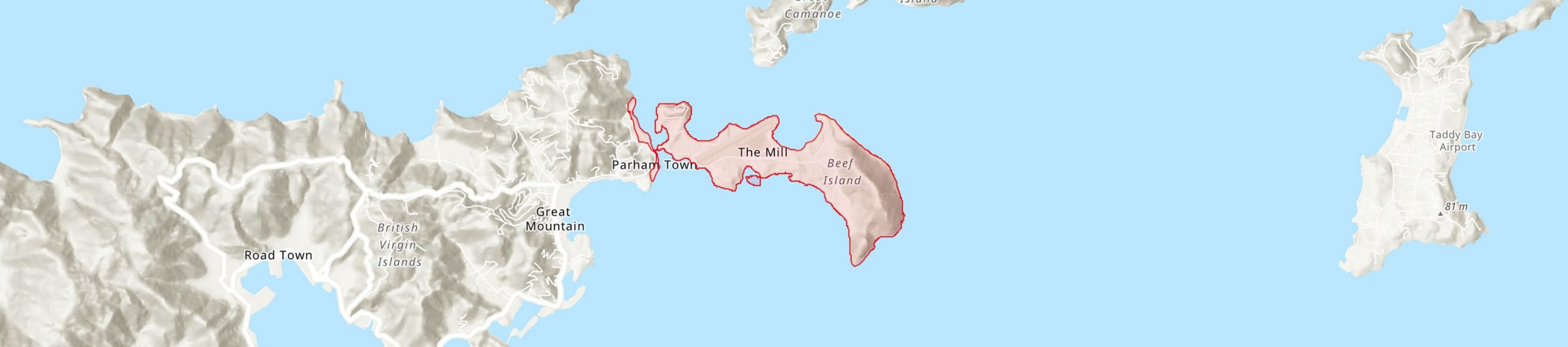
This TIPA encompasses all of Beef Island and the north-eastern mangroves of Tortola from Harris Pond to the outskirts of Chapel Hill.
Botanical significance
The TIPA is also a botanically rich site with a total of eight species of high conservation importance. Mount Alma is the highest point and has important populations of the globally threatened Puerto Rican Bank endemics Agave missionum (VU) and Malpighia woodburyana (VU). This is also one of the few sites in the BVI where the naturally occurring and Range Restricted Endemic (RRE) bromeliad Tillandsia x lineatispica occurs.
Habitat and geology
Beef Island has the third largest area (0.5%) of Dry salt flats in the BVI after Anegada and Tortola. Along the coast of Beef Island, extending along the channel, is the second-best site for Mangroves nationally, with all four of the mangrove species present. Beef Island alone has 7.8% of all the Mangroves habitat in the BVI. Coastal shrubland and boulder fields are common in the lower areas, transitioning to Seasonally deciduous forest and woodland towards the uplands.
Conservation issues
Threats to this TIPA include habitat loss and disturbance from potential urban development and airport expansion, invasive pests (i.e. agave snout weevil), impacts on the wetland ecosystem by filling ponds and removal of mangroves. Natural disasters are also a risk, as seen by the large mangrove die off which occurred in the area after Hurricane Irma in 2017.
Ecosystem services
The Beef Island Channel and Hans Creek on Beef Island have been declared Fisheries Protected Areas in 2003, being important fish nursery habitat. There are plans to propose a terrestrial Habitat Management Area at Hans Creek on Beef Island. These wetlands and watershed areas provide important ecosystem services, such as storm protection, mitigation of onshore flooding and habitat and food for resident and migratory birds.
Site assessor(s)
Assessed by:
BVI TIPAs National Team, Royal Botanic Gardens, Kew - National Parks Trust of the Virgin Islands - BVI Ministry of Natural Resources, Labour and Immigration
IPA criterion A species
| Species | Qualifying sub-criterion | ≥ 1% of global population | ≥ 5% of national population | 1 of 5 best sites nationally | Entire global population | Socio-economically important | Abundance at site |
|---|---|---|---|---|---|---|---|
| Agave missionum Trel. | A(i) |  |
|
 |
|
|
|
| Malpighia woodburyana Vivaldi | A(i) | |
|
|
|
|
|
| Tillandsia × lineatispica Mez | A(iv) | |
|
|
|
|
Agave missionum Trel.
Qualifying sub-criterion:
A(i)
≥ 1% of global population:
≥ 5% of national population:
1 of 5 best sites nationally:
Entire global population:
Socio-economically important:
Abundance at site:
Malpighia woodburyana Vivaldi
Qualifying sub-criterion:
A(i)
≥ 1% of global population:
≥ 5% of national population:
1 of 5 best sites nationally:
Entire global population:
Socio-economically important:
Abundance at site:
Tillandsia × lineatispica Mez
Qualifying sub-criterion:
A(iv)
≥ 1% of global population:
≥ 5% of national population:
1 of 5 best sites nationally:
Entire global population:
Socio-economically important:
Abundance at site:
IPA criterion C qualifying habitats
| Habitat | Qualifying sub-criterion | ≥ 5% of national resource | ≥ 10% of national resource | 1 of 5 best sites nationally | Areal coverage at site |
|---|---|---|---|---|---|
| Mangroves | C(iii) | |
|
|
|
| Dry Salt Flats | C(iii) | |
|
|
Mangroves
Qualifying sub-criterion:
C(iii)
≥ 5% of national resource:
≥ 10% of national resource:
Areal coverage at site:
Dry Salt Flats
Qualifying sub-criterion:
C(iii)
≥ 5% of national resource:
≥ 10% of national resource:
Areal coverage at site:
Bibliography
Identifying and Conserving Tropical Important Plant Areas in the British Virgin Islands (2016-2019): Final Technical Report


Recommended citation
BVI TIPAs National Team (2025) Tropical Important Plant Areas Explorer: Beef Island and the Channel (British Virgin Islands). https://tipas.kew.org/site/beef-island-and-the-channel/ (Accessed on 05/02/2025)
Acknowledgement
Map of the BVI TIPAs Network available from ArcGIS Living Atlas of the World