
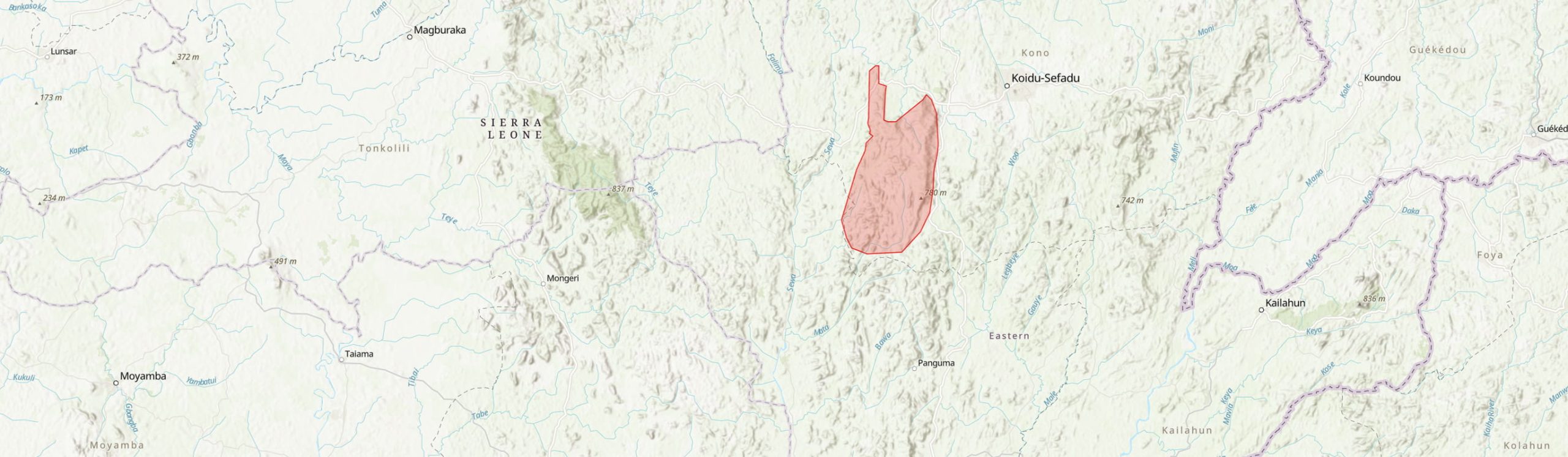
Country: Sierra Leone
Administrative region: Eastern (Province)
Central co-ordinates: 8.07000 N, 11 W
Area: 352.8km²
Qualifying IPA Criteria
A(i)Site contains one or more globally threatened species
IPA assessment rationale
The Nimini Hills North IPA hosts two globally threatened species and is recognized as the best site nationally for Cola boxiana EN, therefore meeting criterion A(i). Approximately 50% of intact forest within this IPA remains intact, suggesting there maybe additional threatened species yet to be recorded in this area. Extensive research is necessary to confirm species presence. A well-structured management plan could potentially trigger criterion C(iii) for this IPA, which is currently accounts for 5% of moist evergreen forest in the country. However, the IPA is under immense threats of mining and logging activities.
Site description
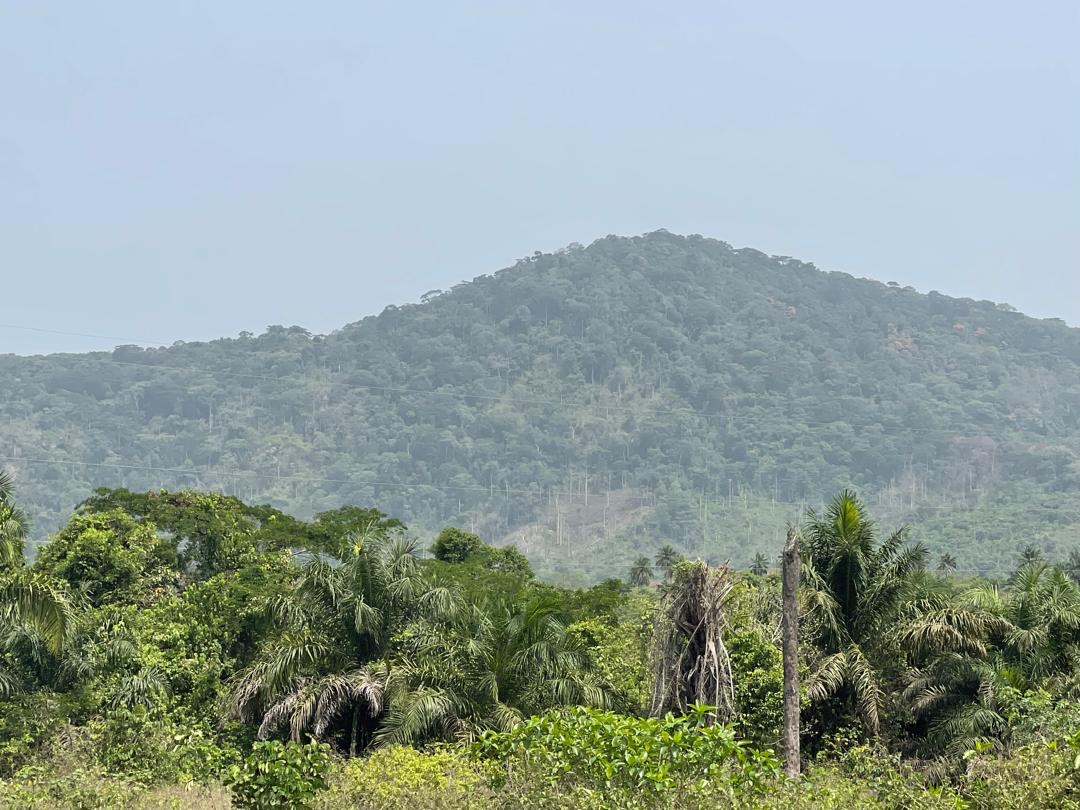
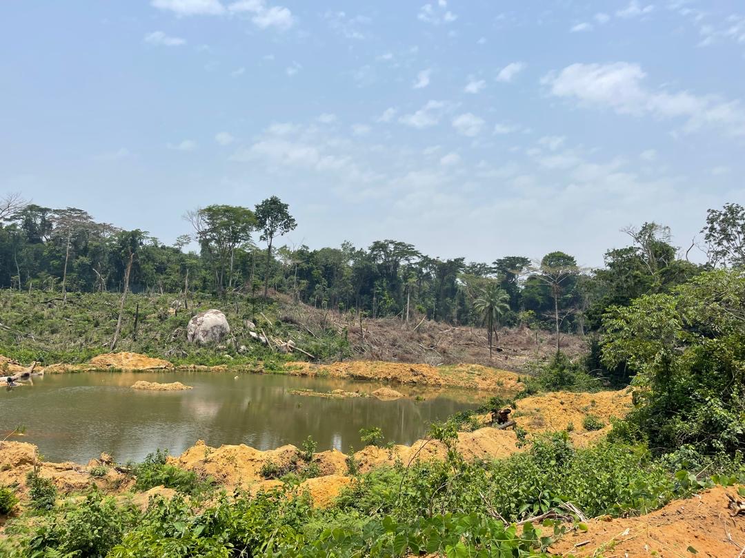
The Nimini Hills Important Plant Area encompasses the Nimini Hills forest reserve, which is approximately 129 km², along with surrounding areas located in the southwest of Kono District. The Nimini Hills North forest shares boundaries with three chiefdoms: Nimiyama, Nimikoro, and Gorama. The nearest city, Koidu, is located about 40 kilometers away. The site is situated on distant mountains that are characterized by gaps and rolling hills, and it contains some good stands of undisturbed forests, totalling around 12,000 ha, However, mining and logging activities have significantly affected the portion of land shared with Nimikoro Chiefdom, resulting in existence of several substantial forest fragments within the IPA.
Botanical significance
The Nimini North IPA is biologically significant, it help protect an intact forest significant within the upper Guinean biodiversity hotspot and it contains two globally threatened plant species Cola boxiana EN and Combretum fulvum. The near threatened is also commonly found within this IPA Trichoscypha longifolia. Large tree species may include Parkia bicolor, Uapacca guniensis, Cola chlamydantha, Pyncnanthus angolensis, Canarium schweinfurthii Albizia zygia, Xylopia aethiopica, Piptadeniastrum africanum, Terminalia ivoriensis, Terminalia superba, Terminalia superba, and Chlorophora regia with a diverse understory of small trees, shrubs, and herbs. The higher slopes support forest with smaller-stature trees, and abundant epiphytes (Vines).
Habitat and geology
The vegetation of Nimini Hills North is characterised by moist evergreen and semi-deciduous forests on hill slopes with disturbances largely occurring mostly in the southeast of the reserve and beyond (Terry, 2012). Intact moist evergreen and semi-deciduous forests constitute about 45 % of the area, while the remaining vegetation includes vine forest formations (24.3), likely influenced by soil type or slope, as well as disturbed vegetation such as farm bush and secondary forest mostly located outside the reserve (Terry, 2012).
The IPA is situated in a wet microclimate, where the rolling hills act as topographic impediment against wet-season inclement weather systems from the Atlantic, resulting in an average annual rainfall of 2,659 mm. The site's elevation ranges between 232 to 750 m above sea level, with the topography varying from flat bottomlands to steep hillsides, and rounded ridge-tops (Terry, 2012). Geologically, the site is part of an Archean greenstone belt, measuring 2 to 8 km wide, lying within the West African Craton of the African Shield. It is surrounded by granitoid rocks to the east and west, interbanded with sedimentary formations,
including banded ironstones. The topsoil is deep and well drained with some laterite present, underlain by metamorphic rocks (Lebbie et al., 2023).
Conservation issues
The main threats within this IPA includes extensive mining of gold and diamonds, despite Nimini Hill North being designated as a forest reserve in 1921. In 2008, the Trans-Atlantic Logging Mompany conducted a forest inventory (results unpublished) in Nimini Hills North Extension 1, which led to a temporary logging ban and shut down of commercial logging in the district in 2009 (Terry, 2012). Currently, a mining company, Wongor Mining Company, has been allocated 2/3 of the land for gold mining, while another company, Treesdales Company, has been granted logging rights within sections of the forest reserve. The mining company occupies approximately 15% of the available land in the region; however, the boundary is unclear to community members as they currently have a 25-years lease agreement with the government (Terry, 2012; Lebbie et al., 2023). Additionally, small-scale logging using power saws is rampant, with only a few saw owners obtaining timber licenses. The Nimini Hills Forest Reserve is already a significantly depleted and threatened forest, showing very few signs of wildlife and human footprints evident throughout the reserve, except in the far south. To preserve much of its forest cover in the future, a comprehensive inventory of all plant species, threats, and their status is required, alongside stringent management of the forest resources to maintain this vital resource. Control of small-scale logging with power saws are essential to prevent further depletion of standing timber in the reserve.
The road network to the site is in dilapidated and challenging condition.
Ecosystem services
The area provides raw materials and food for local communities. Portions of the land are cleared for farm bush and slash-and-burn agriculture, primarily for cacao and other vegetables, which supports the livelihood of local residents (Lebbie et al., 2023; Terry, 2012). In addition, the area is home to a several animal species such as Maxwell's duiker, black duiker, bushbuck, red river hog, bay duiker, yellow-backed duiker, porcupine, civet, and Colobus monkey. These species are under immense threat of poaching activities throughout the region (Terry, 2012).
Site assessor(s)
Assessed by:
Fanny Massally, Royal Botanic Gardens, Kew
Date of first assessment: 10th Apr 2026
Reviewed by:Aiah Lebbie, The University of Sierra Leone
IPA criterion A species
| Species | Qualifying sub-criterion | ≥ 1% of global population | ≥ 5% of national population | 1 of 5 best sites nationally | Entire global population | Socio-economically important | Abundance at site |
|---|---|---|---|---|---|---|---|
| Homalium smythei Hutch. & Dalziel | A(i) |  |
|
|
|
|
Occasional |
| Cola boxiana | A(i) | |
|
 |
|
|
Scarce |
Homalium smythei Hutch. & Dalziel
Qualifying sub-criterion:
A(i)
≥ 1% of global population:
≥ 5% of national population:
1 of 5 best sites nationally:
Entire global population:
Socio-economically important:
Abundance at site:
Occasional
Cola boxiana
Qualifying sub-criterion:
A(i)
≥ 1% of global population:
≥ 5% of national population:
1 of 5 best sites nationally:
Entire global population:
Socio-economically important:
Abundance at site:
Scarce
IPA criterion C qualifying habitats
| Habitat | Qualifying sub-criterion | ≥ 5% of national resource | ≥ 10% of national resource | 1 of 5 best sites nationally | Areal coverage at site |
|---|---|---|---|---|---|
| Low-altitude evergreen forest and gallery forest | C(i) | |
|
|
Low-altitude evergreen forest and gallery forest
Qualifying sub-criterion:
C(i)
≥ 5% of national resource:
≥ 10% of national resource:
Areal coverage at site:
General site habitats
| General site habitat | Percent coverage | Importance |
|---|---|---|
| Forest - Subtropical/Tropical Moist Lowland Forest | 50 | Major |
| Forest - Subtropical/Tropical Swamp Forest | 15 | Minor |
| Artificial - Terrestrial - Arable Land | 35 | Unknown |
Forest - Subtropical/Tropical Moist Lowland Forest
Percent coverage:
50
Importance:
Major
Forest - Subtropical/Tropical Swamp Forest
Percent coverage:
15
Importance:
Minor
Artificial - Terrestrial - Arable Land
Percent coverage:
35
Importance:
Unknown
Land use types
| Land use type | Percent coverage | Importance |
|---|---|---|
| Agriculture (arable) | |
|
| Nature conservation | |
|
| Extractive industry | |
Agriculture (arable)
Percent coverage:
Importance:
Nature conservation
Percent coverage:
Importance:
Extractive industry
Percent coverage:
Importance:
Threats
| Threat | Severity | Timing |
|---|---|---|
| Agriculture & aquaculture - Annual & perennial non-timber crops | Medium | Ongoing - increasing |
| Energy production & mining - Mining & quarrying | High | Ongoing - increasing |
| Pollution - Domestic & urban waste water | Medium | Ongoing - increasing |
| Biological resource use - Hunting & collecting terrestrial animals - Unintentional effects (species being assessed is not the target) | High | Ongoing - increasing |
Agriculture & aquaculture - Annual & perennial non-timber crops
Severity:
Medium
Timing:
Ongoing - increasing
Energy production & mining - Mining & quarrying
Severity:
High
Timing:
Ongoing - increasing
Pollution - Domestic & urban waste water
Severity:
Medium
Timing:
Ongoing - increasing
Biological resource use - Hunting & collecting terrestrial animals - Unintentional effects (species being assessed is not the target)
Severity:
High
Timing:
Ongoing - increasing
Protected areas
| Protected area name | Protected area type | Relationship with IPA | Areal overlap |
|---|---|---|---|
| Nimini North Forest reserve | National Reserve | IPA encompasses protected/conservation area | 129 |
Nimini North Forest reserve
Protected area type:
National Reserve
Relationship with IPA:
IPA encompasses protected/conservation area
Areal overlap:
129
Bibliography
NI 43-101 Technical Report on the Resource Update Nimini Gold Project, Kono Region, Sierra Leone
Field Report on Assessment of Forest Reserves for Potential Restoration by Rainforest Builders in Sierra Leone
unpublished
Sierra Leone National Chimpanzee Census.


Recommended citation
Fanny Massally (2026) Tropical Important Plant Areas Explorer: Nimini Hill North (Sierra Leone). https://tipas.kew.org/site/nimini-hills-north/ (Accessed on 25/08/2026)