
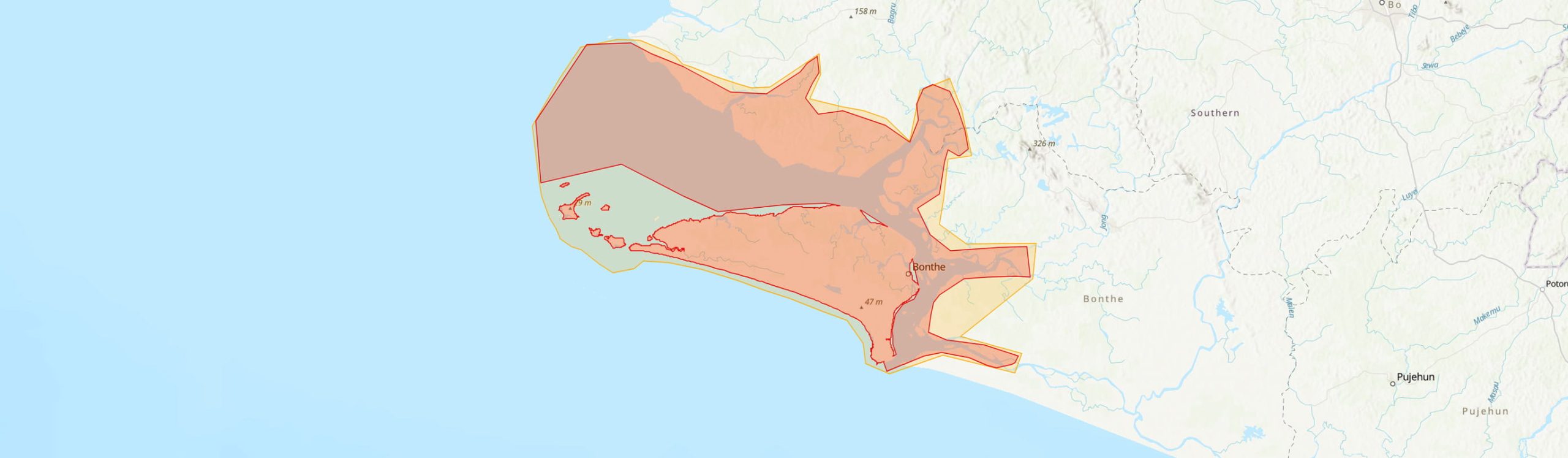
Country: Sierra Leone
Administrative region: Southern (Province)
Central co-ordinates: 7.50000 N, 12.7 W
Area: 3073.3km²
Qualifying IPA Criteria
A(i)Site contains one or more globally threatened species, A(iv)Site contains one or more range restricted endemic species that are potentially threatened, C(i)Site contains globally threatened or restricted habitat or vegetation types
IPA assessment rationale
The Sherbro Island and archipelagos IPA qualify under Criterion A(i) as they hold nationally significant populations of a species that triggers A(i) Eugenia liberiana, as well as another range restricted plant that would likely be threatened triggering A(iv). Its also triggers criterion C(i) due to presence of the threatened seagrass meadow habitat found in turtle island of this IPA.
Site description
The Sherbro Island and Archipelagos Important Plant Area (IPA) is located in Bonthe District, Southern Province, Sierra Leone, along the southwestern coast. The IPA encompasses Sherbro Island, the Turtle Islands archipelago, and the Sherbro River Estuaries (SRE), forming a mixture of coastal estuarine habitats with high ecological significance.
Sherbro Island is the largest landmass within the IPA and spans approx. 620 km². It is about 51 km long and 24 km wide and is bordered by an extensive network of estuaries to the north and east, with the Atlantic Ocean forming its southern and western boundaries. The Turtle Islands lie offshore to the west, surrounding the main island with other archipelagos, such as the York Island throughout the SRE. The Sherbro River Estuary is one of the four marine protected areas in Sierra Leone and is approximately 283.54 km².
Botanical significance
The Sherbro Island and archipelagos IPA is home to a unique assemblage of plant species adapted to its coastal, estuarine, sandy, and saline environments. Although botanical collections were made during the colonial period by Garrett and Deighton, and there are few recent botanical survey, a comprehensive botanical surveys is required to document plant diversity across the IPA, especially on Sherbro Island. The IPA is the type locality for Macropodiella garrettii (Podostemaceae; Garrett s.n., 1893). However, the precise waterfall habitat required by Podostemaceae has not yet been traced within this IPA and must be targeted. Eulophia distans which is endemic to Sierra Leone has also been recorded in this IPA.
The IPA also holds nationally significant populations of the rare coastal species Eugenia liberiana (EN), which is known in Sierra Leone from only a single confirmed collection within this IPA. Additionally, the Critically Endangered Eriostema arenicola (CR), recorded from the Turtle Islands, is confirmed within the IPA and may possibly occur on Sherbro Island as well. Vulnerable tree species Copalifera salikounda (VU) and Haplomorsia monophylla (VU) have been recorded at the site; however, these species do not meet thresholds to qualify as IPA priority species.
Due to the island's 'Coastal Park Savanna' habitat (Cole 1968), additional rare or threatened species are likely to occur, including Fegimanra acuminatissima (VU) and potentially species new to science (Jongkind & Breteler, 2020). Economic tree species recorded within this IPA include but are not limited to, Neocarya macrophylla, Dodonaea viscosa, Terminalia albida, Diospyros elliotii, Philoxerus vermicularis, Ipomoea stolonifera, Ipomoea pes-caprae, and Triumfetta tomentosa (Zebedee & Sainge, 2021).
Habitat and geology
The IPA supports diverse habitats such as coastal, estuarine, and terrestrial habitats. The Sherbro Island forms part of the Guinean mangrove ecoregion with the most pristine mangrove swamps in West Africa (Anthony, 2004; Olson et al., 2001) and is characterized by coastal thicket, mangroves, freshwater swamps, 'coastal park savanna,' and forest.
Mangrove vegetation dominates the coastal and estuarine areas, with species such as Avicennia nitida (Black Mangrove) on mudflats inundated by medium to high tides. Along better-drained estuarine banks, Rhizophora racemosa commonly occurs in association with Avicennia (Johnson & Johnson, 2012). The dominant mangrove species are R. racemosa, R. mangle and A. germinans. Laguncularia racemosa and R. harrisonnii (Anthony, 2004). Other widespread mangrove species like Conocarpus erectus is sometimes found where tidal flooding is limited to the highest spring tides (Anthony, 2004), and forests surrounding coastal lagoons may contain characteristic woody species like Cassipourea barteri, Chrysobalanus icaco subsp. icaco, Dalbergia ecastaphyllum and Phoenix reclinata (Jongkind & Breteler, 2020). In places, this transitional zone consists of poorly drained freshwater grasslands of Eleocharis dulcis, sometimes mixed with Eichornia natans and Nymphoides indica. The island includes approx. 315 km2 of 'Coastal Park Savanna' habitat on old beach sand (Cole, 1968) and retains patches of primary forest vegetation along its northern edge (Protected Planet, 2024).
The IPA receives an annual rainfall of up to 4,000 mm, and a rainy season from March to September (Zebedee & Sainge, 2021). The temperature is 24 degrees in August, 28 degrees in March and can go up to 40 degrees due to heat waves (Trzaska et al., 2017). Geologically, Sherbro Island and the archipelagos are flat areas that extends into a continental shelf with a gentle gradient, primarily consisting of alluvial and marine sediments (Anthony, 2004). These sediments form sandy soils in the island's interior and silty mudflats along its coastline.
The region rests on the Bullom Group of soils, deposited during the Tertiary to Quaternary Holocene period, comprising poorly consolidated marine and estuarine sediments characterized by compacted, cohesive silts and clay (Egbenda et al., 2015; Zebedee & Sainge, 2021).
Conservation issues
Sherbro Island, as part of the IPA, is under concession for a proposed large-scale urban development project called Sherbro Island City in 2025, and this development could significantly impact local habitats and plant life with poor management.The National Protected Area Authority does not manage the Sherbro Island. However, the SRE is administratively governed by the Bonthe Municipal Council and Bonthe and Moyamba District Councils.
The Coastal Park Savanna habitat within the IPA, characterized by sandy substrates is unsuitable for agriculture, and currently experiences relatively limited human disturbance.
Rice cultivation does not affect this IPA as in other parts of West Africa, where large areas of mangroves have been deforested (Anthony, 2004). However, they still experience substantial pressures from extraction of fuel wood, land degradation, coastal erosion, and intensive fishing practices (Johnson & Johnson, 2012). Additionally, this IPA is vulnerable to loss of coastal plain areas due to flooding and erosion associated with climatic change and sea-level rise (Anthony, 2004).
Ecosystem services
Sherbro Island is a culturally significant site for the Sherbro people, who rely on the island’s natural resources for their livelihoods such as oyster harvesting and other traditional practices. Small fishing and farming communities, with Bonthe Town being the largest settlement make up the island's population. Despite its limited facilities, Sherbro Island holds potential as a tourist destination.
The IPA contains suitable habitat for seagrass meadows, one of the endemic vegetation types in Sierra Leone. Only one seagrass type, Halodule wrightii, has been recorded in three areas in the Turtle Island (Bumpetok, Sei and Mania Island) of the Sherbro River Estuary (Ndure, 2023). Sherbro Island is a breeding ground for turtles and fishes due to its large mangrove swamp area (Johnson & Johnson, 2012).
Site assessor(s)
Assessed by:
Gabriella Hoban, Royal Botanic Gardens, Kew
Fanny Massally, Royal Botanic Gardens, Kew
Date of first assessment: 1st Apr 2025
Reviewed by:Xander van der Burgt, The Royal Botanic Gardens Kew
Martin Cheek, The Royal Botanic Gardens Kew
IPA criterion A species
| Species | Qualifying sub-criterion | ≥ 1% of global population | ≥ 5% of national population | 1 of 5 best sites nationally | Entire global population | Socio-economically important | Abundance at site |
|---|---|---|---|---|---|---|---|
| Eugenia liberiana Amshoff | A(i) |  |
|
|
 |
|
Unknown |
| Macropodiella garrettii (C. H. Wright) C.Cusset | A(iv) | |
|
|
|
|
Unknown |
| Eriosema arenicola (Verdc.) Maesen & Wieringa | A(i) | |
|
|
|
|
Unknown |
Eugenia liberiana Amshoff
Qualifying sub-criterion:
A(i)
≥ 1% of global population:
≥ 5% of national population:
1 of 5 best sites nationally:
Entire global population:
Socio-economically important:
Abundance at site:
Unknown
Macropodiella garrettii (C. H. Wright) C.Cusset
Qualifying sub-criterion:
A(iv)
≥ 1% of global population:
≥ 5% of national population:
1 of 5 best sites nationally:
Entire global population:
Socio-economically important:
Abundance at site:
Unknown
Eriosema arenicola (Verdc.) Maesen & Wieringa
Qualifying sub-criterion:
A(i)
≥ 1% of global population:
≥ 5% of national population:
1 of 5 best sites nationally:
Entire global population:
Socio-economically important:
Abundance at site:
Unknown
IPA criterion C qualifying habitats
| Habitat | Qualifying sub-criterion | ≥ 5% of national resource | ≥ 10% of national resource | 1 of 5 best sites nationally | Areal coverage at site |
|---|---|---|---|---|---|
| Seagrass Meadows | C(i) | |
|
|
Seagrass Meadows
Qualifying sub-criterion:
C(i)
≥ 5% of national resource:
≥ 10% of national resource:
Areal coverage at site:
General site habitats
| General site habitat | Percent coverage | Importance |
|---|---|---|
| Forest - Subtropical/Tropical Mangrove Forest Vegetation Above High Tide Level | |
|
| Forest - Subtropical/Tropical Swamp Forest | |
|
| Savanna - Moist Savanna | |
|
| Shrubland - Subtropical/Tropical Moist Shrubland | |
|
| Wetlands (inland) - Permanent Rivers, Streams, Creeks [includes waterfalls] | |
|
| Marine Neritic (Submergent Nearshore Continental Shelf or Oceanic Island) - Subtidal Sandy-Mud | |
|
| Marine Neritic (Submergent Nearshore Continental Shelf or Oceanic Island) - Estuaries | |
|
| Marine Coastal/Supratidal - Coastal Sand Dunes | |
|
| Marine Coastal/Supratidal - Coastal Brackish/Saline Lagoons/Marine Lakes | |
Forest - Subtropical/Tropical Mangrove Forest Vegetation Above High Tide Level
Percent coverage:
Importance:
Forest - Subtropical/Tropical Swamp Forest
Percent coverage:
Importance:
Savanna - Moist Savanna
Percent coverage:
Importance:
Shrubland - Subtropical/Tropical Moist Shrubland
Percent coverage:
Importance:
Wetlands (inland) - Permanent Rivers, Streams, Creeks [includes waterfalls]
Percent coverage:
Importance:
Marine Neritic (Submergent Nearshore Continental Shelf or Oceanic Island) - Subtidal Sandy-Mud
Percent coverage:
Importance:
Marine Neritic (Submergent Nearshore Continental Shelf or Oceanic Island) - Estuaries
Percent coverage:
Importance:
Marine Coastal/Supratidal - Coastal Sand Dunes
Percent coverage:
Importance:
Marine Coastal/Supratidal - Coastal Brackish/Saline Lagoons/Marine Lakes
Percent coverage:
Importance:
Land use types
| Land use type | Percent coverage | Importance |
|---|---|---|
| Nature conservation | |
|
| Agriculture (arable) | |
|
| Agriculture (aquatic) | |
|
| Tourism / Recreation | |
|
| Industrial development | |
Nature conservation
Percent coverage:
Importance:
Agriculture (arable)
Percent coverage:
Importance:
Agriculture (aquatic)
Percent coverage:
Importance:
Tourism / Recreation
Percent coverage:
Importance:
Industrial development
Percent coverage:
Importance:
Protected areas
| Protected area name | Protected area type | Relationship with IPA | Areal overlap |
|---|---|---|---|
| Bonthe Mangrove Swamp | National Nature Reserve | IPA encompasses protected/conservation area | |
Bonthe Mangrove Swamp
Protected area type:
National Nature Reserve
Relationship with IPA:
IPA encompasses protected/conservation area
Areal overlap:
Management type
| Management type | Description | Year started | Year finished |
|---|---|---|---|
| No management plan in place | Sherbro Island | |
|
| Protected Area management plan in place | Sherbro Island Eustuary | |
|
No management plan in place
Sherbro Island
Year started:
Year finished:
Protected Area management plan in place
Sherbro Island Eustuary
Year started:
Year finished:
Bibliography
Terrestrial ecoregions of the world: a new map of life on earth
Bioscience, Vol 51, page(s) 3-938
The Vegetation of Sierra Leone
The mangrove and coastal environment of Sierra Leone
The Marine Fisheries Environment of Sierra Leone: Belated Proceedings of a National Seminar held in Freetown, 25-29 November 1991 (pub. Fisheries Centre Research Reports 20)
Sediment dynamics and morphological stability of estuarine mangrove swamps in Sherbro Bay, West Africa
Marine Geology, Vol 208, page(s) 207-244
Sierra Leone and the Interior, to the Upper Waters of the Niger
Royal Geographical Society, Vol 14
Englerodendron libassum (Leguminosae-Detarioideae-Amherstieae), a new Critically Endangered tree species from coastal Liberia
Plant Ecology and Evolution, Vol 153, page(s) 487-491
The Turtle Bank, Sherbro bay, west Africa: estuarine-modified inner shelf shoal?
Marine Sandwave and River Dune Dynamics
A PRELIMINARY ASSESSMENT OF ECOSYSTEM SERVICES IN THE SHERBRO RIVER ESTUARY, SOUTHERN SIERRA LEONE
A physico-chemical analysis of soil and selected fruitsin one rehabilitated mined out site in the Sierra Rutile environs for the presence of heavy metals: Lead,Copper, Zinc, Chromium and Arsenic.
Climate change vulnerability assessment in mangrove regions of Sierra Leone: Long version. Report published under the USAID West Africa Biodiversity and and Climate Change (WA BiCC) project.
Palisades, NY: Center for international Earth Science information Network, Columbia University Available online
An assessment of Seagrass Meadows and ecosystem Services in Turtle Islands, Sierra Leone


Recommended citation
Gabriella Hoban, Fanny Massally (2026) Tropical Important Plant Areas Explorer: Sherbro Island and archipelagos (Sierra Leone). https://tipas.kew.org/site/sherbro-island/ (Accessed on 25/08/2026)