
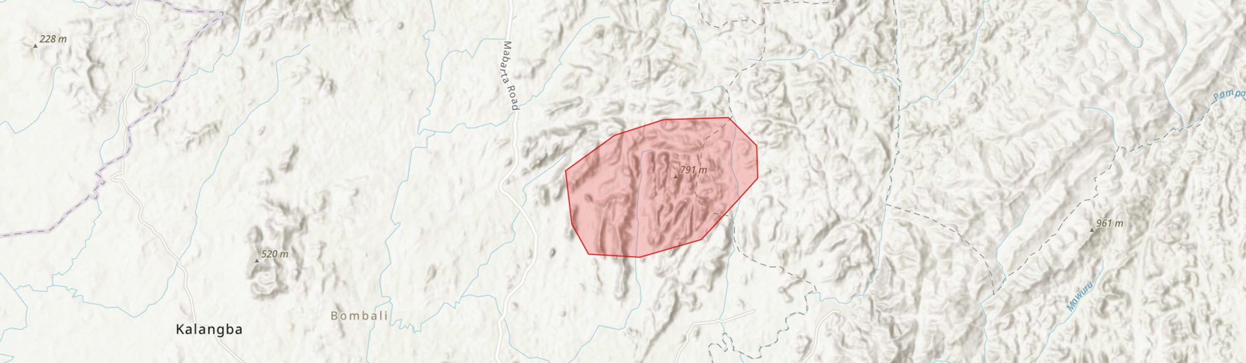
Country: Sierra Leone
Administrative region: Northern (Province)
Central co-ordinates: 9.13000 N, 11.84 W
Area: 104.3km²
Qualifying IPA Criteria
A(i)Site contains one or more globally threatened species
IPA assessment rationale
The Gbenabe Hills qualify as an IPA based on the presence of fourteen globally threatened plant species that trigger criteria A(i).
Site description
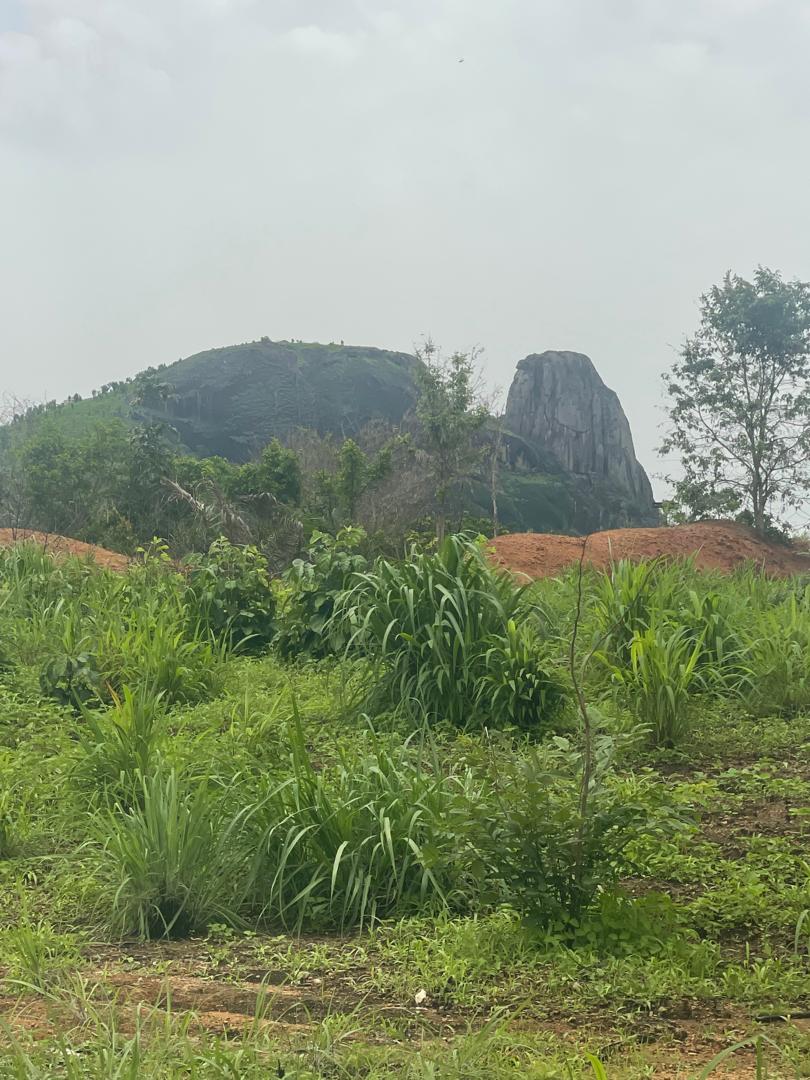
The Gbenabe Hills IPA is located in the Northern Province of Sierra Leone, spanning the Bombali and Koinadugu Districts, approximately 34 km north-east of the town of Makeni. The area is defined by rugged hills and deeply incised valleys that form part of Sierra Leone’s Eastern Highlands. The hills rise to elevations of approximately 770 metres above sea level and support a mosaic of habitats, including inselbergs, lowland forest and savanna.
Local place names in this area can be inconsistent across mapping platforms. For example, Google products have misallocated village names in the region, leading to some confusion. Additionally, the name “Gbenabe Hills” is not used consistently by local communities and is variably recorded in the literature as "Gbengbe" or "Gbenge."
Botanical significance
The Gbenabe Hills IPA supports significant populations of at least twelve globally threatened plant taxa, including two national endemics: Inversodicraea mortonii (VU, in draft) and Bryaspis humularioides subsp. falcistipulata (CR, in draft). The latter is only known from this IPA, though its taxonomic validity is disputed (X. van der Burgt, pers. comms., 2025).
The botanical significance of the area is long-recognised. It was first surveyed in the colonial era by Granville and Thomas, and later by J.K. Morton in 1965. These collectors referred to the site as the “Gbenge Hills” and cited Bumban School as a notable collecting locality. During the 2025 TIPAs field visit, surveys focused on the northern section of the hills and the vicinity of Bumban School. However, further research is needed to document the site's full botanical diversity, particularly during the wet season, when seasonal inselberg vegetation is detectable.
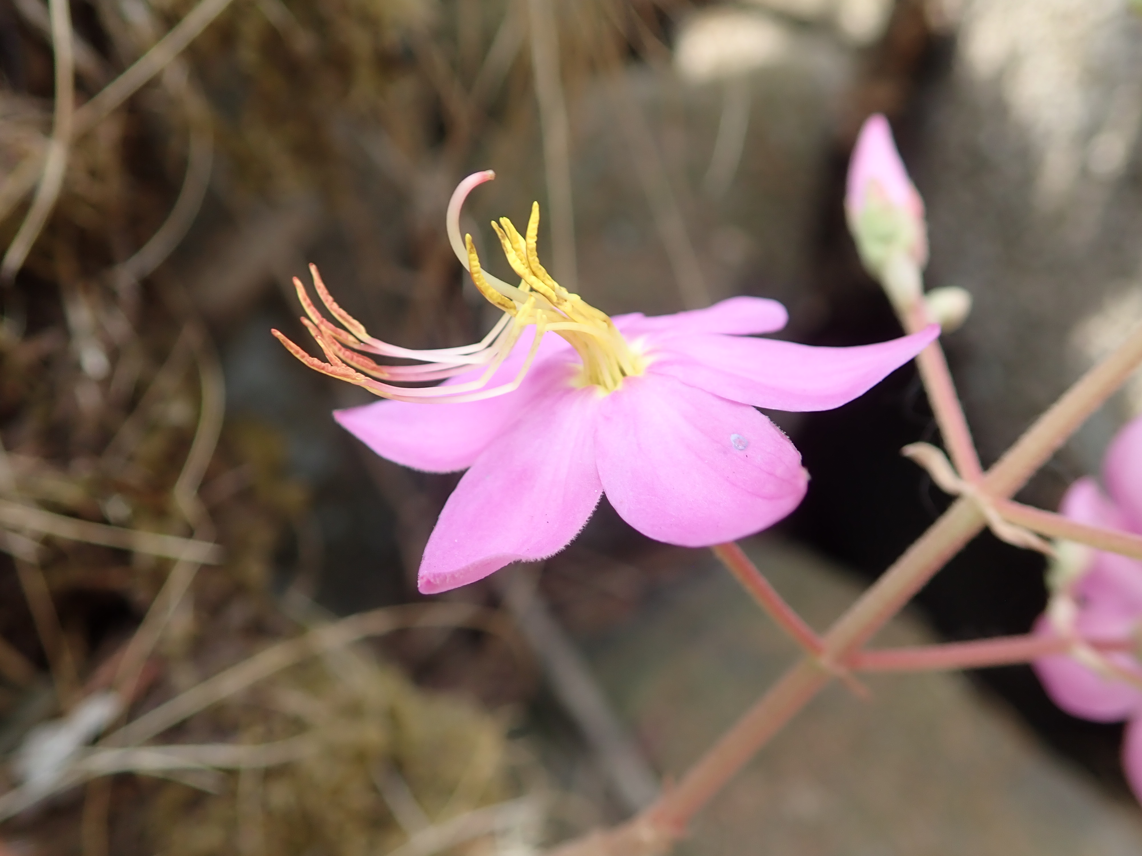
From current knowledge, this IPA is one of only two globally known locations for Inversodicraea mortonii, which has not been recorded since the type collection in 1965 (Morton #SL2899). Bryaspis humularioides subsp. falcistipulata is likewise known only from this IPA and has not been recollected since the same expedition (Morton #SL2886). Additionally, this is the only known location in Sierra Leone for the Endangered tuberous herb Bourdaria fecilis (syn. Cincinnobotrys felicis, Melastomataceae), last collected in 1932 (Granville #435). Although the species was not observed during recent fieldwork in the vicinity of the original collecting locality and adjacent suitable habitats—namely sheltered rocky areas with continuous moisture—surveys were limited and took place during the dry season. It is likely the species persists and would be more detectable during its June–September flowering period, when its distinctive bright pink flowers emerge.
The northern forests of the IPA contain stands of the Near Endemic and Vulnerable tree Brachystegia leonensis (Detarioideae) and Placodiscus oblongifolius (VU). Gallery forest along rocky streams, characterized by large granite boulders, hosts additional rare species such as Cryptosepalum tetraphyllum (VU) and Neolemonniera clitandrifolia (VU).
Inselberg microhabitats within the site support several threatened species, including the shrub Paleodissotis leonensis (formerly Dissotis leonensis), the Endangered herb Raphionacme caerulea, the Endangered grass Schizachyrium djalonicum, and the Vulnerable carnivorous herb Utricularia macrocheilos. Given the size and heterogeneity of habitats at the site, it is highly likely that additional species of conservation concern remain to be documented at the site.
Habitat and geology
The characteristic rugged terrain of the Gbenabe Hills is underlain by outcropping Precambrian metamorphic rocks, predominantly schist and granite. These ancient formations have resulted in nutrient-poor soils (SoilGrids, 2025). To the south of the site, the Rokel River Series underlies the lowland area. This geological unit consists of sedimentary rocks such as sandstone and siltstone (van Vuure & Miedema, 1973).
The dominant habitats in the Gbenabe Hills include granite inselbergs, associated with shield and dome landform features. These higher-elevation formations contain a range of microhabitats (Porembski et al., 1994), including Afrotrilepis mats, seasonally flooded grasslands and some isolated patches of woody vegetation. At lower elevations, inselberg habitats transition into lowland forest, gallery forest along drainage lines or savanna. The IPA lies within the ecotone between savanna and closed-canopy forest (Cole, 1968), resulting in a dynamic forest–savanna mosaic. Closed-canopy forest at the base of the hills is discontinuous and largely secondary in nature. Gallery forest is present in several areas, particularly along rocky streambeds, and supports plant species of high conservation importance. A patch of high-quality forest is found in the southern part of the IPA remains to be botanically explored (Google Earth Imagery, 2025). Low-altitude lateritic pan grasslands are also likely to occur within the IPA, though field verification is required to confirm their extent and composition.
Conservation issues
The Gbenabe Hills face a range of conservation challenges. The IPA is sparsely populated but surrounded by numerous villages, and currently receives no formal protection. It is not yet recognised on national conservation planning maps or designated as a protected area.
One of the most pressing threats is the potential for small-scale and artisanal mining, particularly for diamonds and gold. Although the area is not currently covered by any active mining licences (GoSL, 2024), the geological formations of the hills, including the granite inselbergs, may be targeted in future. Past mining activities in nearby areas have already caused habitat degradation and water pollution, and expansion into the Gbenabe Hills would present a significant risk to intact vegetation and endemic species.
Logging and agricultural encroachment are already impacting the IPA, particularly in the more accessible lowland areas. These activities are fragmenting and reducing forest cover. Uncontrolled bushfires—often set intentionally to clear land for agriculture—pose another major threat. These fires are widespread and frequent, and are damaging to habitats at the site. Species such as Paleodissotis leonensis are especially vulnerable to fire and may be at risk of local extinction if fires increase in frequency or intensity.
Initial conversations with local communities during field visits revealed a willingness to engage with conservation efforts. However, there is a clear need for further dialogue, participatory planning, and community-based awareness-raising initiatives to foster long-term stewardship and reduce human pressures on the site.
Ecosystem services
Ecosystem services are sparsely documented at the site. The Gbenabe Hills provide vital ecosystem services that support both biodiversity and local livelihoods. Vegetation cover on the hills helps prevent soil erosion on steep slopes, protecting downstream areas from sedimentation and maintaining landscape stability. In addition to ecological functions, the Gbenabe Hills have cultural and spiritual significance for nearby communities. Local people rely on the area’s natural resources for traditional practices, medicinal use, and subsistence livelihoods, highlighting the importance of community engagement in any future conservation planning.
Site assessor(s)
Assessed by:
Gabriella Hoban, Royal Botanic Gardens, Kew
Fanny Massally, Royal Botanic Gardens, Kew
Date of first assessment: 25th Apr 2025
Reviewed by:Martin Cheek, The Royal Botanic Gardens Kew
Xander van der Burgt, The Royal Botanic Gardens Kew
IPA criterion A species
| Species | Qualifying sub-criterion | ≥ 1% of global population | ≥ 5% of national population | 1 of 5 best sites nationally | Entire global population | Socio-economically important | Abundance at site |
|---|---|---|---|---|---|---|---|
| Bryaspis humularioides subsp. falcistipulata Gledhill | A(i) |  |
|
|
|
 |
Unknown |
| Inversodicraea mortonii (C.Cusset) Cheek | A(i) | |
|
|
|
|
Unknown |
| Raphionacme caerulea E.A.Bruce | A(i) | |
|
|
|
|
Unknown |
| Bourdaria felicis A.Chev. | A(i) | |
|
|
|
|
Unknown |
| Brachystegia leonensis Hutch. & Burtt Davy | A(i) | |
|
|
|
|
Occasional |
| Cryptosepalum tetraphyllum (Hook.f.) Benth. | A(i) | |
|
|
|
|
Occasional |
| Monocymbium lanceolatum C.E.Hubb. | A(i) | |
|
|
|
|
Unknown |
| Neolemonniera clitandrifolia A.Chev. | A(i) | |
|
|
|
|
Scarce |
| Paleodissotis leonensis (Hutch. & Dalziel) Ver.-Lib. & Burgt | A(i) | |
|
|
|
|
Scarce |
| Raphionacme caerulea E.A.Bruce | A(i) | |
|
|
|
|
Unknown |
| Utricularia macrocheilos (P.Taylor) P.Taylor | A(i) | |
|
|
|
|
Unknown |
| Schizachyrium djalonicum Jacq.-Fél. | A(i) | |
|
|
|
|
Unknown |
| Anadelphia trichaeta (Reznik) Clayton | A(i) | |
|
|
|
|
|
| Cincinnobotrys felicis (A.Chev.) Jacq.-Fél. | A(i) | |
|
|
|
|
Bryaspis humularioides subsp. falcistipulata Gledhill
Qualifying sub-criterion:
A(i)
≥ 1% of global population:
≥ 5% of national population:
1 of 5 best sites nationally:
Entire global population:
Socio-economically important:
Abundance at site:
Unknown
Inversodicraea mortonii (C.Cusset) Cheek
Qualifying sub-criterion:
A(i)
≥ 1% of global population:
≥ 5% of national population:
1 of 5 best sites nationally:
Entire global population:
Socio-economically important:
Abundance at site:
Unknown
Raphionacme caerulea E.A.Bruce
Qualifying sub-criterion:
A(i)
≥ 1% of global population:
≥ 5% of national population:
1 of 5 best sites nationally:
Entire global population:
Socio-economically important:
Abundance at site:
Unknown
Bourdaria felicis A.Chev.
Qualifying sub-criterion:
A(i)
≥ 1% of global population:
≥ 5% of national population:
1 of 5 best sites nationally:
Entire global population:
Socio-economically important:
Abundance at site:
Unknown
Brachystegia leonensis Hutch. & Burtt Davy
Qualifying sub-criterion:
A(i)
≥ 1% of global population:
≥ 5% of national population:
1 of 5 best sites nationally:
Entire global population:
Socio-economically important:
Abundance at site:
Occasional
Cryptosepalum tetraphyllum (Hook.f.) Benth.
Qualifying sub-criterion:
A(i)
≥ 1% of global population:
≥ 5% of national population:
1 of 5 best sites nationally:
Entire global population:
Socio-economically important:
Abundance at site:
Occasional
Monocymbium lanceolatum C.E.Hubb.
Qualifying sub-criterion:
A(i)
≥ 1% of global population:
≥ 5% of national population:
1 of 5 best sites nationally:
Entire global population:
Socio-economically important:
Abundance at site:
Unknown
Neolemonniera clitandrifolia A.Chev.
Qualifying sub-criterion:
A(i)
≥ 1% of global population:
≥ 5% of national population:
1 of 5 best sites nationally:
Entire global population:
Socio-economically important:
Abundance at site:
Scarce
Paleodissotis leonensis (Hutch. & Dalziel) Ver.-Lib. & Burgt
Qualifying sub-criterion:
A(i)
≥ 1% of global population:
≥ 5% of national population:
1 of 5 best sites nationally:
Entire global population:
Socio-economically important:
Abundance at site:
Scarce
Raphionacme caerulea E.A.Bruce
Qualifying sub-criterion:
A(i)
≥ 1% of global population:
≥ 5% of national population:
1 of 5 best sites nationally:
Entire global population:
Socio-economically important:
Abundance at site:
Unknown
Utricularia macrocheilos (P.Taylor) P.Taylor
Qualifying sub-criterion:
A(i)
≥ 1% of global population:
≥ 5% of national population:
1 of 5 best sites nationally:
Entire global population:
Socio-economically important:
Abundance at site:
Unknown
Schizachyrium djalonicum Jacq.-Fél.
Qualifying sub-criterion:
A(i)
≥ 1% of global population:
≥ 5% of national population:
1 of 5 best sites nationally:
Entire global population:
Socio-economically important:
Abundance at site:
Unknown
Anadelphia trichaeta (Reznik) Clayton
Qualifying sub-criterion:
A(i)
≥ 1% of global population:
≥ 5% of national population:
1 of 5 best sites nationally:
Entire global population:
Socio-economically important:
Abundance at site:
Cincinnobotrys felicis (A.Chev.) Jacq.-Fél.
Qualifying sub-criterion:
A(i)
≥ 1% of global population:
≥ 5% of national population:
1 of 5 best sites nationally:
Entire global population:
Socio-economically important:
Abundance at site:
IPA criterion C qualifying habitats
| Habitat | Qualifying sub-criterion | ≥ 5% of national resource | ≥ 10% of national resource | 1 of 5 best sites nationally | Areal coverage at site |
|---|---|---|---|---|---|
| Low-altitude evergreen forest and gallery forest | C(i) | |
|
|
Low-altitude evergreen forest and gallery forest
Qualifying sub-criterion:
C(i)
≥ 5% of national resource:
≥ 10% of national resource:
Areal coverage at site:
General site habitats
| General site habitat | Percent coverage | Importance |
|---|---|---|
| Forest - Subtropical/Tropical Moist Lowland Forest | |
|
| Savanna - Moist Savanna | |
|
| Grassland - Subtropical/Tropical Seasonally Wet/Flooded Lowland Grassland | |
Forest - Subtropical/Tropical Moist Lowland Forest
Percent coverage:
Importance:
Savanna - Moist Savanna
Percent coverage:
Importance:
Grassland - Subtropical/Tropical Seasonally Wet/Flooded Lowland Grassland
Percent coverage:
Importance:
Land use types
| Land use type | Percent coverage | Importance |
|---|---|---|
| Agriculture (arable) | |
|
| Residential / urban development | |
|
| Harvesting of wild resources | |
Agriculture (arable)
Percent coverage:
Importance:
Residential / urban development
Percent coverage:
Importance:
Harvesting of wild resources
Percent coverage:
Importance:
Bibliography
Vegetation of rock outcrops in Guinea: granite inselbergs, sandstone table mountains and ferricretes – remarks on species numbers and endemism.
Flora, Vol 189, page(s) 315-326
SoilGrids
Google Earth Pro
Government of Sierra Leone Online Repository of Mining Licences
A synoptic revision of Inversodicraea (Podostemaceae)
Blumea-Biodiversity, Evolution and Biogeography of Plants, Vol 62, page(s) 125-156
Soil Survey of the Makeni Area, Northern Province, Sierra Leone


Recommended citation
Gabriella Hoban, Fanny Massally (2026) Tropical Important Plant Areas Explorer: Gbenabe Hills (Sierra Leone). https://tipas.kew.org/site/gbenabe-hills/ (Accessed on 24/08/2026)